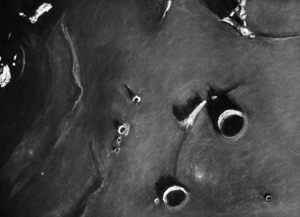
drawing by Richard Handy
In the region of the great strait separating Oceanus Procellarum and Mare Imbrium lie two small Erathosthenian age craters, 26 km Delisle and 19 km Diophantus. North is at the top right in my sketch, and a view to the west (left) shows the two major peaks of Montes Harbinger shining out, like beacons in the darkness, brightly lit by the glancing morning rays of the Sun. Their lofty summits, reaching some 2500 meters above the mare floor, dominate the night side when the terminator crosses this region. The subdued, sinuous form of wrinkle ridges close by seems a quiet counterpoint to this blazing spectacle. The Montes Harbinger are the visible remnants of the basin rim of Imbrium that existed in this area before mare lava flows inundated the terrain creating this wonderful gulf. Immediately to the southwest of Delisle is Mons Delisle, which is appears to be a partial rim of a crater, and is listed in the VMA as an feature of unknown height. Judging by my sketch, I’d guess the peak to be roughly the height of the rim of Delisle. The set of hills with a odd triangular form about 65 km to the northwest of Delisle appear associated with a junction between three crater rims, now only the highest ramparts protrude from the somber mare.
Richard Handy
Technical Details
30 November 2006. Started- 5:38 UT; end- 6:45 UT
12″ Meade SCT F10 + Binoviewer: W.O. Bino-P with 1.6X Nosepiece + W.O. WA 20mm Plossls + 2X Televue Powermate; Magnification: 244X
Lunation: 10.31 days Phase: 50.5 deg Illumination: 81.8%
Colongitude: 39.5 deg Lib in Lat.: -2 deg 04 min Lib in Long.: +00 deg 02 min.
Sketch medium: White and black Conte’ Crayons on black textured
Strathmore paper. Sketch size: 18″ x 24″.
Related Links:
Rükl plates: 9 & 19
Yesterday's LPOD: Draped Mountains
Tomorrow's LPOD: Ring Around a Basin
COMMENTS?
Register, Log in, and join in the comments.


