Difference between revisions of "December 21, 2007"

From LPOD
Jump to: navigation, search
(Created page with "__NOTOC__ =East of the Pole= <div class="post" id="post-1616"> <div class="storycontent"> <p>scott.jpg<br /> <em>image by [mailto:jeromegrenier@fre...")
 
Line 1: Line 1:
 
__NOTOC__
 
__NOTOC__
 
=East of the Pole=
 
=East of the Pole=
 +
<div class="post" id="post-1616">
  
+
<div class="storycontent">
<div class="post" id="post-1616">
+
<p>[[File:Scott.jpg|scott.jpg]]<br />
 
<div class="storycontent">
 
<p>[[File:Scott.jpg|scott.jpg]]<br />
 
 
<em>image by [mailto:jeromegrenier@free.fr Jérôme Grenier], Paris, France</em></p>
 
<em>image by [mailto:jeromegrenier@free.fr Jérôme Grenier], Paris, France</em></p>
 
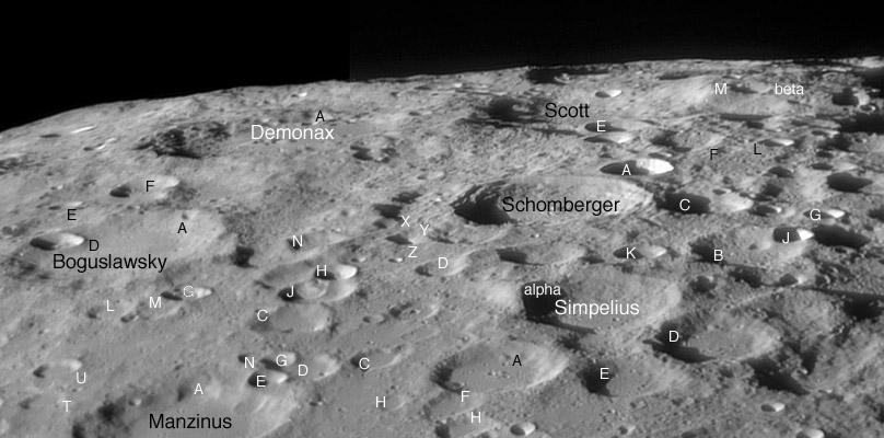
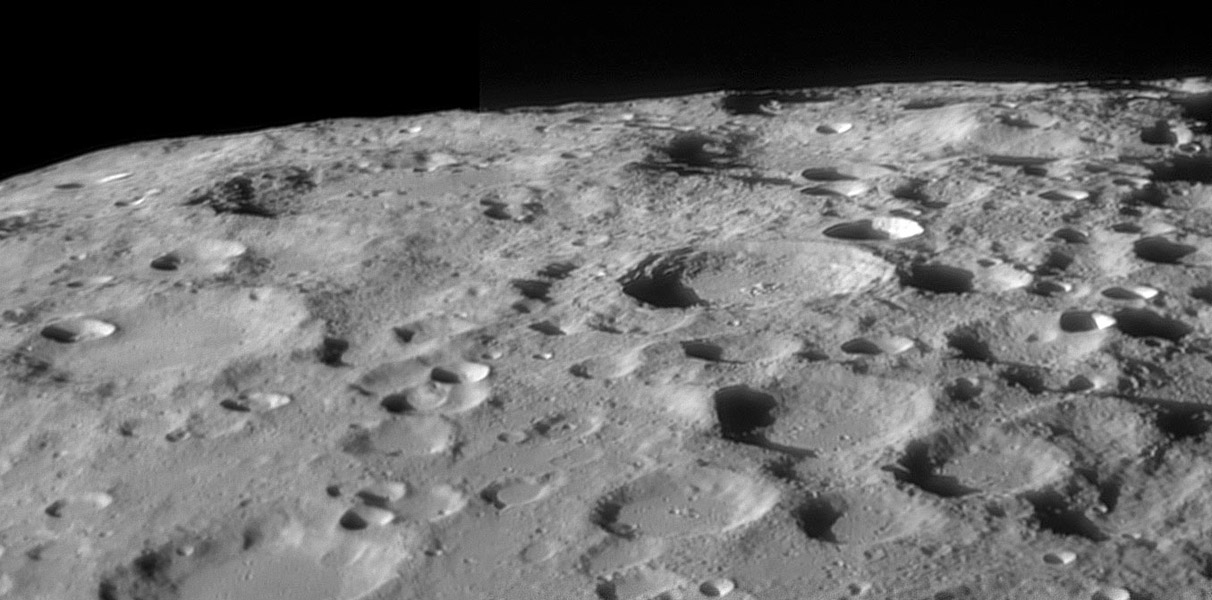
<p>What is that crater behind Moretus? Wait, that&#8217;s not Moretus! Its the smaller look-alike Schomberger. This image captures the often overlooked area just east of Moretus, on the eastern side of the lunar prime meridian. As with most places near the southern limb, navigational beacons are necessary, and Boguslawsky with its bright rim crater &#8220;D&#8221; provides it to the east, and the large plateau-like mountain Leibnitz Beta is prominent further north. Once again, Ewen Whitaker&#8217;s 50+ year old map is the best guide to this area, and I have transfered most of the designations from there and Rükl&#8217;s <em>Atlas</em> to a smaller version of Jérôme&#8217;s image below.  I was certain that the massive eastern rim of Simpelius would have received a designation long ago, and it did - it is Simpelius Alpha on the Beer and Mädler map of the 1830s. Comparing this complex, cluttered and latitudinally compressed area on Jérôme&#8217;s modern image with Beer and Mädler&#8217;s map brings a sense of reverence and awe. Mädler - he was the mapper, Beer provided the telescope - used a 3.75&#8243; refractor and had to plot everything by hand while standing at the eyepiece, yet almost every mark on his map matches a real feature. </p>
 
<p>What is that crater behind Moretus? Wait, that&#8217;s not Moretus! Its the smaller look-alike Schomberger. This image captures the often overlooked area just east of Moretus, on the eastern side of the lunar prime meridian. As with most places near the southern limb, navigational beacons are necessary, and Boguslawsky with its bright rim crater &#8220;D&#8221; provides it to the east, and the large plateau-like mountain Leibnitz Beta is prominent further north. Once again, Ewen Whitaker&#8217;s 50+ year old map is the best guide to this area, and I have transfered most of the designations from there and Rükl&#8217;s <em>Atlas</em> to a smaller version of Jérôme&#8217;s image below.  I was certain that the massive eastern rim of Simpelius would have received a designation long ago, and it did - it is Simpelius Alpha on the Beer and Mädler map of the 1830s. Comparing this complex, cluttered and latitudinally compressed area on Jérôme&#8217;s modern image with Beer and Mädler&#8217;s map brings a sense of reverence and awe. Mädler - he was the mapper, Beer provided the telescope - used a 3.75&#8243; refractor and had to plot everything by hand while standing at the eyepiece, yet almost every mark on his map matches a real feature. </p>
Line 17: Line 15:
 
[http://www.astrosurf.com/grenier/ Jérôme&#8217;s website]. </p>
 
[http://www.astrosurf.com/grenier/ Jérôme&#8217;s website]. </p>
 
<p align="center"><em>Get ready for Christmas giving and support LPOD when you buy ANYTHING from Amazon thru [http://www.lpod.org/?page_id=591 LPOD!]</em></p>
 
<p align="center"><em>Get ready for Christmas giving and support LPOD when you buy ANYTHING from Amazon thru [http://www.lpod.org/?page_id=591 LPOD!]</em></p>
</div>
+
</div>


----
 
----
 
===COMMENTS?===  
 
===COMMENTS?===  
 
Click on this icon [[image:PostIcon.jpg]] at the upper right to post a comment.
 
Click on this icon [[image:PostIcon.jpg]] at the upper right to post a comment.

Revision as of 19:01, 4 January 2015

East of the Pole

scott.jpg
image by Jérôme Grenier, Paris, France

What is that crater behind Moretus? Wait, that’s not Moretus! Its the smaller look-alike Schomberger. This image captures the often overlooked area just east of Moretus, on the eastern side of the lunar prime meridian. As with most places near the southern limb, navigational beacons are necessary, and Boguslawsky with its bright rim crater “D” provides it to the east, and the large plateau-like mountain Leibnitz Beta is prominent further north. Once again, Ewen Whitaker’s 50+ year old map is the best guide to this area, and I have transfered most of the designations from there and Rükl’s Atlas to a smaller version of Jérôme’s image below. I was certain that the massive eastern rim of Simpelius would have received a designation long ago, and it did - it is Simpelius Alpha on the Beer and Mädler map of the 1830s. Comparing this complex, cluttered and latitudinally compressed area on Jérôme’s modern image with Beer and Mädler’s map brings a sense of reverence and awe. Mädler - he was the mapper, Beer provided the telescope - used a 3.75″ refractor and had to plot everything by hand while standing at the eyepiece, yet almost every mark on his map matches a real feature.

Chuck Wood

scott-sm.jpg

Technical Details:
18 December 2007. Dmk31 AF03,Orion Optics (UK) OMC 12″ + barlow 2x + red filter.

Related Links:
Rükl plates 73 & 74
Jérôme’s website.

Get ready for Christmas giving and support LPOD when you buy ANYTHING from Amazon thru LPOD!


COMMENTS?

Click on this icon File:PostIcon.jpg at the upper right to post a comment.