Difference between revisions of "December 17, 2008"
| Line 10: | Line 10: | ||
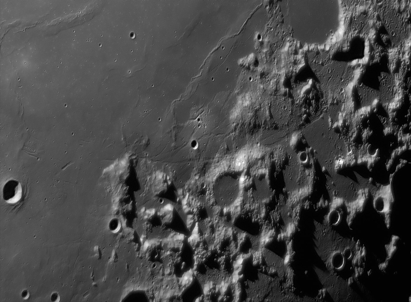
is Dawes, an 18 km diameter crater that appears to be on an island of older, rille-cut mare. To the right, pass collapse troughs, is | is Dawes, an 18 km diameter crater that appears to be on an island of older, rille-cut mare. To the right, pass collapse troughs, is | ||
the angular fortress guarded by Mt. Argaeus, that contains the Apollo 17 landing site. I was surprised to see the rilles crossing the | the angular fortress guarded by Mt. Argaeus, that contains the Apollo 17 landing site. I was surprised to see the rilles crossing the | ||
| − | floor of this inter-montane area, and amazed to recognize the [https://the-moon.us/wiki/Scarp Scarp] joining North and South [https://the-moon.us/wiki/ | + | floor of this inter-montane area, and amazed to recognize the [https://the-moon.us/wiki/Scarp Scarp] joining North and South [https://the-moon.us/wiki/North_Massif massifs!] To the north are the Littrow |
Rilles themselves, which clearly cross lava flows older than than the Serenitatis lavas to the west. Finally, at the top of the image | Rilles themselves, which clearly cross lava flows older than than the Serenitatis lavas to the west. Finally, at the top of the image | ||
within the breeched crater Le Monnier is a segment of a rille imaged by Apollo [http://www.hq.nasa.gov/office/pao/History/SP-362/ch7.1.htm astronauts] (Fig 224) and only 300-400 m wide. | within the breeched crater Le Monnier is a segment of a rille imaged by Apollo [http://www.hq.nasa.gov/office/pao/History/SP-362/ch7.1.htm astronauts] (Fig 224) and only 300-400 m wide. | ||
Latest revision as of 18:44, 13 October 2018
The Oklahoma Orbiter

image by Wes Higgins, Oklahoma, USA
This is one of the best images of the Moon i've ever seen. The resolution is excellent and the tone is good, but more important is
that the area is interesting. This is the area of the Littrow Rilles along the southeast corner of Mare Serenitatis. At the lower left
is Dawes, an 18 km diameter crater that appears to be on an island of older, rille-cut mare. To the right, pass collapse troughs, is
the angular fortress guarded by Mt. Argaeus, that contains the Apollo 17 landing site. I was surprised to see the rilles crossing the
floor of this inter-montane area, and amazed to recognize the Scarp joining North and South massifs! To the north are the Littrow
Rilles themselves, which clearly cross lava flows older than than the Serenitatis lavas to the west. Finally, at the top of the image
within the breeched crater Le Monnier is a segment of a rille imaged by Apollo astronauts (Fig 224) and only 300-400 m wide.
The Lunokhod 2 roamed the lunar surface in 1973 near this rille; I'm almost surprised that Wes' superb image does not catch any glint off it.
Chuck Wood
Technical Details
September 01, 2007 at ~10:48 UT. 18" reflector (presumably in low lunar orbit), 680nm IR pass filter, Infinity 2-1m camera, Avistack 2404 points, stack of 119 frames
Related Links
Rükl plates 24 and 25
Yesterday's LPOD: Mapping Names
Tomorrow's LPOD: M-Cubed
COMMENTS?
Register, Log in, and join in the comments.


