Difference between revisions of "December 16, 2008"
| Line 1: | Line 1: | ||
__NOTOC__ | __NOTOC__ | ||
=Mapping Names= | =Mapping Names= | ||
| + | <!-- Start of content --> | ||
<!-- ws:start:WikiTextHeadingRule:1:<h1> --> | <!-- ws:start:WikiTextHeadingRule:1:<h1> --> | ||
<!-- ws:start:WikiTextLocalImageRule:7:<img src="/file/view/LPOD-Dec16-08.jpg/51034033/LPOD-Dec16-08.jpg" alt="" title="" /> -->[[File:LPOD-Dec16-08.jpg|LPOD-Dec16-08.jpg]]<!-- ws:end:WikiTextLocalImageRule:7 --><br /> | <!-- ws:start:WikiTextLocalImageRule:7:<img src="/file/view/LPOD-Dec16-08.jpg/51034033/LPOD-Dec16-08.jpg" alt="" title="" /> -->[[File:LPOD-Dec16-08.jpg|LPOD-Dec16-08.jpg]]<!-- ws:end:WikiTextLocalImageRule:7 --><br /> | ||
| Line 19: | Line 20: | ||
<p><b>Tomorrow's LPOD:</b> [[December 17, 2008|The Oklahoma Orbiter]] </p> | <p><b>Tomorrow's LPOD:</b> [[December 17, 2008|The Oklahoma Orbiter]] </p> | ||
<hr /> | <hr /> | ||
| + | {{wiki/ArticleFooter}} | ||
Revision as of 21:28, 7 February 2015
Mapping Names

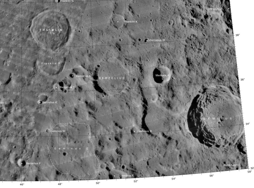
SE corner of LAC 27 from USGS Digital Atlas of the Moon. The fact that the non-crater Geminus E still exists as a name shows that lunar nomenclature needs a modern updating!
Lunar maps have been the only way to link nomenclature to specific lunar features. Grimaldi's 1651 map carried Riccioli's names - the basis for the nomenclature we use today. Beer and Mädler's map greatly increased the amount of surface detail and also featured a great expansion of nomenclature. The IAU's 1935 revised nomenclature was carried on Blagg and Müller's charts (which Fauth tried to replace with his better drawn maps), and Wilkins drew ever larger maps for his numbing detail and many new names. Most of the nearside and its nomenclature are included in the Lunar Astronautical Charts charts which follow the System of Lunar Craters. The lunar Orbiter maps were used for nearside nomenclature in 1971, and the Clementine Atlas was the first map to include nomenclature for both nearside and farside. The most readily available source of nomenclature for the nearside has been Rükl's fabled Atlas. Jenny Blue, at the US Geological Survey in Flagstaff, AZ, created one digital atlas of the Moon and has so far released 32 sheets of a second one based on Lunar Orbiter (LO) images. These ancient images have been made into a mosaic that covers the entire Moon, and here is subdivided into the same 144 quadrangles as the old USGS maps and the Clementine Atlas. The LO image mosaic in many places works well but in other regions, and especially on the farside, the image quality is poor. It is rather amazing that we are still using 40 year old images! Perhaps, someday, the much better resolution and uniformity of coverage images from SMART-1 (did that mission really exist?), Kaguya, Chandrayaan-1, Chang'e-1 and LRO will be available to make the first atlas using 21st century data. In the meantime we should thank Jenny for her herculean efforts - she is the Mary Blagg of this century - and her maps are much better!
Chuck Wood
Thanks to Jim Mosher for letting me know of this new map series!
Technical Note
This new LO atlas is not aimed at observers, who see the Moon with foreshortening every where except the sub-Earth point, but at desk explorers who need a consistent vertical view of the surface no matter where it is. This will be an invaluable reference and I plan to print all 144 sheets out (when Jenny finishes them) and bind them into a unique atlas. UPDATE: I tried printing out some of the sheets. The names (and especially the letters) are too small to be seen on a typical 8.5 x 11" sheet of paper.
Related Links
Rükl plates 15 and 16
Yesterday's LPOD: Main Lunar Crater Sequence Animated
Tomorrow's LPOD: The Oklahoma Orbiter
COMMENTS?
Register, Log in, and join in the comments.


