Difference between revisions of "August 8, 2012"
| (5 intermediate revisions by the same user not shown) | |||
| Line 1: | Line 1: | ||
__NOTOC__ | __NOTOC__ | ||
=What You Can Do From Earth= | =What You Can Do From Earth= | ||
| + | <!-- Start of content --> | ||
<!-- ws:start:WikiTextHeadingRule:0:<h1> --> | <!-- ws:start:WikiTextHeadingRule:0:<h1> --> | ||
<!-- ws:start:WikiTextLocalImageRule:6:<img src="/file/view/LPOD-Aug8-12.jpg/356775168/LPOD-Aug8-12.jpg" alt="" title="" /> -->[[File:LPOD-Aug8-12.jpg|LPOD-Aug8-12.jpg]]<!-- ws:end:WikiTextLocalImageRule:6 --><br /> | <!-- ws:start:WikiTextLocalImageRule:6:<img src="/file/view/LPOD-Aug8-12.jpg/356775168/LPOD-Aug8-12.jpg" alt="" title="" /> -->[[File:LPOD-Aug8-12.jpg|LPOD-Aug8-12.jpg]]<!-- ws:end:WikiTextLocalImageRule:6 --><br /> | ||
<em>image by [mailto:jocelyn.serot@free.fr Jocelyn Serot], France</em><br /> | <em>image by [mailto:jocelyn.serot@free.fr Jocelyn Serot], France</em><br /> | ||
<br /> | <br /> | ||
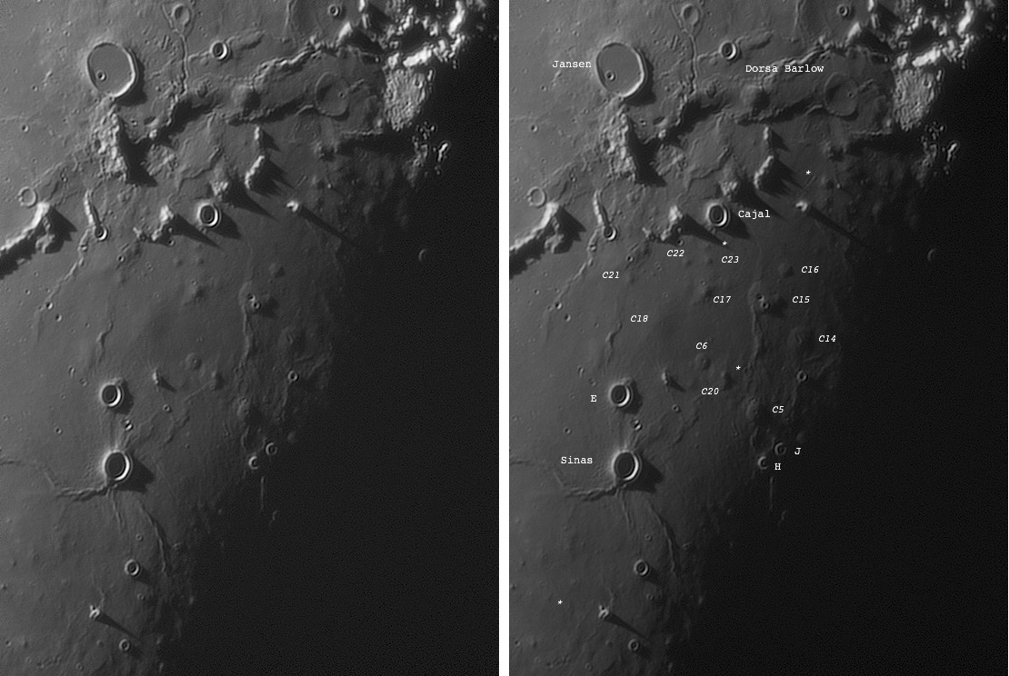
| − | Here's an image taken this morning. My eye was first caught by the spike-shaped shadows cast by the moutains SE of Jansen (N is up). Then | + | Here's an image taken this morning. My eye was first caught by the spike-shaped shadows cast by the moutains SE of Jansen (N is up). Then I realized that the region was full of domes. Not having an atlas at hand, I decided to image it. After processing, I realized that this region has been described several times in LPOD - in particular here on [http://www2.lpod.org/wiki/February_24,_2008 Feb 24, 2008]. The lighting in my case is a bit more favorable, showing the various domes NE of Sinas quite neatly. I attach an annotated image in which I've re-used the labels you used in the previous LPOD. There are some new ones (?), which I've marked with a star. The most noticeable is just N of C23. I also have the impression that the whole region SW of Sinas is also a dome field. Is it? Apart from this, the view of Dorsa Barlow is interesting. What is the circular formation at its E extremity? Could it be a buried crater? It seems tilted and faulted.<br /> |
<br /> | <br /> | ||
<em>[mailto:jocelyn.serot@free.fr Jocelyn Serot]</em><br /> | <em>[mailto:jocelyn.serot@free.fr Jocelyn Serot]</em><br /> | ||
| Line 13: | Line 14: | ||
<br /> | <br /> | ||
<strong>Related Links</strong><br /> | <strong>Related Links</strong><br /> | ||
| − | Rükl plate [ | + | Rükl plate [https://the-moon.us/wiki/R%C3%BCkl_36 36]<br /> |
<br /> | <br /> | ||
| + | <p><b>Yesterday's LPOD:</b> [[August 7, 2012|Intersections]] </p> | ||
| + | <p><b>Tomorrow's LPOD:</b> [[August 9, 2012|More Flows]] </p> | ||
<hr /> | <hr /> | ||
| − | + | {{wiki/ArticleFooter}} | |
| − | |||
| − | |||
| − | |||
| − | |||
| − | |||
| − | |||
| − | |||
| − | |||
| − | |||
| − | |||
| − | |||
Latest revision as of 08:24, 28 October 2018
What You Can Do From Earth

image by Jocelyn Serot, France
Here's an image taken this morning. My eye was first caught by the spike-shaped shadows cast by the moutains SE of Jansen (N is up). Then I realized that the region was full of domes. Not having an atlas at hand, I decided to image it. After processing, I realized that this region has been described several times in LPOD - in particular here on Feb 24, 2008. The lighting in my case is a bit more favorable, showing the various domes NE of Sinas quite neatly. I attach an annotated image in which I've re-used the labels you used in the previous LPOD. There are some new ones (?), which I've marked with a star. The most noticeable is just N of C23. I also have the impression that the whole region SW of Sinas is also a dome field. Is it? Apart from this, the view of Dorsa Barlow is interesting. What is the circular formation at its E extremity? Could it be a buried crater? It seems tilted and faulted.
Jocelyn Serot
Technical Details
Aug. 7, 2012, 03-12-14. 12" Dall-Kirkham reflector. Prime focus (F/17). IR>742 filter. Basler ACa640-100gm camera. Processing: Autostakkert2+Registax 6.
Related Links
Rükl plate 36
Yesterday's LPOD: Intersections
Tomorrow's LPOD: More Flows
COMMENTS?
Register, Log in, and join in the comments.


