Difference between revisions of "August 7, 2006"

From LPOD
Jump to: navigation, search
(Created page with "__NOTOC__ =Pitted Softness= <div class="post" id="post-480"> <div class="storycontent"> <p>LacusTimorisLPOD.jpg<br /> <em>image by [mail...")
 
Line 1: Line 1:
 
__NOTOC__
 
__NOTOC__
 
=Pitted Softness=
 
=Pitted Softness=
 +
<div class="post" id="post-480">
  
+
<div class="storycontent">
<div class="post" id="post-480">
+
<p>[[File:LacusTimorisLPOD.jpg|LacusTimorisLPOD.jpg]]<br />
 
<div class="storycontent">
 
<p>[[File:LacusTimorisLPOD.jpg|LacusTimorisLPOD.jpg]]<br />
 
 
<em>image by [mailto:bob_p@earthlink.net Bob Pilz]</em></p>
 
<em>image by [mailto:bob_p@earthlink.net Bob Pilz]</em></p>
 
<p>This remarkablke view, with a mere 6&#8243; reflector, crisply shows a region that on Earth would be called swampy. Little of its older highland rocks are visible and its low patches were once wet with small lakes and puddles of lava. But the most intriguing landscape features are the rounded crater rims (see [http://www.sydneyobservatory.com.au/blog/?p=76 Wurzelbauer] and Gauricus) and the pittiness and hilliness (p&#038;h). These two characteristics are probably related. Although the 30 year old US Geological Survey [http://www.lpi.usra.edu/resources/mapcatalog/usgs/I824/72dpi.jpg geologic map] interprets the p&#038;h terrain as of volcanic origin, a more modern view would be that it is probably debris from an impact basin. Most likely, the p&#038;h terrain is ejecta from the formation of the Humorum impact basin. Most other areas around the basin that were covered by its ejecta are now flooded by mare lava or carpeted by the younger Orientale debris. The roundness of the rim of Gauricus is emphasized by its sharply-bounded - and younger - flat floor, but it is similar to other old craters to the south and west of it. Most of the craters in this area are younger than the Humorum debris, and many of the 20-30 km wide slightly irregular, somewhat shallow craters are probably secondaries from the Orientale impact.</p>
 
<p>This remarkablke view, with a mere 6&#8243; reflector, crisply shows a region that on Earth would be called swampy. Little of its older highland rocks are visible and its low patches were once wet with small lakes and puddles of lava. But the most intriguing landscape features are the rounded crater rims (see [http://www.sydneyobservatory.com.au/blog/?p=76 Wurzelbauer] and Gauricus) and the pittiness and hilliness (p&#038;h). These two characteristics are probably related. Although the 30 year old US Geological Survey [http://www.lpi.usra.edu/resources/mapcatalog/usgs/I824/72dpi.jpg geologic map] interprets the p&#038;h terrain as of volcanic origin, a more modern view would be that it is probably debris from an impact basin. Most likely, the p&#038;h terrain is ejecta from the formation of the Humorum impact basin. Most other areas around the basin that were covered by its ejecta are now flooded by mare lava or carpeted by the younger Orientale debris. The roundness of the rim of Gauricus is emphasized by its sharply-bounded - and younger - flat floor, but it is similar to other old craters to the south and west of it. Most of the craters in this area are younger than the Humorum debris, and many of the 20-30 km wide slightly irregular, somewhat shallow craters are probably secondaries from the Orientale impact.</p>
Line 17: Line 15:
 
[http://www.skyinsight.com/lunaratlas/images/v/Section20/9-26-05+pan-3.jpg.html?g2_imageViewsIndex=1&#038;g2_GALLERYSID=b6fa951e8ad8eed502038160866b3b33 Another 6&#8243; view]<br />
 
[http://www.skyinsight.com/lunaratlas/images/v/Section20/9-26-05+pan-3.jpg.html?g2_imageViewsIndex=1&#038;g2_GALLERYSID=b6fa951e8ad8eed502038160866b3b33 Another 6&#8243; view]<br />
 
[http://www.lpi.usra.edu/resources/lunar_orbiter/images/img/iv_131_h2.jpg Lunar Orbiter IV view]</p>
 
[http://www.lpi.usra.edu/resources/lunar_orbiter/images/img/iv_131_h2.jpg Lunar Orbiter IV view]</p>
</div>
+
</div>


----
 
----
 
===COMMENTS?===  
 
===COMMENTS?===  
 
Click on this icon [[image:PostIcon.jpg]] at the upper right to post a comment.
 
Click on this icon [[image:PostIcon.jpg]] at the upper right to post a comment.

Revision as of 18:41, 4 January 2015

Pitted Softness

LacusTimorisLPOD.jpg
image by Bob Pilz

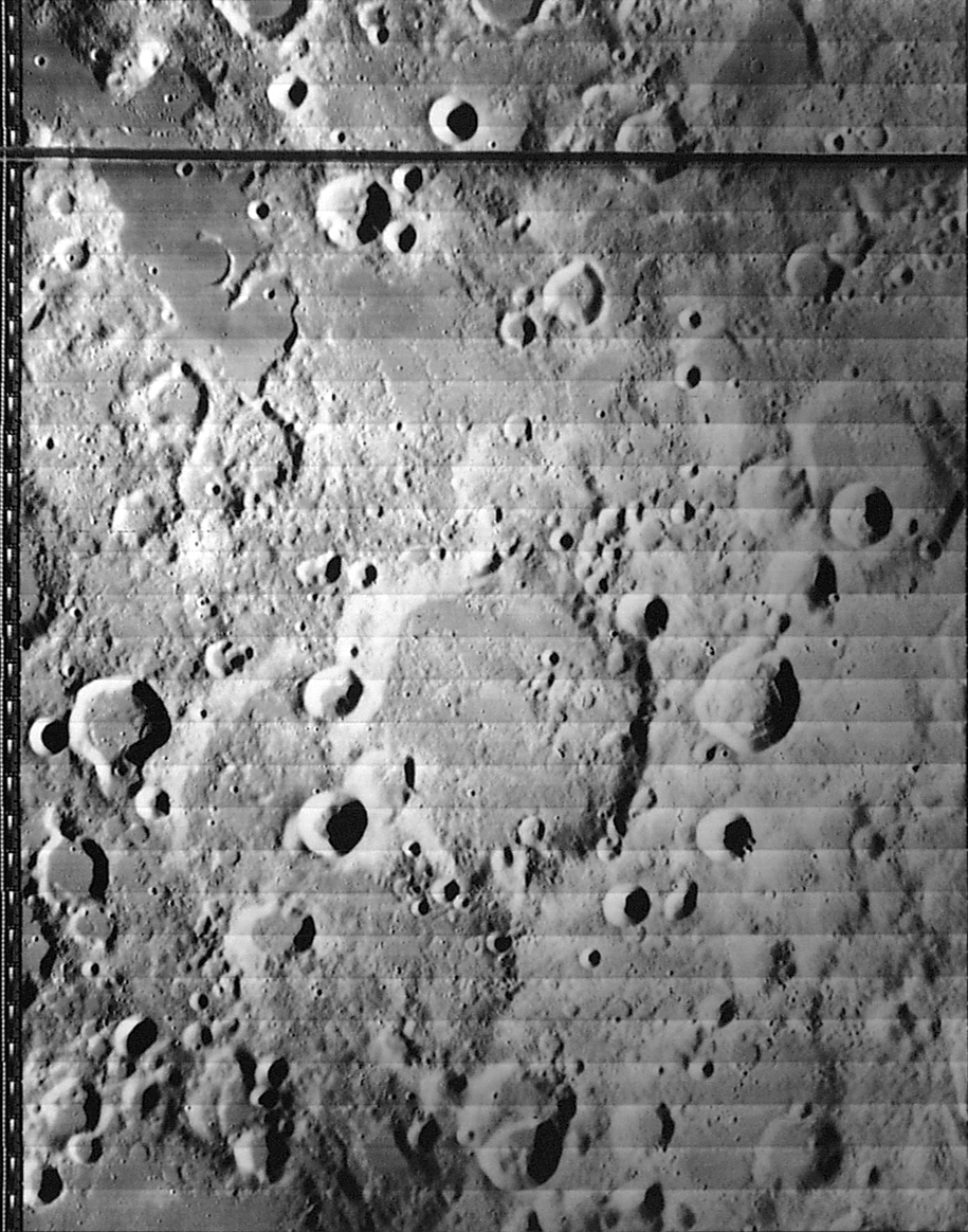
This remarkablke view, with a mere 6″ reflector, crisply shows a region that on Earth would be called swampy. Little of its older highland rocks are visible and its low patches were once wet with small lakes and puddles of lava. But the most intriguing landscape features are the rounded crater rims (see Wurzelbauer and Gauricus) and the pittiness and hilliness (p&h). These two characteristics are probably related. Although the 30 year old US Geological Survey geologic map interprets the p&h terrain as of volcanic origin, a more modern view would be that it is probably debris from an impact basin. Most likely, the p&h terrain is ejecta from the formation of the Humorum impact basin. Most other areas around the basin that were covered by its ejecta are now flooded by mare lava or carpeted by the younger Orientale debris. The roundness of the rim of Gauricus is emphasized by its sharply-bounded - and younger - flat floor, but it is similar to other old craters to the south and west of it. Most of the craters in this area are younger than the Humorum debris, and many of the 20-30 km wide slightly irregular, somewhat shallow craters are probably secondaries from the Orientale impact.

Chuck Wood

Technical Details:
18 July 2006, 09:03 UT. 150mm f/5 Newtonian reflector + Televue 3x Barlow + DMK 21BF04 B/W camera + ‘Blue’ IR-block filter; 15fps, 1/27 sec, 600/6000 frames; processed in Registax, ImagesPlus, PhotoShop CS.

Related Links:
Rükl chart 63
Bob’s lunar gallery
Another 6″ view
Lunar Orbiter IV view


COMMENTS?

Click on this icon File:PostIcon.jpg at the upper right to post a comment.