Difference between revisions of "August 4, 2011"
| Line 1: | Line 1: | ||
__NOTOC__ | __NOTOC__ | ||
=Putrid Ridge Spoils Spurr= | =Putrid Ridge Spoils Spurr= | ||
| − | |||
<!-- ws:start:WikiTextHeadingRule:0:<h1> --> | <!-- ws:start:WikiTextHeadingRule:0:<h1> --> | ||
<!-- ws:start:WikiTextLocalImageRule:6:<img src="/file/view/LPOD-Aug4-11.jpg/244212517/LPOD-Aug4-11.jpg" alt="" title="" /> -->[[File:LPOD-Aug4-11.jpg|LPOD-Aug4-11.jpg]]<!-- ws:end:WikiTextLocalImageRule:6 --><br /> | <!-- ws:start:WikiTextLocalImageRule:6:<img src="/file/view/LPOD-Aug4-11.jpg/244212517/LPOD-Aug4-11.jpg" alt="" title="" /> -->[[File:LPOD-Aug4-11.jpg|LPOD-Aug4-11.jpg]]<!-- ws:end:WikiTextLocalImageRule:6 --><br /> | ||
| − | <em>south up image by [mailto:gtarsoudis@gmail.com George Tarsoudis], Greece</em><br /> | + | <em>south up image by [mailto:gtarsoudis@gmail.com" rel="nofollow George Tarsoudis], Greece</em><br /> |
<br /> | <br /> | ||
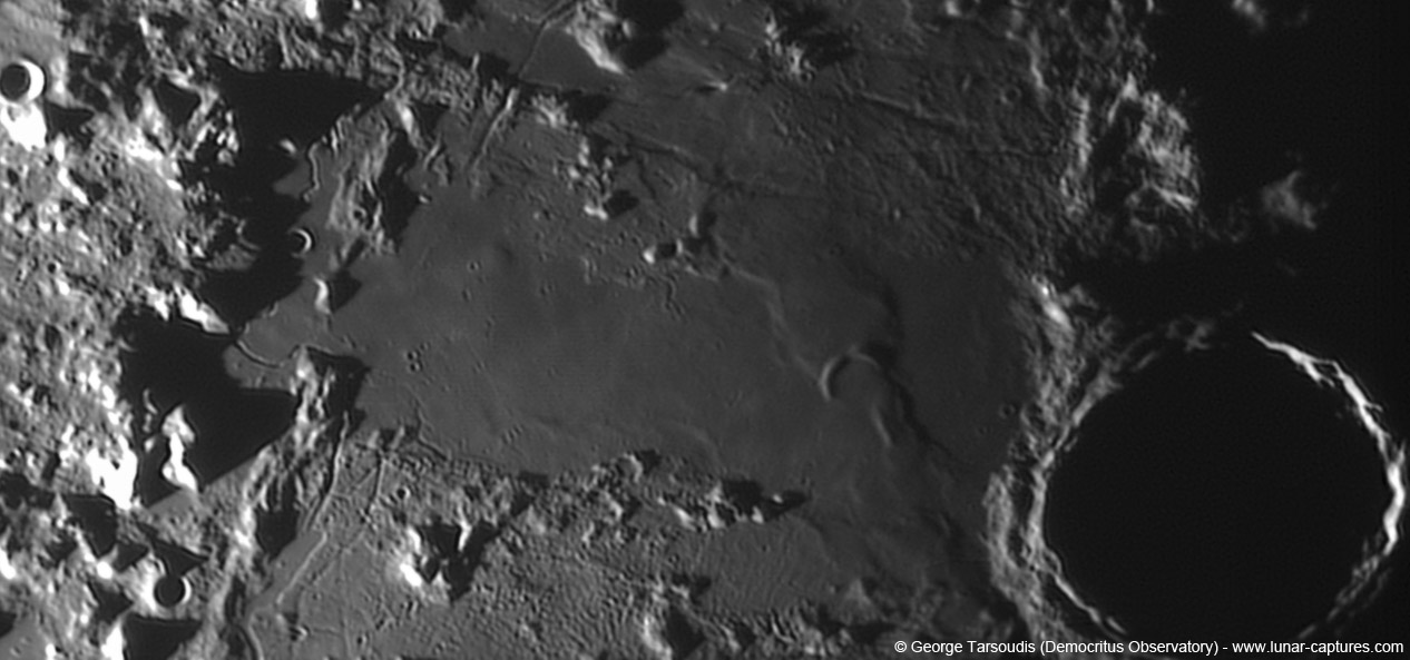
Here is an interesting stratigraphic problem to puzzle over. Palus Putredinus, the broad band of mare stretching <br /> | Here is an interesting stratigraphic problem to puzzle over. Palus Putredinus, the broad band of mare stretching <br /> | ||
| Line 15: | Line 14: | ||
than Spurr? Was it responsible for the loss of Spurr's western rim? Why did the ridge form?<br /> | than Spurr? Was it responsible for the loss of Spurr's western rim? Why did the ridge form?<br /> | ||
<br /> | <br /> | ||
| − | <em>[mailto:tychocrater@yahoo.com Chuck Wood]</em><br /> | + | <em>[mailto:tychocrater@yahoo.com" rel="nofollow Chuck Wood]</em><br /> |
<br /> | <br /> | ||
<strong>Technical Details</strong><br /> | <strong>Technical Details</strong><br /> | ||
| Line 22: | Line 21: | ||
<strong>Related Links</strong><br /> | <strong>Related Links</strong><br /> | ||
Rükl plate [http://the-moon.wikispaces.com/R%C3%BCkl+22 22]<br /> | Rükl plate [http://the-moon.wikispaces.com/R%C3%BCkl+22 22]<br /> | ||
| − | George's [http://www.lunar-captures.com/ website]<br /> | + | George's [http://www.lunar-captures.com/" rel="nofollow website]<br /> |
<br /> | <br /> | ||
<hr /> | <hr /> | ||
Revision as of 22:20, 4 January 2015
Putrid Ridge Spoils Spurr

south up image by " rel="nofollow George Tarsoudis, Greece
Here is an interesting stratigraphic problem to puzzle over. Palus Putredinus, the broad band of mare stretching
from the Apennines to Archimedes, interupts the band of older and rougher terrain to its north and south. The
truncation of the rilles paralleling the Apennines shows that the Putrid lavas are younger; they were probably
partially fed by Hadley Rille on the left against the mountains. I imagine that lavas fill an area that had faulted
downward as a giant graben. Near Archimedes is the small (D = 13 km) half crater known as Spurr. The crater
formed on an earier and lower surface, and its north rim was somehow destroyed by the last stages of Putrid
lavas. But what was the role of the broad mare ridge passing under or around Spurr? Is the ridge older or younger
than Spurr? Was it responsible for the loss of Spurr's western rim? Why did the ridge form?
" rel="nofollow Chuck Wood
Technical Details
July 8, 2011, 1811 UT. 10 inch @f/6.3, camera Unibrain fire-i 785, filter Red, barlow 3X.
Related Links
Rükl plate 22
George's " rel="nofollow website


