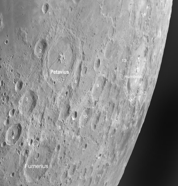
mosaic image by Павел Пресняков (Pavel Presnyakov), Kiev, Ukraine. In a possible OPAM the main craters could be named and others numbered with desciptions on the facing page.
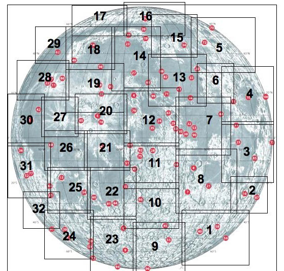
Is it possible to create a great Observer’s Photographic Atlas of the Moon (OPAM)? I have most of Moon maps and atlases that have been published over the last 100 years, and none is exactly the companion I want at the telescope. Let me mention three good ones, that each miss for my needs. The S&T Field Map of the Moon is handy, large enough to identify many features, and shows a whole quadrant of the Moon. It is not photographic so it is sometimes difficult to recognize bright little landmark craters that help navigate, and the names are difficult to read near the limb where the background color changes from light gray to light brown. Rükl’s classic Atlas of the Moon is nearly perfect for desk use, but at the telescope it is heavy, impossible to fold open to a page of interest, and is divided into 72 plates, each showing an inconveniently small area for telescope navigation. And of course, it is not photographic. The old Hatfield Photographic Lunar Atlas has many excellent attributes: it is not bulky, but is big enough to show a decent size area of the Moon, it has 5-6 views of each field, and it has sketch maps that identify all the named and lettered craters. Its downsides are that the photos are low resolution, 5-6 photos are too many while observing, and the map is very hard to read. During the last 3-5 years I have experimented with many ideas for a really useful OPAM - here is a summary: It should be spiral bound, have a limited number (30?) of sheets (a compromise of a relatively large area and large image scale), use high quality photos, and unambiguously display names of all major features. The image above shows a possible layout of a 32 sheet atlas and an image of map #2. I find a number of problems with this possible atlas design, but you can tell me what you like and don’t, and what you’d like for your perfect OPAM.
Technical Details:
May 21, 2007. 10″ TAL-250K Klevtsov + EVS-135, b/w 1280×1024, 15fps; 200/1000 in Registax4.
Related Links:
This is just a piece of an excellent mosaic seen here.
Yesterday's LPOD: No Stratton
Tomorrow's LPOD: Bright Stuff

Boundaries of possible OPAM, shown on S&T’s map of the Lunar 100. Note that fields are meant to show a coherent geologic region and hence are of different sizes, but they would all be reproduced at the same scale. Opposite each map would be a page describing interesting features to oserve, as in a Norton’s Sky Atlas.
COMMENTS?
Register, Log in, and join in the comments.


