Difference between revisions of "April 29, 2010"
| Line 4: | Line 4: | ||
<!-- ws:start:WikiTextHeadingRule:1:<h1> --> | <!-- ws:start:WikiTextHeadingRule:1:<h1> --> | ||
<!-- ws:start:WikiTextLocalImageRule:16:<img src="/file/view/LPOD-April-29-10.jpg/138043183/LPOD-April-29-10.jpg" alt="" title="" /> -->[[File:LPOD-April-29-10.jpg|LPOD-April-29-10.jpg]]<!-- ws:end:WikiTextLocalImageRule:16 --><br /> | <!-- ws:start:WikiTextLocalImageRule:16:<img src="/file/view/LPOD-April-29-10.jpg/138043183/LPOD-April-29-10.jpg" alt="" title="" /> -->[[File:LPOD-April-29-10.jpg|LPOD-April-29-10.jpg]]<!-- ws:end:WikiTextLocalImageRule:16 --><br /> | ||
| − | <em>image by [mailto:ph7_347@hotmail.com | + | <em>image by [mailto:ph7_347@hotmail.com </em><br /> |
<br /> | <br /> | ||
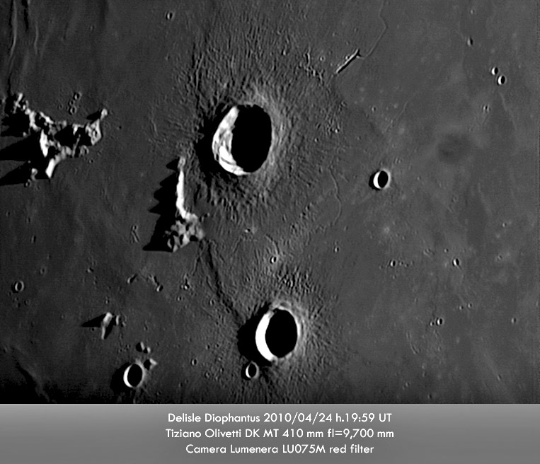
| − | This is the second best image of Diopantus, Delisle and their rilles that I know of. But coming in second to an Apollo 15 Metric [http://www.lpod.org/coppermine/displayimage.php?pid=459&fullsize=1 | + | This is the second best image of Diopantus, Delisle and their rilles that I know of. But coming in second to an Apollo 15 Metric [http://www.lpod.org/coppermine/displayimage.php?pid=459&fullsize=1 simulations] that show Copernicus and other large fresh craters to be surrounded by strong variations in small scale topographic roughness. Notice also that Delisle Mountain blocked the westward movement of crater ejecta, showing again that some ejecta follows very low - ground-hugging? - trajectories. The Delisle Rille is another example of rilles starting at elongated rimless trenches, in this case, cutting through the near-end edge like an after thought. The trench is probably a collapse over the vent area where the magma from depth breached the surface. If it is like similar vents in Hawaii it probably is on a very slight rise and may have a low spatter rampart that contained a liquid lava lake, that ultimately drained through the rille. The Diophantus Rille that runs between Delisle and Diophantus has no obvious beginning point, but the series of small rimless depressions near the west end suggests that end might be near the vent. And the LTO [http://www.lpi.usra.edu/resources/mapcatalog/LTO/lto39b2_1/ supports this by indicating that the downhill direction is to the east, toward the center of the Imbrium Basin.<br /> |
<br /> | <br /> | ||
| − | <em>[mailto:tychocrater@yahoo.com | + | <em>[mailto:tychocrater@yahoo.com </em><br /> |
<br /> | <br /> | ||
<strong>Technical Details</strong><br /> | <strong>Technical Details</strong><br /> | ||
| Line 14: | Line 14: | ||
<br /> | <br /> | ||
<strong>Related Links</strong><br /> | <strong>Related Links</strong><br /> | ||
| − | Rükl plate | + | Rükl plate <a class="wiki_link" href="http://the-moon.wikispaces.com/R%C3%BCkl+19">10]<br /> |
How [http://lpod.wikispaces.com/February+5%2C+2008 wide] is the Diophantus Rille?<br /> | How [http://lpod.wikispaces.com/February+5%2C+2008 wide] is the Diophantus Rille?<br /> | ||
<br /> | <br /> | ||
<hr /> | <hr /> | ||
| − | <div>You can support LPOD when you buy any book from Amazon thru | + | <div>You can support LPOD when you buy any book from Amazon thru <a class="wiki_link_ext" href="http://www.lpod.org/?page_id=591"LPOD!]<br /> |
</div> | </div> | ||
Revision as of 22:16, 2 January 2015
Rilles And Roughness

image by [mailto:ph7_347@hotmail.com
This is the second best image of Diopantus, Delisle and their rilles that I know of. But coming in second to an Apollo 15 Metric simulations that show Copernicus and other large fresh craters to be surrounded by strong variations in small scale topographic roughness. Notice also that Delisle Mountain blocked the westward movement of crater ejecta, showing again that some ejecta follows very low - ground-hugging? - trajectories. The Delisle Rille is another example of rilles starting at elongated rimless trenches, in this case, cutting through the near-end edge like an after thought. The trench is probably a collapse over the vent area where the magma from depth breached the surface. If it is like similar vents in Hawaii it probably is on a very slight rise and may have a low spatter rampart that contained a liquid lava lake, that ultimately drained through the rille. The Diophantus Rille that runs between Delisle and Diophantus has no obvious beginning point, but the series of small rimless depressions near the west end suggests that end might be near the vent. And the LTO [http://www.lpi.usra.edu/resources/mapcatalog/LTO/lto39b2_1/ supports this by indicating that the downhill direction is to the east, toward the center of the Imbrium Basin.
[mailto:tychocrater@yahoo.com
Technical Details
See image
Related Links
Rükl plate <a class="wiki_link" href="http://the-moon.wikispaces.com/R%C3%BCkl+19">10]
How wide is the Diophantus Rille?
COMMENTS?
Click on this icon File:PostIcon.jpg at the upper right to post a comment.


