Difference between revisions of "April 27, 2004"
| (7 intermediate revisions by the same user not shown) | |||
| Line 1: | Line 1: | ||
__NOTOC__ | __NOTOC__ | ||
=A Penetrating View of Imbrium= | =A Penetrating View of Imbrium= | ||
| + | <!-- Start of content --> | ||
<table width="640" border="0" align="center" cellpadding="6" cellspacing="2"> | <table width="640" border="0" align="center" cellpadding="6" cellspacing="2"> | ||
<tr> | <tr> | ||
| Line 8: | Line 9: | ||
<tr> | <tr> | ||
<td colspan="2"><div align="center"> | <td colspan="2"><div align="center"> | ||
| − | + | {{HoverImage|LPOD-2004-04-27.jpeg|LPOD-2004-04-27b.jpeg}}</div> | |
</td> | </td> | ||
</tr> | </tr> | ||
| Line 14: | Line 15: | ||
<table width="100%" border="0" cellpadding="8"> | <table width="100%" border="0" cellpadding="8"> | ||
<tr> | <tr> | ||
| − | <td><div align="center | + | <td><div align="center"><p>Image Credit: [mailto:campbellb@nasm.si.edu Bruce Campbell]</p></div></td> |
</tr> | </tr> | ||
</table> | </table> | ||
| Line 22: | Line 23: | ||
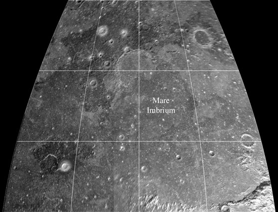
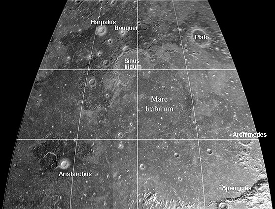
about equal to a few times the wavelength used. Optical sensors probe the top microns of the lunar surface, but this 70-cm radar image (from the giant Arecibo radio telescope in Puerto Rico) penetrates several meters into the lunar soil. Optical images provide 2-dimensional surface information but radar tells | about equal to a few times the wavelength used. Optical sensors probe the top microns of the lunar surface, but this 70-cm radar image (from the giant Arecibo radio telescope in Puerto Rico) penetrates several meters into the lunar soil. Optical images provide 2-dimensional surface information but radar tells | ||
about volume. Bruce Campbell of the Smithsonian Institution is using these radar images as probes of the depth properties of the lunar regolith (or soils). For example, the northern part of the ejecta blanket of Plato is quite distinct here, where it is less so in optical and shorter-wavelength radar images. | about volume. Bruce Campbell of the Smithsonian Institution is using these radar images as probes of the depth properties of the lunar regolith (or soils). For example, the northern part of the ejecta blanket of Plato is quite distinct here, where it is less so in optical and shorter-wavelength radar images. | ||
| − | Presumably this is due to radar scattering from subsurface blocky ejecta. The difference in brightness across Mare Imbrium probably relates to the amount of titanium in the lava flows - compare this image with a [ | + | Presumably this is due to radar scattering from subsurface blocky ejecta. The difference in brightness across Mare Imbrium probably relates to the amount of titanium in the lava flows - compare this image with a [[February_8,_2004|multi-spectral]] view. |
</p> | </p> | ||
<blockquote> | <blockquote> | ||
| Line 31: | Line 32: | ||
<p class="story"><b>Related Links:</b><br> | <p class="story"><b>Related Links:</b><br> | ||
[http://www.nasm.si.edu/research/ceps/research/moon/radar_poles_detail.cfm Lunar Radar Mapping]</p> | [http://www.nasm.si.edu/research/ceps/research/moon/radar_poles_detail.cfm Lunar Radar Mapping]</p> | ||
| − | <p | + | <p><b>Yesterday's LPOD:</b> [[April 26, 2004|America Hits the Moon!]] </p> |
| + | <p><b>Tomorrow's LPOD:</b> [[April 28, 2004|Our Furture on the Moon]] </p> | ||
</td> | </td> | ||
</tr> | </tr> | ||
| Line 39: | Line 41: | ||
<p align="center" class="main_titles"><b>Author & Editor:</b><br> | <p align="center" class="main_titles"><b>Author & Editor:</b><br> | ||
[mailto:tychocrater@yahoo.com Charles A. Wood]</p> | [mailto:tychocrater@yahoo.com Charles A. Wood]</p> | ||
| − | < | + | <!-- Cleanup of credits --> |
| − | + | <!-- Cleanup of credits --> | |
| − | < | + | <!-- Cleanup of credits --> |
| − | + | <!-- Cleanup of credits --> | |
| − | < | + | <!-- Cleanup of credits --> |
| − | + | <!-- Cleanup of credits --> | |
| + | <!-- Cleanup of credits --> | ||
<p> </p> | <p> </p> | ||
| − | ---- | + | <!-- End of content --> |
| − | + | {{wiki/ArticleFooter}} | |
| − | |||
Latest revision as of 19:16, 7 February 2015
A Penetrating View of Imbrium
Image Credit: Bruce Campbell |
|
A Penetrating View of Imbrium We observe the Moon with our green-sensitive eyeballs, red-sensitive ccd cameras, multi-spectral spacecraft sensors and also with radar of various wavelengths. Each view provides somewhat different information about the top layers of the Moon. Each detector provides information to a depth about equal to a few times the wavelength used. Optical sensors probe the top microns of the lunar surface, but this 70-cm radar image (from the giant Arecibo radio telescope in Puerto Rico) penetrates several meters into the lunar soil. Optical images provide 2-dimensional surface information but radar tells about volume. Bruce Campbell of the Smithsonian Institution is using these radar images as probes of the depth properties of the lunar regolith (or soils). For example, the northern part of the ejecta blanket of Plato is quite distinct here, where it is less so in optical and shorter-wavelength radar images. Presumably this is due to radar scattering from subsurface blocky ejecta. The difference in brightness across Mare Imbrium probably relates to the amount of titanium in the lava flows - compare this image with a multi-spectral view. Technical Details: Attached is a better view of the whole area at 70-cm wavelength; sinusoidal projection. The data were collected at Arecibo in 2000, and have a full spatial resolution of 400 m per pixel (this image is downsampled). The polarization is "opposite sense circular (LR)"; no scattering law has been removed. We use a fully focused radar processing approach to obtain high spatial resolution over relatively long integration times. Related Links: Yesterday's LPOD: America Hits the Moon! Tomorrow's LPOD: Our Furture on the Moon |
Author & Editor:
Charles A. Wood
COMMENTS?
Register, Log in, and join in the comments.


