Difference between revisions of "April 26, 2012"
| Line 1: | Line 1: | ||
__NOTOC__ | __NOTOC__ | ||
=X-Raying Imbrium= | =X-Raying Imbrium= | ||
| − | |||
<!-- ws:start:WikiTextHeadingRule:0:<h1> --> | <!-- ws:start:WikiTextHeadingRule:0:<h1> --> | ||
<!-- ws:start:WikiTextLocalImageRule:6:<img src="/file/view/LPOD-Apr26-12.jpg/325311432/LPOD-Apr26-12.jpg" alt="" title="" /> -->[[File:LPOD-Apr26-12.jpg|LPOD-Apr26-12.jpg]]<!-- ws:end:WikiTextLocalImageRule:6 --><br /> | <!-- ws:start:WikiTextLocalImageRule:6:<img src="/file/view/LPOD-Apr26-12.jpg/325311432/LPOD-Apr26-12.jpg" alt="" title="" /> -->[[File:LPOD-Apr26-12.jpg|LPOD-Apr26-12.jpg]]<!-- ws:end:WikiTextLocalImageRule:6 --><br /> | ||
| − | <em>image by [mailto:rosen@pixmix.a.se Peter Rosén], Stockholm, Sweden</em><br /> | + | <em>image by [mailto:rosen@pixmix.a.se" rel="nofollow Peter Rosén], Stockholm, Sweden</em><br /> |
<br /> | <br /> | ||
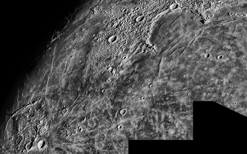
| − | Look familiar? This is Peter's version of the area shown in [http://lpod.wikispaces.com/April+26%2C+2012 yesterday's LPOD] which was based on visualizing digital topography data. Peter used [http://www.hdrsoft.com/ HDR] techniques in imaging and processing to increase contrast and enhance faint details in the mare and to show some of the same features visible yesterday. But first, notice the enhancement of splotches and streaks of rays, giving an x-ray feel to the view. Such albedo features did not show up on the wonderful topo image, showing that it takes multiple approaches to see everything. The narrow, curved mare ridge deep inside Sinus Iridum is part of the possible crater or inner basin ring suggested by the topo image. Also visible are the oppositely curved ridges that mark Imbrium's inner basin ring, and perhaps the submerged continuation of the Jura Mountains. Finally, the remarkably straight ridge stretching from the Aristarchus Plateau to Rümker is well seen, but there is no evidence of the 150-300 m lowering of the ground east of the ridge. Once again, different types of data tell different stories, each documenting just a piece of the totality that is the Moon.<br /> | + | Look familiar? This is Peter's version of the area shown in [http://lpod.wikispaces.com/April+26%2C+2012 yesterday's LPOD] which was based on visualizing digital topography data. Peter used [http://www.hdrsoft.com/" rel="nofollow HDR] techniques in imaging and processing to increase contrast and enhance faint details in the mare and to show some of the same features visible yesterday. But first, notice the enhancement of splotches and streaks of rays, giving an x-ray feel to the view. Such albedo features did not show up on the wonderful topo image, showing that it takes multiple approaches to see everything. The narrow, curved mare ridge deep inside Sinus Iridum is part of the possible crater or inner basin ring suggested by the topo image. Also visible are the oppositely curved ridges that mark Imbrium's inner basin ring, and perhaps the submerged continuation of the Jura Mountains. Finally, the remarkably straight ridge stretching from the Aristarchus Plateau to Rümker is well seen, but there is no evidence of the 150-300 m lowering of the ground east of the ridge. Once again, different types of data tell different stories, each documenting just a piece of the totality that is the Moon.<br /> |
<br /> | <br /> | ||
| − | <em>[mailto:tychocrater@yahoo.com Chuck Wood]</em><br /> | + | <em>[mailto:tychocrater@yahoo.com" rel="nofollow Chuck Wood]</em><br /> |
<br /> | <br /> | ||
<strong>Technical Details</strong><br /> | <strong>Technical Details</strong><br /> | ||
Revision as of 22:30, 4 January 2015
X-Raying Imbrium

image by " rel="nofollow Peter Rosén, Stockholm, Sweden
Look familiar? This is Peter's version of the area shown in yesterday's LPOD which was based on visualizing digital topography data. Peter used " rel="nofollow HDR techniques in imaging and processing to increase contrast and enhance faint details in the mare and to show some of the same features visible yesterday. But first, notice the enhancement of splotches and streaks of rays, giving an x-ray feel to the view. Such albedo features did not show up on the wonderful topo image, showing that it takes multiple approaches to see everything. The narrow, curved mare ridge deep inside Sinus Iridum is part of the possible crater or inner basin ring suggested by the topo image. Also visible are the oppositely curved ridges that mark Imbrium's inner basin ring, and perhaps the submerged continuation of the Jura Mountains. Finally, the remarkably straight ridge stretching from the Aristarchus Plateau to Rümker is well seen, but there is no evidence of the 150-300 m lowering of the ground east of the ridge. Once again, different types of data tell different stories, each documenting just a piece of the totality that is the Moon.
" rel="nofollow Chuck Wood
Technical Details
13 February 2011. Orion Optics CT 10" f/4.8 Newton telescope + DMK-41AF02 camera + 2.5x Televue Powermate + a red filter. For capture and stacking Astro IIDC and postprocessing in Photoshop.


