January 21, 2013
Missing Ejecta?
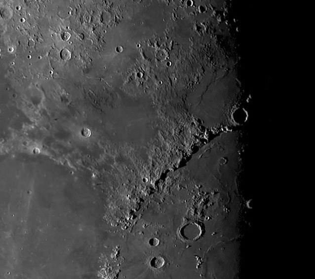
south up image by Maurice Collins, Palmerston North, New Zealand
Maurice has beeen using his new 4.3" refractor to capture mosaics of the entire illuminated Moon and this segment caught my eye. The arc of the Apennine basin rim is classic and usually draws attention inside the rim, but this image made me look outside the rim. Why does only one continuous cross-section of Imbrium's eject deposit remain - the rough textured area between Mare Vaporum and Sinus Aestuum? Aestuum, with Erathosthenes on its shoulder, is a small impact basin, submerged under later lavas, with mare ridges marking an inner rim. Similarly, Vaporum was a depression, and may have also been a small basin. The Imbrium ejecta is missing in those areas because of the basins. But wait, the basins can't possibly be younger than the Imbrium Basin, so if they were there when Imbrium formed, Imbrium ejecta must have been deposited inside them, and then later mare lavas covered it. But there is no suggestion in the basins of a massive amount of ejecta, as seen between the two small basins. It seems unlikely that the basins were so deep that the ejecta is completely hidden under the lavas. The new GRAIL crustal thickness map shows that Aestuum has a very thin crust, only about 10 km thick, and that Vaporum is about 20 km. But these small basins were not likely to have been 10 km or so deep, providing plenty of space for the thick ejecta.... I ran a topographic traverse - using the LRO QuickMap Path altimetry tool - from Imbrium lavas across the top of the Apennines and down the long area of ejecta. I had assumed that the elevation smoothly decreased all the way out that ejecta is visible. But I was astonished to discover that the ejecta elevation flattened out 50 km away from the Apennine Front, which is where the ejecta disappears at Aestuum and Vaporum. So the deposit of ejecta is so thin at Vaporum that it could easily be under the lavas. Aestuum is a different matter - it is right up against the backside of the Imbrium rim and the missing ejecta was about 2 km thick there. That suggests that Aestuum was a deeper basin than Vaporum, or perhaps Aestuum subsided from the weight of lavas that flooded it, carrying the ejecta down out of sight.
Chuck Wood
Technical Details
Jan 20, 2013, 0829-0934UT, WO FLT-110 (4.33" APO) + LPI camera.
Related Links
Rükl plate 33
21st Century Atlas charts 11 & 18..
COMMENTS?
Click on this icon File:PostIcon.jpg at the upper right to post a comment.


