September 13, 2024
Linears
Originally published April 24, 2014

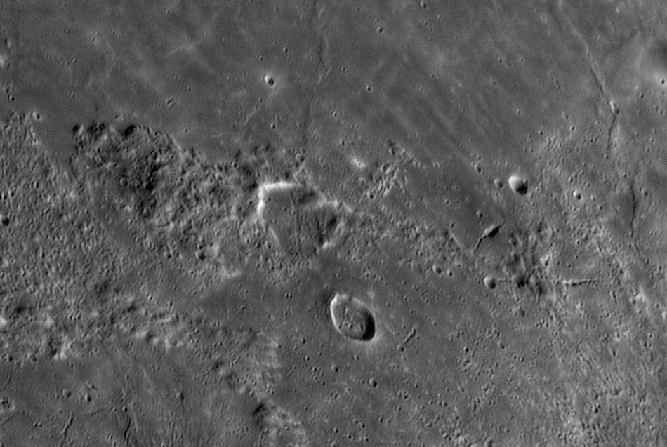
image by Michael Wirths, Baja California, Mexico
This is an area lacking distinctive features, and to save you time looking I'll identify it as the boundary between eastern Mare Frigoris (above) and part of the northeast rim of Lacus Mortis at bottom left. Baily (with only one l) is the rille-crossed crater near the image center, and below it is Baily A, the smaller (diameter of 16 km) crater with a complete rim. It is almost a crime to cut this area from one of Mike's spectacular mosaics, but I was caught by the variety of linear features seen here. Start with Baily itself. A graben-like rille is largely limited to the crater floor, but LRO shows a small continuation on the rough terrain immediately to the north. Undoubtedly, this rille originally continued both to the north and south; the younger Frigoris lavas cover it to the north, as do the older lavas to the south. So the rille, its crater and the ridge of unknown origin it sits on are remnant terrains from an older epoch surrounded by younger materials. At far right-center is another type of linear feature, a crater chain composed of 8 or more pits. Amazingly, this feature is hardly recognizable on the LRO mosaic. From its orientation its parent crater could be Keldysh, about 230 km to the east, but that is not certain. The most interesting semi-linear feature in this scene is the line of small pits with two large volcanic vents in the middle. On a high Sun LRO view this is seen to be the center of a dark deposit, probably resulting from a pyroclastic or ash eruption. Mike's image shows another less conspicuous flat-floored vent just south of the twin one, on a line that is a continuation of the crater chain seen to the east. In fact, the LRO high Sun image does show the crater chain and its continuation thru this new vent. Apparently, it is not a secondary chain but a volcanic chain of pits. The LRO high Sun image reveals another dark area just hinted at here - it is at the west end of the hilly terrain just west of Baily. A LRO high Sun closeup reveals an elongate, smooth-floored vent with a bifurcation at its west end. The various LRO images definitely show more details of these features than the terrestrial view, but details of Mike's image caused me to inspect the LRO view in the first place, and in fact, show the crater chain that was hardly visible to LRO.
Chuck Wood
Technical Details
18" Starmaster dob (driven) Carl Zambuto primary, Zeiss Abbe 3X's barlow, R/IR filter, captured with Firecapture stacked with AS2! and Avisstack2. Seeing: 7-8/10, perfect transparency, 500-600 frames stacked out of 3300 collected. Image scale is 0.13" per pixel.
Related Links
21st Century Atlas chart 9.
Yesterday's LPOD: Polar Volcanism?
Tomorrow's LPOD: Tribute To Image Processing Software Developers
COMMENTS?
Register, Log in, and join in the comments.


