December 26, 2023
Ragged Edge
Originally published December 9, 2013

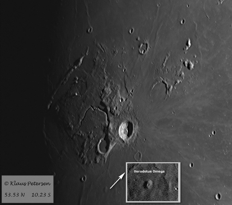
image by Klaus Petersen, Glinde,Germany
I try to find a new story in every LPOD image. The lighting in Klaus' fine image draws my eye to the eastern margin of the Aristarchus Plateau (AP). Often the AP is described as straight-sided, sometimes diamond-shaped. And the northern, western and southern edges are mostly straight, but not the east. A third of the way up the eastern edge of the AP, starting from the southeast corner where Aristarchus sits, is the bright, 8 km wide crater Vaisala, and just to its east is the bathtub-like vent for a sinuous rille. The AP edge here bends westward as if an ancient, half-gone crater cut through the Plateau, and later mare lava filled it. This interpretation is made a little less certain by the existence of the shadow-casting Toscanelli Fault. This could mark the eastern edge of the ancient crater, except the fault continues north beyond a likely crater rim. Whatever caused this depression, it takes a bite out of the AP edge. Further north the AP edge bends a little to the west but not much. But then, Klaus' image shows something that the higher Sun LRO QuickMap view doesn't. Starting at the Aristarchus VIII rille and continuing to Wollaston W, a shadow-filled broad rille segment, there is a peninsula of somewhat elevated and rough-surfaced terrain extending out into the maria. This shows that the AP was not completely fault bounded as an single uplift block on all sides. In fact, the uplift was more widespread and uneven on the east, with isolated mountains extending towards Wollaston, and the more extensive Harbinger Mountains beyond Prinz. It could be that the explanation for all of the vents for sinuous rille along the eastern border is that uplift on this side of AP was discontinuous, providing many breakage paths to the surface. Conceivably, the existence of one giant rille in the middle of the AP is that the AP acted like a solid cap that prevented easy access of mantle rocks to the surface, so mantle material that accumulated under the AP - and uplifted it - found only one vent to the surface - the Cobra Head.
Chuck Wood
Technical Details
16.Jan. 2011 18:33 UT. Meade LX 200 8" f/10, Wratten 25a + DMK21AF04.AS, 500 from 1000 frames stacked with AS!2. Wavelets in Registax6, finished with PS. Seeing 5/10, Transparency 4
Related Links
21st Century Atlas chart 28.
Yesterday's LPOD: Newall Jewel
Tomorrow's LPOD: Just an Artistic View
COMMENTS?
Register, Log in, and join in the comments.


