September 18, 2023
Too Dazzling for Morning Coffee?
Originally published September 3, 2013

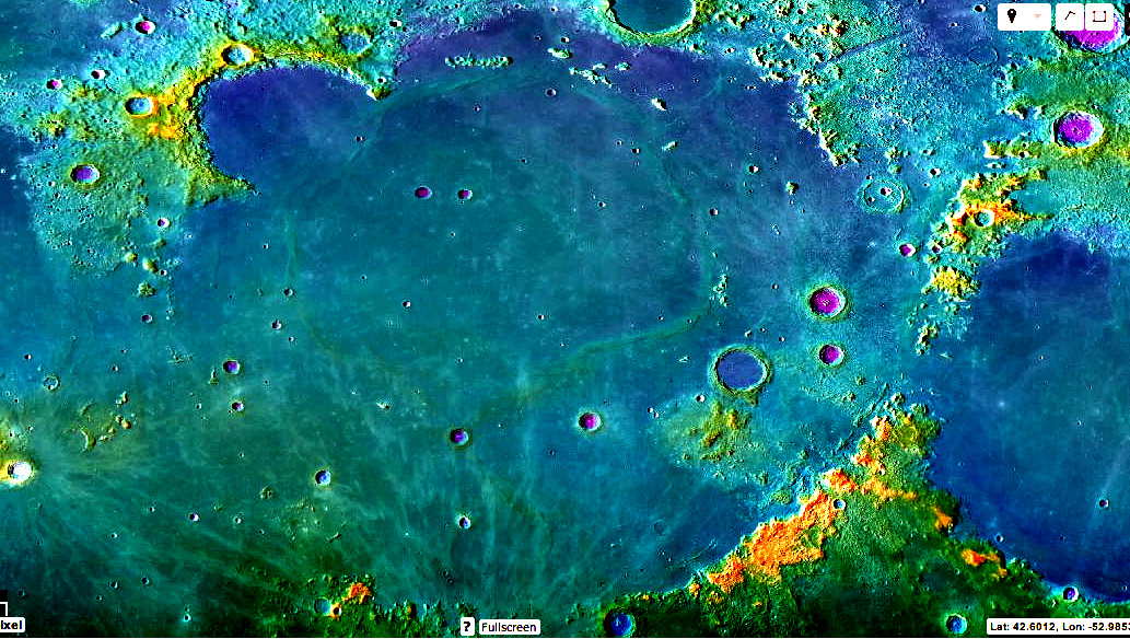
LRO QuickMap image enhanced by Chuck Wood
No, this isn't a false-color regolith chemistry image, but a false-color topography image. I like exaggeration -
it allows me to see more readily things that often hidden away. The standard QuickMap images showing
altimetry are of low contrast (actually bland), especially the blue-green elevations that are the maria. So I
used the PhotoShop Elements commands of Enhance, Adjust Lighting, Levels, followed by Enhance, Unsharp
Mask to saturate the colors to make this image. I like it that the highest parts of the Apennines and the Jura
are bright orange and red, and that deep craters are violet (notice how shallow Plato is?). But the garish colors
are best at bringing out elevation details that were hardly noticeable in the maria. Who appreciated how high
the terrain is around the western end of the Carpathian Mountains? (Why is it?) And notice the strong depiction
of the Grabau to Stille ridges. If you use the QuickMap elevation tool to make a traverse from the dark green
of the mare near the western Carpathians, run it to the middle of Mare Imbrium, and then turn sharply north to
reach the northern floor of Sinus Iridum you will see the topography consistently go downhill from about -1100 m
(below the average lunar radius) to about -2200 in the center of the basin, and to -3000 m where Iridum lavas
meet the Jura Mountains. In fact, all across Imbrium the topography tilts to the north, with the lowest parts of
the basin being not near the center but where the dark blue meets the Jura and northward of the Straight Range
and Teneriffe Mountains. You might think that the whole nearside tilts towards the north, but it doesn't: Crisium
lavas are highest to the north, and in Serenitatis the mare surface is 200-300 m higher in the center than around
the edges. Each mare surface seems to do its own thing, slopewise; I don't know why. It would be very useful if
we could set the color range locally when making altimetry traverses in QuickMap instead of being stuck with
only a limited range of blue-greens for nearly all of the maria!
Chuck Wood
Related Links
21st Century Atlas chart B6.
Yesterday's LPOD: Rillomania
Tomorrow's LPOD: Three Unique Volcanic Centers
COMMENTS?
Register, Log in, and join in the comments.


