May 26, 2023
Updating Smythii
Originally published June 30, 2013

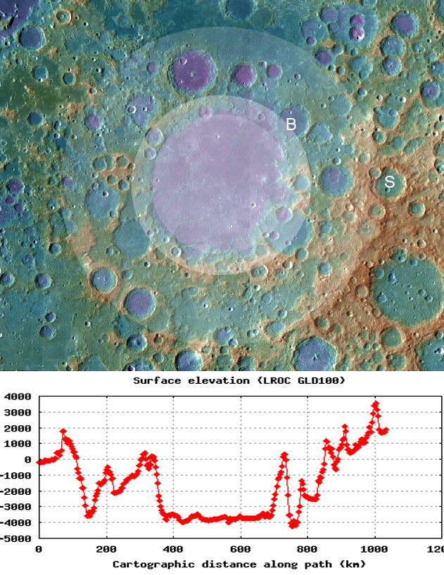
topo image and cross-section from LRO QuickMap (NASA/ASU)
While preparing yesterday's LPOD of Earth-based images of the Smythii Basin I checked the LRO QuickMap and immediately saw an outer basin ring that I don't remember seeing so well before. The ring and two inner ones are defined largely by the topography layer of QuickMap rather than the image itself. I fit circles to the topographic elevations that were ridges or hills rather than crater rims, i.e. topography that could be remnant basin rings. The largest ring is the highest one, is best defined to the southeast, passes through the farside crater Saha and has a diameter of ~900 km. Interior to that is a ~500 km wide ring, easiest seen to the south, and passing through Babcock. An inner ring is not as well defined, but based on the curved western scarp (clearly seen in the bottom image yesterday) a ring about 390 km in diameter can be drawn that marks the edge of the mare quite well. In general, these rings are similar in size to ones measured (360, 660, 840) by Gillis and Spudis in 2000 based on the much lower quality Clementine topographic data. The outer Saha ring is a boundary between heavily cratered, hilly terrain, especially to the east, and inside the ring, lower, smoother, and less cratered material. This area looks like the terrain inside the Altai Scarp at the Nectaris Basin. The extrapolated north boundary of the ring passes near small ridges and hills on the floor of Mare Marginis, evidence that Smythii is younger than the putative Marginis Basin (which may not exist at all). Smythii's inner Mare ring marks the edge of a remarkable elevation difference of 4 km from the top of the scarp to the basin floor. The floor is about 7.5 km below the highest part of the Saha rim. Yesterday's Earth-based images inspired a look at LRO data, resulting in a refinement of knowledge of the basin ring structure - not bad for two LPODs.
Chuck Wood
Related Links
Rükl plate 38
21st Century Atlas charta 2, L2 & B2.
Close-Up Earth View
JJ Gillis & PD Spudis (2000) Geology of the Smythii and Marginis regio of the Moon: Using integrated remotely sensed data. Journal of Geophyscial Research 105, E2, 4217-4233.
Yesterday's LPOD: Keeping Up with the Smythiis
Tomorrow's LPOD: Swirled Pie
COMMENTS?
Register, Log in, and join in the comments.


