March 16, 2023
Upward Holes in the Crust
Originally published April 22, 2013

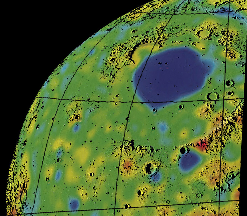
mashup by Maurice Collins, New Zealand
Maurice merged a visualization he made from LRO altimetry data with a crustal thickness mapfrom GRAIL. I asked him to do this because I wanted to see what the blue spots correspond to - and the answer is mostly nothing. The crustal thicknesses range from about 45 km (red) to 40 (gold) to 35 (yellow) to 25 (green) to 15 (light blue) to 10 km (dark blue). The broad blue/thin area within Imbrium's mare ridges reflect the underlying mascon, a combination of thick mare lava and upraised mantle, that further thinned the excavated crust. The blue spot at SInus Aestuum (just south of Eratosthenes) shows that that small basin is a significant mascon too. But what of the smaller blue spot, ringed with circles of lighter blue and green and yellow near Copernicus? There is some misalignment between the crustal and topo maps but the blue is NOT centered on Copernicus, rather that crater is on the edge of completely invisble thin spot - a mini-mascon, a 150 km wide buried crater? A rise of a pod of magma? Between Copernicus and the Imbrium thin area is another smaller blue spot. I first thought that this might overlie Lambert R, a famous circular mare ridge that is all that remains of a mare-covered crater. But the spot isn't there but to the east over a mare ridge. A similar thin spot is just south of Aristarchus - wasn't there an LPOD suggesting a large buried crater there? And finally, notice the blue spot near bottom left in Procellarum. Again there is nothing on the surface to tie this to the thinned crust. Looking at Procellarum and the area south of Imbrium it looks like the boundary between the crust and mantle is like a rolling plain. Yellow thick spots are where the crust sticks down 10 km or so into the mantle, and the blues are places where the mantle/magma rises 10-20 km into the crust. The yellow areas are mostly larger and more irregular than the blue spots, which are circular and like a target with concentric colors. There must be two separate explanations for these ups and downs.
Chuck Wood
Happy Earth Day - don't the greens and blues make you think of home?
Explanation: Here is how yesterday's LPOD was made.
Yesterday's LPOD: Moon Drop
Tomorrow's LPOD: 625 mm
COMMENTS?
Register, Log in, and join in the comments.


