November 30, 2022
Brush Up Your Greek
Originally published January 5, 2013

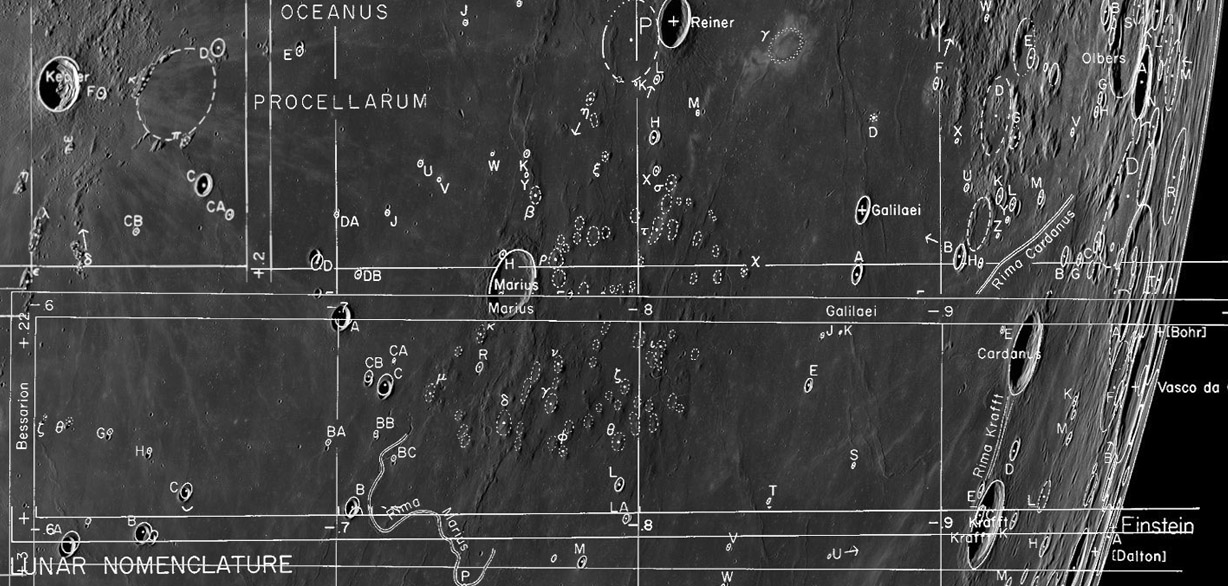
mashup of LRO mosaic and SLC maps by Maurice Collins, New Zealand
50 years ago as an undergrad student with Gerard Kuiper's Lunar and Planetary Lab in Tucson I contributed to the cataloging and mapping of lunar craters. Our work was published in four reports as the System of Lunar Craters (SLC). The International Astronomical Union accepted the nomenclature on the charts as official, but later in 1973 the IAU eliminated the official status of designations of hills and rills. The System is thus the last official nomenclature for features other than craters. I propose that the Greek-lettered designations of hills and Roman numerals for rilles are still valuable. This can be seen in the interesting mashup above of SLC charts and an Lunar Reconnaissance Orbiter mosaic. (As one of the compilers of the charts it is very satisfying to see how well positions and sizes of features compare to the reality of the LRO image.) The Marius Hills have been, and will continue to be, intensely studied because the concentration of volcanic domes and cones is exception on the Moon. The fact that there are so many hills makes it valuable that 16 have once official designations such as Marius Beta and Galilaei Chi. Other useful designations are the 7 Greek letters for peaks near Kepler, and the still officially named Reiner Gamma. I think Greek letter designations for hills and Roman numerals for rilles should be re-established. The first step in doing that is to compile a list of designated hills and rills on the SLC, confirming their positions, sizes and worthiness to have a designation. Maurice's mashup shows how easy it would be to do the hardest part of that process - the identification of exactly which hill the SLC mappers meant to be lettered. Using the LRO QuickMap the positions and sizes of features could be accurate determined. Shall we create a crowd source catalog of lunar hills and rilles?
Chuck Wood
Yesterday's LPOD: Traces
Tomorrow's LPOD: Over the Mountains
COMMENTS?
Register, Log in, and join in the comments.


