August 25, 2022
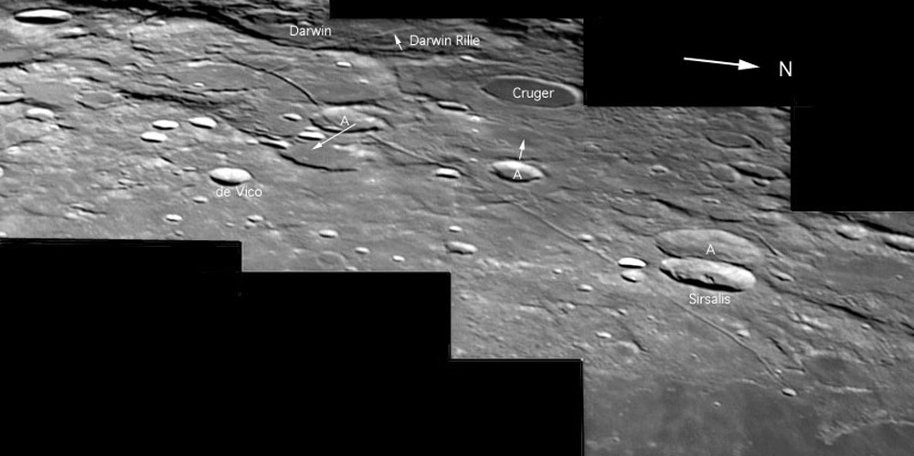
A Rille Draped Across the Landscape
Originally published October 3, 2012

image by K.C. Pau, Hong Kong
Judging by things I have recently read on the Web, there seems to be a lot of misunderstanding about lunar rilles. Different web sites state that the Sirsalis Rille - imaged here by KC Pau - is a lava tube or lava channel, but some admit confusion that such a volcanic feature would form in the lunar highlands rather than on the maria. The word rille is used for a variety of types of troughs that are considerably longer than they are wide. Sinuous rilles (Marius) are volcanic lava tubes and channels. Linear (Ariadaeus) and concentric (Hippalus) rilles are tectonic cracks generally associated with stresses related to impact basins. Linear rilles are interpreted as depressions formed over rising vertical ribbons of magma called dikes. The dikes rise through regions where a horizontal stress is extensional, making it easier for the dike to push aside the surrounding rocks. The Sirsalis Rille is one of the longest linear rilles - about 380 km long. According to work by Jim Head and Lionel Wilson, the rille has a maximum width of 3.7 km and an average depth of 230 m. Combining that data with a measured inward dip of 60 degrees for the rille's sidewalls led head and Wilson to model a dike width of 600-700 m whose top rose from a depth of 300 km to within 2.4 km of the surface. Support for the interpretation as a volcanic dike is provided by magnetic measurements by Apollo and Lunar Prospector which revealed a large linear magnetic anomaly over the dike. The Sirsalis Rille is one of about 8-10 rilles roughly radial to the hypothesized Gargantuan impact basin, whose western third is filled by Oceanus Procellarum. Somehow the dikes are related to the vast Gargantuan depression, but exactly how is uncertain!
Chuck Wood
This is a classic LPOD from 2004
Technical Details
Sep 27, 2004, 15h25~37m (UT); 250mm f/6 Newtonian + 5X barlow; stacked around 52 images for this mosaic.
Related Links
Rükl plate 50
Jim Head and Lionel Wilson (1993) Lunar graben formation due to near-surface deformation accompanying dike emplacement. Planetary and Space Science 41, 719-727.
Yesterday's LPOD: Linear Mystery
Tomorrow's LPOD: Debate Moon
COMMENTS?
Register, Log in, and join in the comments.


