June 7, 2021
Little Yellow Lines
Originally published October 19, 2011

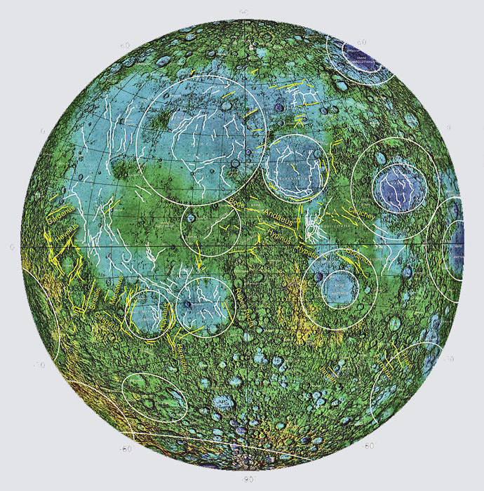
image from Pete Schultz and David Crawford in Recent Advances and Current Research Issues in Lunar Stratigraphy
Linear rilles are often hard to understand. They are commonly modelled as surface fracturing above rising vertical sheets of magma, or dikes. But why do dikes occur where we see rilles? Linear rilles are shown as yellow lines in this map, and as you can see, many are approximately radial to Oceanus Procellarum and some basins. The association with basins suggests that the dikes may be related to magma that rose toward the surface and fed the mare lavas. But Procellarum lavas are generally considered to not fill a large basin so why do so many rilles surround Procellarum? Pete Schultz and David Crawford - who made the map above - provide a speculative explanation related to an oblique impact of the farside South Polar-Aitken Basin. They propose that antipodal stresses established by the SPA impact created a network of magma conduits that fed the nearside maria and localized the dikes feeding them. This is a complicated model which has to be read three or four times to be comprehended. It is intriguingly complex but we can't say if it is right. What the study does indicate is that the location of linear rilles was controlled by global forces not just local accidents of geology.
Chuck Wood
Yesterday's LPOD: Less of a Mystery?
Tomorrow's LPOD: Skimming the Limb
COMMENTS?
Register, Log in, and join in the comments.


