February 19, 2014
Happy B-Day, Copernicus

image by Richard Handy
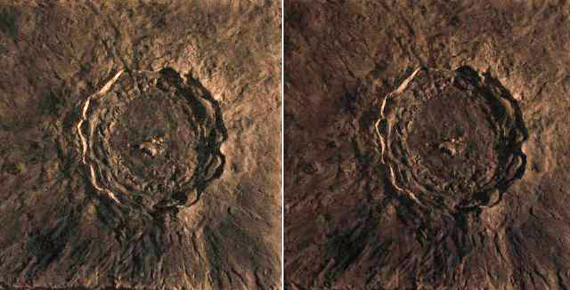
To honor the 541st birthday of Nicolaus Copernicus on the 19th of February, 2014 I decided to sculpt a clay relief model of Copernicus crater. I've been working on the model for a little over a month in order to capture as much detail as possible. I've drawn extensively from the LRO Lunar Orbiter Laser Altimeter (LOLA) elevation data set presented as a color scale to interpret general structural details, but I've also reviewed images from The Kaguya Lunar Atlas by Shirao and Wood, as well as Apollo and LRO and Lunar Orbiter images. The model is 20"x 20" and Copernicus's rim is roughly 9" across. That works out to a scale of one inch equals 10 kilometers. The depth of the model is about 0.4" from rim crest to floor, so the thickness of the clay layer is about 0.250" thick with about another 0.150" built up to form the glacis and highest rims. I took two photos of the model, offset left and right from a baseline so if you can cross your eyes slightly, you can get the two images to merge into a single stereographic view.
The complex crater Copernicus was created about 800 million years ago when an impactor about 1.5 km in diameter, slammed into the western quadrant of the Moon on the eastern edge of Oceanus Procellarum and the southern rim of Mare Imbrium. Though the shape has been described as roughly hexagonal, it is 93 kilometers in diameter measured from rim to rim. It's depth is 3.8 km from rim to floor, a broad 30 km wide glacis surrounds the rim, fanning out onto the mare. Massive slump terraces cascade down onto an impact melt splashed floor whose southern margins are hilly and hummocky. The northeast quadrant is a relatively smooth melt sheet. The slightly offset central peaks are about a kilometer high. Ejected impact melt has pooled on the northern and southern terraces, flowing down the crater walls to the floor. Ejecta were also flung onto the surrounding mare, where the impact created herringbone patterns when it decelerated. Rays of pulverized rock were launched into long arcing trajectories that reached hundreds of kilometers down range. I noted that the LOLA data as well as orbiter images indicate that the southern wall is almost twice as wide as the northern wall and that the central peaks are also offset along this same axis. This seems to suggest that the impactor was traveling from the north to the south when it hit the Moon, although the angle was not so shallow as to create the classic butterfly pattern of rays as seen in craters like Proclus.
Richard Handy
Related Links
21st Century Atlas charts 17 & 22.
An earlier model of Copernicus (probably).
Yesterday's LPOD: Sky Magic
Tomorrow's LPOD: Mountains by the Sea
COMMENTS?
Register, Log in, and join in the comments.


