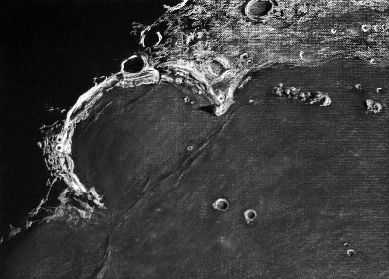
drawing and text by Richard Handy
Less than a several hundred thousand years after the impact that formed the Imbrium basin about 3.8 billion years ago, the 260 km Upper Imbrian age crater formed that would eventually become known to observers as Sinus Iridum, the poetically named Bay of Rainbows. In a blindingly intense blast lasting less than a couple of seconds, the roughly 13 km Iridum asteriod gouged out a section of one of the ejecta rings that surrounded the Imbrium basin, scattering a rubbly circular lens of debris around the crater. It’s floor was lower in depth to the south, where it intersected the plate shaped lowlands of the basin. Huge chuncks of ejecta covered or partially obliterated the older craters that had survived the Imbrium event, giving Nectarian aged 48 km Maupertuis on it’s northeast slopes an odd rhomboidal shape. Thirty seven km Lower Imbrium crater La Condamine to the north seems to have faired a little better, partially filled with Iridum ejecta. 24 km Bouguer to its west is the the most recent, of Copernician age. To the northwest it pushed up the rim creating the Jura mountains, in places 6000 meters high. Even though the Imbrium basin had been flooding for a few hundred thousand years, and the mare basalts had not yet reached the lower elevations of the southern rim of the Iridum crater, it seems likely that Iridum’s floor had already been weeping a slow flow of lava from fissures that had been opened up by the force of the fiery impact. Still it would be close to half a billion years before the Imbrium flows began to erode the southern peaks and cascade down the slopes to completely cover the crater floor. As the lower southern floor began to subside from the load of dense basalt, the whole southern rim section may have suffered a series of catastrophic slides further down into the Imbrium basin, producing the clean separation at the 2600 meter high Promontorium Laplace, the eastern cape. Now only the sinuous dorsae near the craterlet Laplace A mark the rim’s southern boundry. To the west, the Promontorium Heraclides, Cassini’s aptly named “Moon Maiden”, reaches a height of 1700 meters, yet the western cape seems to taper to the southwest, blending rather smoothly into the mare. Along with its slow liquid inundation, Iridum was struck by several small impacts, most notably 39 km Upper age Imbrian Bianchini which apparently caused a section of the northern rim to collapse, creating a talus of regolith beneath it’s southern rampart as a result of the seismic shock imparted so close to the rim of Iridum. Beyond the capes to the southwest are the 26 km Imbrium aged crater Helicon and it’s smaller companion, 20 km Eratosthenian Le Verrier. Out on the mare, to the west of Promontorium Laplace, is Montes Recti, a rectangular group of mountains 94 km long x 12 km wide, at 1800 meters, towering over the surrounding somber lava plains.
Rich Handy
Technical Details
Subject: Sinus Iridum #14 of L100 Rukl: 2, 3, 10 , 11
Time: 4:47 UT till 6:10 UT Date: July 25, 2007
Seeing: Antoniadi III -II Weather: clear and calm
Lunation: 10.7 days
Colongitude: 35.8 deg.
Illumination: 76.8%
Lib. in Lat.: +07 deg. 31 min.
Lib. in Long.: -03 deg. 28 min.
Phase: 57.6 deg.
Telescope: 12″ Meade SCT f/10
Binoviewer: W.O. Bino-P with 1.6X nosepiece
45 deg. W.O. erect image diagonal
Eyepieces: 18mm W.O. Plossls
Magnification: 271X
Sketch Medium: White and black Conte’ crayon on black textured
Strathmore
paper
Sketch size: 18″ X 24″
Related Links:
Rükl plate 10
Another view
Yesterday's LPOD: Small Spectacular
Tomorrow's LPOD: A Classic Returns
COMMENTS?
Register, Log in, and join in the comments.


