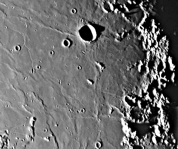
image by Jérôme Grenier
Lunar sinuous rilles are lava channels. They did not cut down into pre-existing surfaces, rather they transported the lava that formed the surrounding surfaces. Sinuous rilles were once rivers of molten lava, now they are elusive channels of emptiness. The Maskelyne Channel, opps, I mean Rille, is a little-viewed, dried lava river that traverses southern Mare Tranquillitatis. The Apollo 11 crew called this the Diamondback Rille. Its northern end is the widest and deepest part and it appears to start at a double crater just west of Maskelyne X. But as Jérôme’s wonderful image shows, the rille bypasses that apparent source and continues to wind its way further south, stopping near Censorinus K (Rükl 47). In its middle stretch the rille is apparently shallow, but that might be because it is less perpendicular to the lighting than its end segments. Near its northern end the rille branches, with a short straight segment passing close to the crater Maskelyne G. The opposite side of the main rille from the branch is a straight narrow ridge and a series of touching pits – secondary craters or volcanic collapse pits? Jérôme’s image - and the Apollo one linked below - demonstrate that mare surfaces are quite complex when seen from orbit or with a good amateur telescope!
Technical Details:
09 Sept 2004, 8″ SCT Meade + Atik BW camera + red 23a filter. Jérôme submitted an image with excellent tonal range; CAW exaggerated the enhancement to make the rille more visible.
Related Links:
Rükl chart 36 & 47
Jérôme’s Website
Jim Phillips’ view of Diamondback Rille
Apollo 11 view
Yesterday's LPOD: Draped Landscapes
Tomorrow's LPOD: Look Ma. No Lines!
COMMENTS?
Register, Log in, and join in the comments.


