May 21, 2014
Ground Penetrating Radar - an Extraterrestrial View

image from Bruce Campbell (Smithsonian Institution, National Air and Space Museum); Arecibo/NAIC; NRAO/AUI/NSF
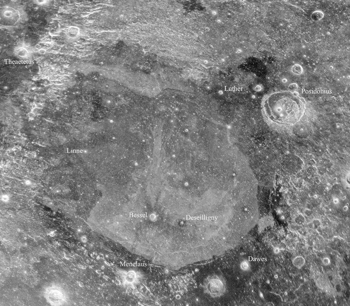
LPOD has featured many radar images of the Moon, always showing features differently than we see them with normal images where light bounces off the top microns of the surface. This image, captured using two radio telescopes, reveals unknown features 10 to 15 m below the surface of Mare Serenitatis. The 305 m Arecibo telescope in Puerto Rico sent pulses of radio waves to the Moon, where they hit the surface and penetrated it, before bouncing back to the Earth and into the 100 m wide maw of the Green Bank telescope here in West Virginia. The first thing that draws attention is the razor sharp boundary between the dark lavas around the edges of Mare Serenitatis and the lighter hued ones inside. The darkest lavas are near the Sulpicius Gallus Rilles at extreme left, the Apollo 17 area at the right, and an unexpected area north of Luther at top right. More of a detail are the dark halos around Bessel and Deseilligny, whose ejecta brought up the annular dark lavas which must underlie the lighter lavas. But what is most astonishing to me is the long flow that seems to emanate from Bessel and travel about 235 km due north. This is not a radar version of the famous Bessel ray which angles towards Luther. Nor is it a subsurface manifestation of the mare ridge that passes immediately east of the flow. There is no surface evidence for this flow on LRO images. I can imagine that this is a lava flow that is completely covered by a later one, but I am surprised by two things. That is seems to come from near Bessel and that it is much more sharply defined than the lavas that cover it. But perhaps the vent area is north of Bessel where a line of dark features passes from east to west. In this interpretation a wide flow from the linear vents dwindled as it flowed south towards Bessel, and another broader flow travelled east, north of Deseilligny - notice how its eastern end is rounded. Another possible flow apparently came out of a fractured part of the Caucasus Mountains east of Theaetetus and travelled eastward almost to Luther. I am not certain that this is a flow and don't know why there is a narrow dark band along its southern edge. These two flow-like features and many other intriguing landforms in this wonderful image require much more study before we can understand them. But now we know they are there.
Chuck Wood
Related Links
21st Century Atlas charts 8 & 11.


