Difference between revisions of "November 6, 2009"
(Created page with "__NOTOC__ =New Data, New Answers, New Mysteries= <!-- ws:start:WikiTextHeadingRule:0:<h1> --> <!-- ws:start:WikiTextLocalImageRule:6:<img src="/file/view/LPO...") |
|||
| Line 4: | Line 4: | ||
<!-- ws:start:WikiTextHeadingRule:0:<h1> --> | <!-- ws:start:WikiTextHeadingRule:0:<h1> --> | ||
<!-- ws:start:WikiTextLocalImageRule:6:<img src="/file/view/LPOD-Nov6-09.jpg/100656609/LPOD-Nov6-09.jpg" alt="" title="" /> -->[[File:LPOD-Nov6-09.jpg|LPOD-Nov6-09.jpg]]<!-- ws:end:WikiTextLocalImageRule:6 --><br /> | <!-- ws:start:WikiTextLocalImageRule:6:<img src="/file/view/LPOD-Nov6-09.jpg/100656609/LPOD-Nov6-09.jpg" alt="" title="" /> -->[[File:LPOD-Nov6-09.jpg|LPOD-Nov6-09.jpg]]<!-- ws:end:WikiTextLocalImageRule:6 --><br /> | ||
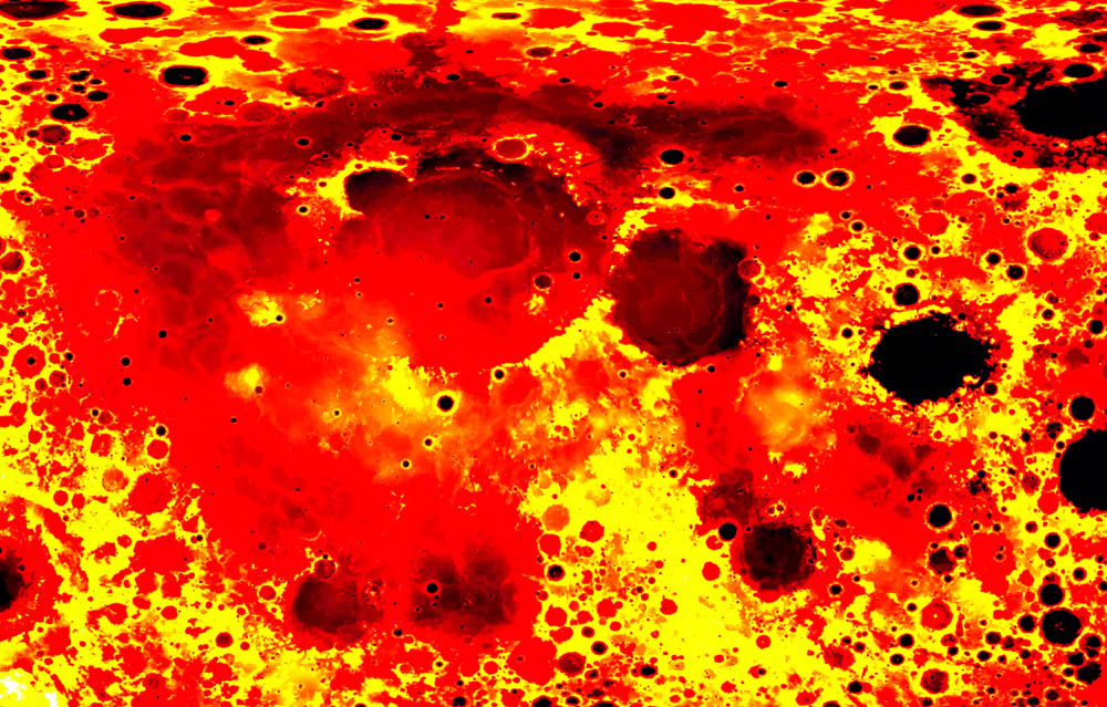
| − | <em>Kaguya topographic data processed by Doug Ellison and found on Emily Lakdawalla's [mailto:tychocrater@yahoo.com Chuck Wood]<br /> | + | <em>Kaguya topographic data processed by Doug Ellison and found on Emily Lakdawalla's [http://www.planetary.org/blog/article/00002191/ blog]</em><br /> |
| + | <br /> | ||
| + | The Kaguya data have been [https://www.soac.selene.isas.jaxa.jp/archive/ released]. It is difficult to understand how to access it but Doug Ellison and other members of the [http://www.unmannedspaceflight.com/index.php?showtopic=6281&st=30 unmannedspaceflight.com] group of image processing wizards have succeeded in unlocking the topography data set. I have taken Doug's rendition on Emily's blog and enhanced the devil out of it to better reveal topographic variation in low areas. In this version yellow is high terrain, red is the general mare level and black is very low terrain. I am interested in the shades of gray that occur in various mare areas, If you look at Imbrium, you can see an answer to an observation mystery that has vexed me for decades. The famous young Imbrium lava [http://www.lpod.org/archive/LPOD-2004-07-19.htm flows] start in the western part of the basin, flow towards the center and then turn to the north. I expected that the center part of Imbrium would be its lowest part so flowing northward away from the center should be uphill. But we now see that it is not. The entire northern arc of Imbrium is low - the lava flows followed gravity downhill to the north. It is quite surprising that Imbrium slopes so persistently from south to north. And look at Frigoris - it is lower than the comparable circumferential lavas (Sinus Medii, Mare Vaporum and Sinus Aestuum) to the south of Imbrium. Why are the surfaces of Frigoris, northern Imbrium and northern Procellarum so much lower than their southern counterparts? There are many other things to investigate. Notice the topographic evidence for the Nubium Basin and the depression northwest of Nectaris suggests an undetected basin under Sinus Asperitatis. Finally, note that the lowest part of [http://lpod.wikispaces.com/April+29%2C+2009 Petavius] - near bottom right - is a ring around the edge of its floor - further evidence that its center has been uplifted. <br /> | ||
| + | <br /> | ||
| + | <em>[mailto:tychocrater@yahoo.com Chuck Wood]<br /> | ||
Thanks to Doug - who I don't know - and Emily!</em><br /> | Thanks to Doug - who I don't know - and Emily!</em><br /> | ||
<br /> | <br /> | ||
Revision as of 19:48, 1 January 2015
New Data, New Answers, New Mysteries
Kaguya topographic data processed by Doug Ellison and found on Emily Lakdawalla's blog
The Kaguya data have been released. It is difficult to understand how to access it but Doug Ellison and other members of the unmannedspaceflight.com group of image processing wizards have succeeded in unlocking the topography data set. I have taken Doug's rendition on Emily's blog and enhanced the devil out of it to better reveal topographic variation in low areas. In this version yellow is high terrain, red is the general mare level and black is very low terrain. I am interested in the shades of gray that occur in various mare areas, If you look at Imbrium, you can see an answer to an observation mystery that has vexed me for decades. The famous young Imbrium lava flows start in the western part of the basin, flow towards the center and then turn to the north. I expected that the center part of Imbrium would be its lowest part so flowing northward away from the center should be uphill. But we now see that it is not. The entire northern arc of Imbrium is low - the lava flows followed gravity downhill to the north. It is quite surprising that Imbrium slopes so persistently from south to north. And look at Frigoris - it is lower than the comparable circumferential lavas (Sinus Medii, Mare Vaporum and Sinus Aestuum) to the south of Imbrium. Why are the surfaces of Frigoris, northern Imbrium and northern Procellarum so much lower than their southern counterparts? There are many other things to investigate. Notice the topographic evidence for the Nubium Basin and the depression northwest of Nectaris suggests an undetected basin under Sinus Asperitatis. Finally, note that the lowest part of Petavius - near bottom right - is a ring around the edge of its floor - further evidence that its center has been uplifted.
Chuck Wood
Thanks to Doug - who I don't know - and Emily!
COMMENTS?
Click on this icon File:PostIcon.jpg at the upper right to post a comment.


