Difference between revisions of "September 12, 2009"
(Created page with "__NOTOC__ =A Dry Hole?= <!-- ws:start:WikiTextHeadingRule:0:<h1> --> <!-- ws:start:WikiTextLocalImageRule:6:<img src="/file/view/LPOD-Sept12-09.jpg/88422969/...") |
|||
| Line 4: | Line 4: | ||
<!-- ws:start:WikiTextHeadingRule:0:<h1> --> | <!-- ws:start:WikiTextHeadingRule:0:<h1> --> | ||
<!-- ws:start:WikiTextLocalImageRule:6:<img src="/file/view/LPOD-Sept12-09.jpg/88422969/LPOD-Sept12-09.jpg" alt="" title="" /> -->[[File:LPOD-Sept12-09.jpg|LPOD-Sept12-09.jpg]]<!-- ws:end:WikiTextLocalImageRule:6 --><br /> | <!-- ws:start:WikiTextLocalImageRule:6:<img src="/file/view/LPOD-Sept12-09.jpg/88422969/LPOD-Sept12-09.jpg" alt="" title="" /> -->[[File:LPOD-Sept12-09.jpg|LPOD-Sept12-09.jpg]]<!-- ws:end:WikiTextLocalImageRule:6 --><br /> | ||
| − | <em>image from [mailto:tychocrater@yahoo.com Chuck Wood]</em><br /> | + | <em>image from [http://www.nasa.gov/mission_pages/LCROSS/main/LCROSS_crater.html NASA LCROSS webpage], showing "potential water concentrations".</em><br /> |
| + | <br /> | ||
| + | I am confused by NASA's selection of Cabeus A as the target for the LCROSS impact of October 9. According to the NASA [http://www.nasa.gov/mission_pages/LCROSS/main/LCROSS_crater.html press release] Cabeus A was selected based on <em>a set of conditions that include proper debris plume illumination for visibility from Earth, a high concentration of hydrogen, and mature crater features such as a flat floor, gentle slopes and the absence of large boulders.</em> The crater is on the Earthward side of the pole so it is more visible than one closer to the farside, and it is an old eroded crater with gentle topography. But the image above, from the press release, and labeled only with the simple caption, <em>Potential South Pole Water Concentrations</em> indicates that there is NO WATER there. What am I missing? The sole purpose of LCROSS is to try to unambiguously detect water on the Moon by impacting within a permanently shadowed crater near the poles. But at least half of Cabeus A is visible in Lunar Orbiter IV [http://www.lpi.usra.edu/resources/lunar_orbiter/images/aimg/iv_193_h1.jpg images], where the illumination is supplied by sunlight. Am I misreading the graph? Is there a more technical explanation somewhere? <br /> | ||
| + | I have just found a statement on NASA's [http://lcross.arc.nasa.gov/observation.htm observers page] that the <em>sweet spot</em> - where water is most likely to be - is in the shadowed area of the small crater on the left rim of A that is labelled A1 on a photo on the observers page. It looks like the 2 pixel wide shadowed area has a potential water content of about 1.5%. But why not select Cabeus B, the larger, flat floor crater just to the bottom left of the yellow circle? At least part of this floor is predicted to have 1% water and the larger floor is an easier target; hitting the walls of A or A1 will be unlikely to find water, for downslope movement would probably long ago have carried any water ice to the crater's small floor. I hope the aim is good.<br /> | ||
| + | <br /> | ||
| + | <em>[mailto:tychocrater@yahoo.com Chuck Wood]</em><br /> | ||
<br /> | <br /> | ||
<strong>Related Links</strong><br /> | <strong>Related Links</strong><br /> | ||
Revision as of 19:46, 1 January 2015
A Dry Hole?
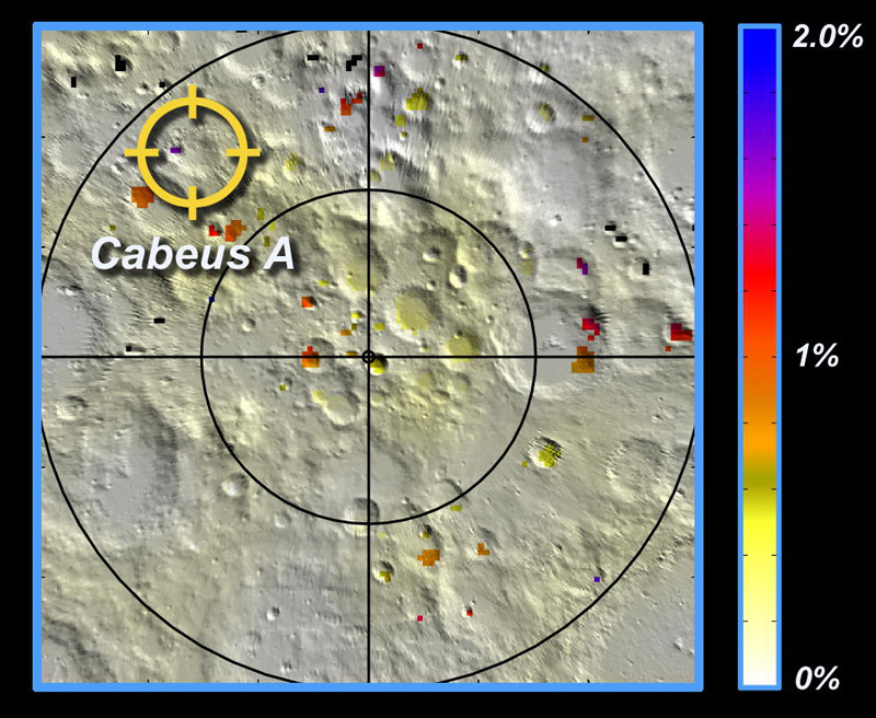
image from NASA LCROSS webpage, showing "potential water concentrations".
I am confused by NASA's selection of Cabeus A as the target for the LCROSS impact of October 9. According to the NASA press release Cabeus A was selected based on a set of conditions that include proper debris plume illumination for visibility from Earth, a high concentration of hydrogen, and mature crater features such as a flat floor, gentle slopes and the absence of large boulders. The crater is on the Earthward side of the pole so it is more visible than one closer to the farside, and it is an old eroded crater with gentle topography. But the image above, from the press release, and labeled only with the simple caption, Potential South Pole Water Concentrations indicates that there is NO WATER there. What am I missing? The sole purpose of LCROSS is to try to unambiguously detect water on the Moon by impacting within a permanently shadowed crater near the poles. But at least half of Cabeus A is visible in Lunar Orbiter IV images, where the illumination is supplied by sunlight. Am I misreading the graph? Is there a more technical explanation somewhere?
I have just found a statement on NASA's observers page that the sweet spot - where water is most likely to be - is in the shadowed area of the small crater on the left rim of A that is labelled A1 on a photo on the observers page. It looks like the 2 pixel wide shadowed area has a potential water content of about 1.5%. But why not select Cabeus B, the larger, flat floor crater just to the bottom left of the yellow circle? At least part of this floor is predicted to have 1% water and the larger floor is an easier target; hitting the walls of A or A1 will be unlikely to find water, for downslope movement would probably long ago have carried any water ice to the crater's small floor. I hope the aim is good.
Chuck Wood
Related Links
Rükl plate 72
A YouTube video of the impact site. Wonder who made it?
COMMENTS?
Click on this icon File:PostIcon.jpg at the upper right to post a comment.


