Difference between revisions of "March 22, 2012"
(Created page with "__NOTOC__ =Two-Fer= <!-- ws:start:WikiTextHeadingRule:0:<h1> --> <em>image by [mailto:howardeskildsen@msn.com Howard Eskildsen], Address: small freighter, big ocean...") |
(No difference)
|
Revision as of 17:53, 1 January 2015
Two-Fer
image by Howard Eskildsen, Address: small freighter, big ocean!
Only a dedicated lunar observer would send images while on vacation. Here is what Howard wrote: Greetings from the South Pacific. Took this photo of the Moon yesterday AM somewhere south of Fatu Hiva in the Marquesas. The old crescent Moon smiled on another day at sea from the constellation of Pisces. Strange to see it so high in the sky. We are about 10 degrees south latitude.
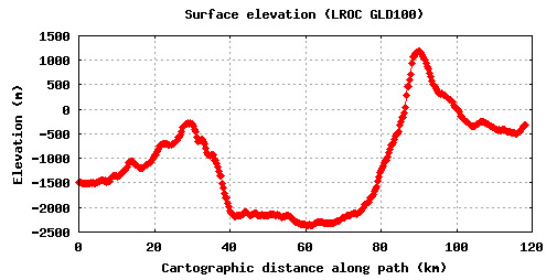
Let's switch now to a continuing discussion of the topographic measurements from yesterday's LPOD. In the comment section WK Gourley asked if the LRO altimetry tool could be used on any image, such as the wonderful one from Mario. The answer is no, only the LRO Quick Map mosaic can be used because the altimetry data is mapped, pixel by pixel to it. While the mosaic has high resolution it also has relatively high illumination so that many low-slope features such as domes and mare ridges can not be easily detected. I assume/hope that the LRO team will create another mosaic with low Sun views so that users of Quick Map could select either the current or a low illumination image. That would make pinpointing of low features easier for measurements with the topo tool (and it would be great to have two views for image interpretation). It would also be nice if a series of lines of the profiles measured could be saved onto the mosaic - I had to use PhotoShop Elements to add the lines and elevations of the measurements on Mario's image. In an email, Patricio Leon also corrected my measurement of Thebit, which I gave as 1,290 m; he pointed out that it is more like 3,290 m. Actually, the depth depends on the particular cross-section measured (but 1,290 m isn't correct anywhere). The diagram, showing a roughly west to east profile across Thebit, demonstrates that the rim is much lower on the west than on the east, but interestingly the floor doesn't tilt similarly. The new LRO topo tool is showing repeatly that elevations aren't the way we thought they were.
Chuck Wood

Technical Details
Howard's image: March 20, 2012, 15:56 UT.
COMMENTS?
Click on this icon File:PostIcon.jpg at the upper right to post a comment.


