Difference between revisions of "August 22, 2019"
(Created page with "__NOTOC__ =Find the Crater= Originally published May 11, 2010 <!-- Start of content --> <!-- ws:start:WikiTextHeadingRule:1:<h1> --> <!-- ws:start:WikiTextLocalImag...") |
(No difference)
|
Latest revision as of 00:05, 22 August 2019
Find the Crater
Originally published May 11, 2010

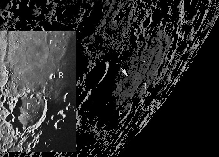
left image from CLA F9and right LOLA DTM processed by Maurice Collins. F = Fracastorius, R = Rosse, and r = ridge.
With every new data set, new things are discovered. Maurice, the explorer of high-res altimetry data, has noticed a dimple near the center of Mare Nectaris. It is to the northwest of Rosse, with an arrow pointing to it. There are two questions - is it real and what is the explanation? In looking at a variety of telescopic images - the best one being the Consolidated Lunar Atlas insert above left - there seems to be little evidence for its existence. But the digital terrain model (DTM) with only one half degree illumination does seem relatively convincing. As to what it is, my first thought was perhaps an inner basin ring, but it is off-center and too small. I wonder if it is an impact crater that formed on the floor of the newly formed basin and later was completely inundated by mare lavas. The thickness of the Nectaris lava is estimated to be about 1 km, just barely enough to cover a crater like this. So it is possible and I guess likely, that that is the explanation. Until other evidence shows up to suggest otherwise.
Chuck Wood
Technical Details
LRO LOLA data processed with LTVT.
Related Links
Rükl plate 58
Yesterday's LPOD: No Stratton
Tomorrow's LPOD: Real Zoo
COMMENTS?
Register, Log in, and join in the comments.


