Difference between revisions of "September 30, 2009"
| Line 12: | Line 12: | ||
<br /> | <br /> | ||
<strong>Technical Details</strong><br /> | <strong>Technical Details</strong><br /> | ||
| − | This image appears to be from the [https://the-moon.us/wiki/Cornell- | + | This image appears to be from the [https://the-moon.us/wiki/Cornell-Smithsonian_Radar_Mosaic Cornell-Smithsonian Radar Mosaic]<br /> |
<br /> | <br /> | ||
<strong>Related Links</strong><br /> | <strong>Related Links</strong><br /> | ||
| − | Rükl plate [https://the-moon.us/wiki/R%C3% | + | Rükl plate [https://the-moon.us/wiki/R%C3%BCkl_72 72]<br /> |
<br /> | <br /> | ||
<p><b>Yesterday's LPOD:</b> [[September 24, 2009|Happy Trails]] </p> | <p><b>Yesterday's LPOD:</b> [[September 24, 2009|Happy Trails]] </p> | ||
Latest revision as of 17:57, 13 October 2018
A Wetter Hole?

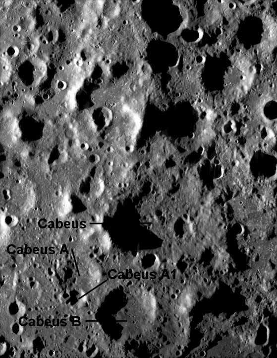
unidentified radar image from LCROSS Ground and Space Based Observations (South Pole to right)
Nine days from now the Lunar Crater Observing and Sensing Satellite (LCROSS) will impact the Moon, aiming at a new target. On September 11 NASA announced that the site selected in the attempt for a positive identification of water would be a small crater on the rim of Cabeus A, informally labelled A1. But although "A1" usually means "the very best", that target seemed to not be the best and LPOD recommended that a larger crater with a higher chance of success be targeted. Now NASA has just announced that they have changed the LCROSS target, not to the LPOD recommended Cabeus B but to Cabeus itself. This is a great improvement, made in response to new topographic data from the Lunar Reconnaissance Orbiter and continuing analysis of existing Kaguya, Chandrayaan-1 and Lunar Prospector data. I wish the LCROSS team had supplied more details about their reasoning, for Cabeus may not even be a crater - if it is it is very old and ruined, and appears to have only one tall rim segment to block solar illumination. Currently the team expects to refine the exact site for the impact to find a smooth part of the floor. That might be difficult, for as seen in the radar image above the floor of Cabeus appears substantially rougher that the floors of Cabeius A (not A1), B and other nearby craters. The previously published map of likely hydrogen concentrations (H is thought to be a proxy for water) shows that both Cabeus and Cabeus B have similar areas with projected 1.0 to 1.5 hydrogen abundances and both are better targets than Cabeus A1. Despite the recent announcements of water detection the LCROSS mission is high risk - there are many reasons why a non-detection might occur - but success will be a stunning confirmation of polar water, a powerful stimulus for continued lunar exploration.
Chuck Wood
Note: We are back from Ireland, having had great hospitality from Frank, Simon, Stephen and others of the Shannonside Astronomy Club - thanks all!
Technical Details
This image appears to be from the Cornell-Smithsonian Radar Mosaic
Related Links
Rükl plate 72
Yesterday's LPOD: Happy Trails
Tomorrow's LPOD: Chasing Cryptomaria
COMMENTS?
Register, Log in, and join in the comments.


