Difference between revisions of "October 13, 2018"
(Created page with "__NOTOC__ =I'll Drink To That= Originally published July 30, 2009 <!-- Start of content --> <!-- ws:start:WikiTextHeadingRule:2:<h1> --> <!-- ws:start:WikiTextLocal...") |
(No difference)
|
Latest revision as of 00:04, 13 October 2018
I'll Drink To That
Originally published July 30, 2009

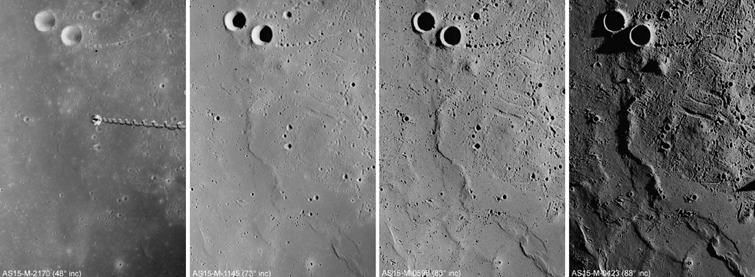
image from The Planetary Society Blog and ultimately NASA / JSC / Arizona State University
Sam Lawrence, a post doc with the enviable job of working with new images from LRO, has recently compared the way the lunar surface looks under four different illuminations. He used these ancient Metric Camera images from Apollo 15 to capture the dramatic changes in the appearance of the same location as the Sun angle decreases from 42° to 17°, to 7°, and finally to a very grazing 2° above the surface. Sam discusses these images in terms of their usefulness in selecting a safe landing site, but they are also very instructive in how they provide complementary information about the surface. The high Sun view at left is full of tonal variations due to the differences is albedo of younger and older lava flows. The high Sun view is also the only way we can see the bottoms of small craters (top left) and is the easiest way to detect rays and nimbii around very fresh craters (bottom center). The decrease in illumination angle by 25° (going to the second image from the left) does not result in significant changes to what we can see. Yes, the mare ridge and some texture to the upper right - including a possible dome - become visible, but it is not a dramatic change. Dropping the Sun down another 10° (3rd image) improves the interpretability and would provide quite a lot of detail to analyse. But after seeing the last image, where the Sun's photons came screeching across the surface only 2° above the horizon, is what I'd would want to spend my time on. It transforms a relatively flat-looking and bland surface of the first two images into a fascinating terrain of ridges, swells, secondaries, and rille segments that bespeak a complex geologic history that can be both detected and interpreted. As observers and imagers we can't always get good seeing when a feature we want is close to the terminator, but acquire images what ever the lighting, whenever the seeing is good. Although this sequence suggests the lowest Sun image is best for interpretation of morphology, application of an unsharp mask filter to the other three images will bring them closer to the low Sun view.
Chuck Wood
Technical Details
Can you identify this region? The Rükl link below will get you into the field of view, but what are the two biggest craters?
Related Links
Rükl plate 21
Yesterday's LPOD: Rules for Rilles
Tomorrow's LPOD: 27 & 28
COMMENTS?
Register, Log in, and join in the comments.


