Difference between revisions of "October 10, 2018"
| Line 12: | Line 12: | ||
<br /> | <br /> | ||
<strong>Technical Details</strong><br /> | <strong>Technical Details</strong><br /> | ||
| − | The de Gasparis rilles were first designated by [https://the-moon.us/wiki/ | + | The de Gasparis rilles were first designated by [https://the-moon.us/wiki/Neison_-_Map_15 Neison], and the <em>NLF</em> catalog includes them but they do not appear on the accompanying maps.<br /> |
<br /> | <br /> | ||
<strong>Related Links</strong><br /> | <strong>Related Links</strong><br /> | ||
Latest revision as of 04:39, 10 October 2018
Rilles - a New Look
Originally published July 27, 2009

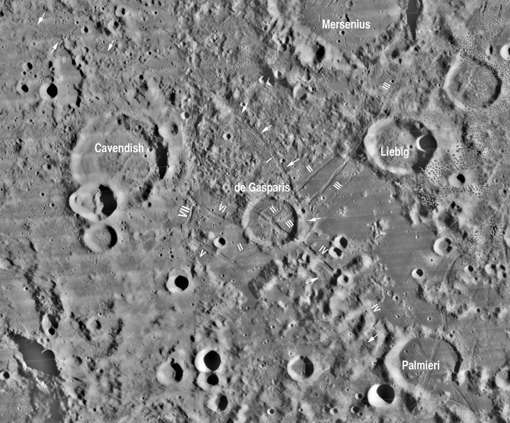
Lunar Orbiter IV mosaic from USGS Map-A-Planet with annotations by Chuck Wood
As we acquire new high resolution images of the entire Moon and actually plan for humans to return, there are both the resources and the need to update lunar nomenclature. Jenny Blue at the USGS has nearly completed her compilation of the best nomenclature map ever made, including named and lettered craters. But the Moon has many other types of landforms that will be increasingly discussed and thus need designations to facilitate clear communication. Sadly, all of the peaks and rilles that had International Astronomical Union-approved Greek letters and Roman numeral designations from 1935 and again in the early 1960s were eliminated in the early 1970s and never resurrected. Part of the reason is that the 1935 Blagg and Muller catalog, Named Lunar Formations (NLF), which included non-crater features, had never been updated even though the System of Lunar Craters (SLC) maps of the 60s contained thoroughly updated depictions and nomenclature for such features. This LPOD presents an example of how lunar rille nomenclature can and should be re-examined. The area west of Mare Humorum is rich with rilles, and map sheet F6 of SLC contains many rilles with numeral designations. One group is centered on De Gasparis from which rilles extend in nearly every direction. I have labelled each of the four numbered rilles from the SLC map - which was the last IAU-approved rille nomclature - and have added rille V, which clearly is separate from the cross-cutting rille II. Additionally, I also renamed two rilles as de Gasparis VI and VII (which previously were labelled Cavendish I and II) for they seem structurally and spatially part of the de Gasparis family. In researching the de Gasparis rilles I discovered that rille I (marked with arrowheads) appears to extend considerably to the west and all the way to Palmieri to the east. The rille is not everywhere continuous (especially to the west) but appears to be one very long single structure. It also appears that de Gasparis IV bends sharply and continues across the floor of Palmieri. Lunar scientists do not understand why these two craters are the centers of crossing rilles, but even a mundane task such as checking nomenclature increases awareness of such interesting problems. Note that this nomenclature is only an experiment, and some people will be unpleased that numbers and names are suggested to be changed. But that is what happens every time nomenclature is re-examined in light of new images and understanding.
Chuck Wood
Technical Details
The de Gasparis rilles were first designated by Neison, and the NLF catalog includes them but they do not appear on the accompanying maps.
Related Links
Rükl plate 51
Yesterday's LPOD: Crater Systematics
Tomorrow's LPOD: South Pole Unwarped
COMMENTS?
Register, Log in, and join in the comments.


