Difference between revisions of "March 4, 2016"
(Created page with "__NOTOC__ =NOT the Source of Lunar Nomenclature= Originally published May 9, 2005 <!-- Start of content --> <table width="85%" border="0" align="center" cellpadding="6" cells...") |
(No difference)
|
Latest revision as of 01:04, 4 March 2016
NOT the Source of Lunar Nomenclature
Originally published May 9, 2005
Image Credit: Hevelius and The U.S. Naval Observatory Library |
|
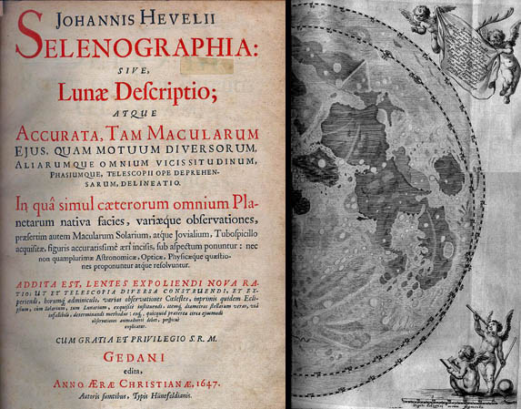
NOT the Source of Lunar Nomenclature In 1647, Johannes Hevelius made the second major chart of the Moon that showed and named identifiable features - Langrenus was first in 1645. Using a 12 ft long, 50 power telescope Hevelius made three maps - including a full Moon view - the eastern half of which is seen here. The double rim demonstrates that Hevelius recognized and mapped the effects of libration. Hevelius named 286 craters, mountains and maria, but only 10 of his names, including the Alpes and Apennines, are still used. Hevelius names were long and cumbersome; more significantly, four years later Grimaldis map appeared with the simplifed nomnclature of Riccioli. These are the hundreds of names we know today: Copernicus, Plato, Ptolemaeus, and most of the others. Related Links: Yesterday's LPOD: Splayed Rays Tomorrow's LPOD: Theo as You've Never See It |
|
Author & Editor: |
COMMENTS?
Register, Log in, and join in the comments.


