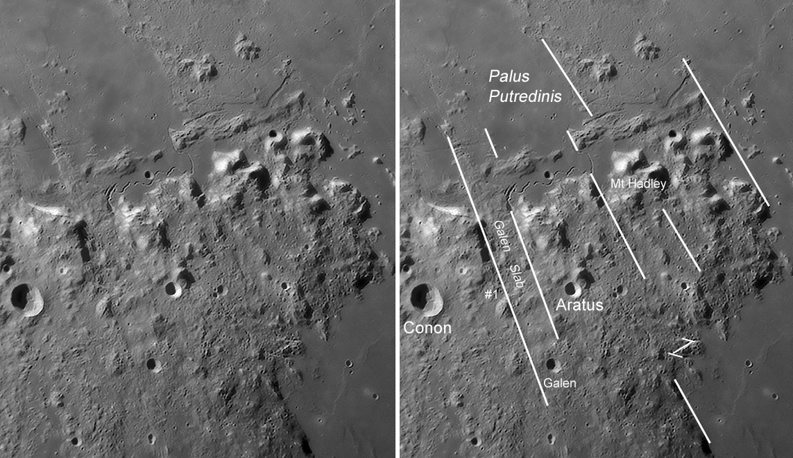
image by Bob Pilz, north mostly to the right.
Its called the Apennine Front after the idea of a continuous abrupt range of mountains, such as the Rocky Mountain Front. But Bob’s image makes it obvious that these lunar mountains aren’t continuous. This northern part of the Apennines is more broken than the main mass of the range to the southwest. And its cut up into long slabs of material with, at least in some places, straight borders. In particular, a long straight boundary (#1) slices northwestward from near Galen up past the edge of an unnamed curved bright mountain and becomes the edge of a swath of low hills southwest of Palus Putredinis. This Galen slab appears to be a place where a 25 km width of Apennines slid toward Imbrium; perhaps the finger of low hills that juts into Palus Putredinis (which erupted long after the material moved) is the jumbled up bits of this missing piece of the Apennine Front. Notice that material inside the Galen slab is smoother than material outside it. Perhaps that is due to the colossal joustling that must have happened as the slab slipped. And finally, note that the elongated crater at the head of the Hadley Rille occurs at the intersection of the probable fault that defines the northern edge of the slab and the Apennine Front! Hadley Rille probably exists because this intersection of faults provided a conduit to the surface for magma that formed at depth. The rille may be the source for the Palus Putredinis lavas.
Technical Details:
2007/08/04, Utime: ~07:45. 200mm f/6 Newtonian reflector, Televue 3x Barlow , DMK 21BF04 B/W camera, ‘Blue’ IR-block filter, Sampling = 1.9x (Airy disk FWHM at 510nm / 5.6 micron camera pixels) - 15 fps, 1/30 sec, 800/9000 frames stacked. Processed in Registax V4, PS CS, Focus Magic. Taken from Lat: 35 degrees 36 minutes N, Long: 82 degrees 33 minutes W, Elev: ~850m.
Related Links:
Rükl chart 22
Trace these Imbrium radial faults further north, and even more so!
Bob’s website
COMMENTS?
Click on this icon File:PostIcon.jpg at the upper right to post a comment.


