Difference between revisions of "January 19, 2012"
| Line 22: | Line 22: | ||
Rükl plate [http://the-moon.wikispaces.com/R%C3%BCkl+40 40]<br /> | Rükl plate [http://the-moon.wikispaces.com/R%C3%BCkl+40 40]<br /> | ||
<br /> | <br /> | ||
| + | <p><b>Yesterday's LPOD:</b> [[January 18, 2012|Outside]] </p> | ||
| + | <p><b>Tomorrow's LPOD:</b> [[January 20, 2012|Meow Rilles]] </p> | ||
<hr /> | <hr /> | ||
| − | |||
| − | |||
| − | |||
| − | |||
| − | |||
| − | |||
| − | |||
| − | |||
| − | |||
| − | |||
| − | |||
| − | |||
Revision as of 10:59, 7 February 2015
Northern Wow

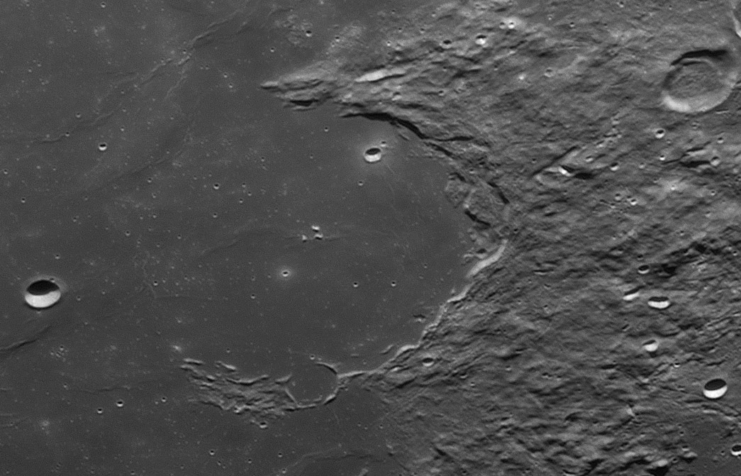
east up image by Michael Wirths, Baja California, Mexico
 |
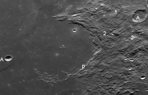
Moving north from his image of Gassendi, Mike captured an excellent view of Letronne, a 115 km wide half crater. Like many craters on the edges of maria it seems to have been tilted toward the mare, Oceanus Procellarum here, and its seaward wall cover by lavas. This happened a lot at nearby Humorum and the normal explanation is that the Humorum Basin center subsided due to the weight of the erupted lava. It is not clear if such subsidence occurred in this case because there may not have been a circular basin under Procellarum (other than the putative huge Procellarum Basin). Somehow Letronne lost its northern rim and was flooded with lavas so that only the tips of its summit mountains remain. The exterior of Letronne bears signs of a varied past. Its own ejecta and that from Gassendi probably overlap and is cut by flow features and narrow rilles. I also noticed two older flat-bottomed rilles that just barely survive. The first (labelled "1") extends northward from Gassendi A (top right) for about 40 km. The odd ridge inside "A" is not obviously associated with the rille. The second rille, above the number "2" is longer and better defined. The fact that it cuts the ejecta and extends nearly to Letronne's rim suggests that it is younger than that crater. But in some places ejecta (perhaps from Gassendi?) covers it. This may be a continuation of the Mersenius Rilles seen to the south. Continuing around the craters rim there is a peculiar pit or depression ("p") on the the mare. This could be the collapsed vent area for an old sinuous rille but there is no evidence for a rille. Finally the crater Flamsteed A (middle left) has an elevated rim on the east side that is unusual. Was "A" formed on a lower lava surface, and later a younger flow buried its ejecta except for that right around its rim? High Sun views show that the crater interior is very bright, but there is no bright nimbus around it. |
Technical Details
2012/01/05 18:28 UTC. 18" Starmaster dob (Zambuto optics) a Lumenera Infinity 2-2 camera, 4X's televue Powermate barlow, an R/IR filter. Processed with AviStack and PS CS.
Related Links
Rükl plate 40
Yesterday's LPOD: Outside
Tomorrow's LPOD: Meow Rilles


