Difference between revisions of "May 28, 2005"
| Line 53: | Line 53: | ||
</table> | </table> | ||
<p> </p> | <p> </p> | ||
| − | + | {{wiki/ArticleFooter}} | |
| − | |||
| − | |||
| − | |||
| − | |||
| − | |||
| − | |||
| − | |||
| − | |||
| − | |||
| − | |||
| − | |||
Revision as of 18:23, 1 February 2015
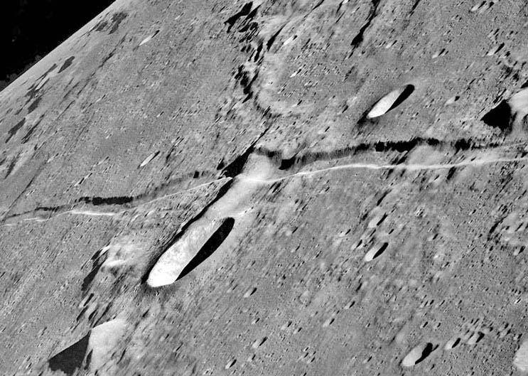
Down the Rille
Image Credit: Apollo 10 AS10-31-4646 |
|
Down the Rille Even when we have a great telescopic view of the Moon we typically see it as a distant world, without a sense of dimensionality. But the oblique Apollo images give us a feel for the real three-dimensional Moon. And the high resolution improves our understanding of the surface geology. This dramatic Apollo 10 view along the Ariadaeus Rille reveals it as a place rather than a line. Linear rilles such as the Ariadaeus are graben - places where the ground has slid down between two parallel bounding faults. We see that the sharp-edged walls slope inward - they are not vertical. The Ariadaeus Rille is wider where it cuts the ridge near the Silberschlag crater at the center of this image. This extra width compared to the lower areas allows the slope (or dip in geological terms) of the rille wall to be estimated as about 55 degrees. If this is correct, rilles have some on the steepest slopes on the Moon. Many linear rilles have associated volcanics and are probably formed over dikes. A dike is a narrow vertical sheet of magma that rises buoyantly towards the surface. The dike forces apart the lunar crust thus making the extensional forces that causes the parallel faults. Projecting the 55 degree slopes downward suggests that the base of the Ariadaeus graben faults is at depths of 2 to 3 km. This is the same as the average thickness of the megaregolith (the fragmental layer formed of ejecta from craters and basins), suggesting that the discontinuity in rock strength (strong below and weak above the megaregolith) gives rise to the dikes. Technical Details: Related Links: Yesterday's LPOD: Is It Love or a Sinus Infection? Tomorrow's LPOD: A Shallow Sea of Lava |
|
Author & Editor: Technical Consultant: Contact Translator: A service of: |
COMMENTS?
Register, Log in, and join in the comments.


