Difference between revisions of "July 29, 2012"
| Line 26: | Line 26: | ||
<br /> | <br /> | ||
<hr /> | <hr /> | ||
| + | <!-- Removed reference to store page --> | ||
| + | </div> | ||
| + | ---- | ||
| + | ===COMMENTS?=== | ||
| + | Register, and click on the <b>Discussion</b> tab at the top of the page. | ||
| + | <hr> | ||
| + | You can support LPOD when you buy any book from Amazon thru [[Support_ LPOD|LPOD]]! | ||
| + | <span style="font-size:88%"> | ||
| + | <center> | ||
| + | Contributions to http://www2.lpod.org/ are licensed under a Creative Commons Attribution No-Derivative-Works Non-Commercial 3.0 License. [http://www.creativecommons.org/licenses/by-nc-nd/3.0 http://www.wikispaces.com/i/creativecommons/by-nc-nd_3.0_80x15.png]<br> | ||
| + | </center> | ||
| + | </span> | ||
Revision as of 19:11, 31 January 2015
A Steep Part To Climb

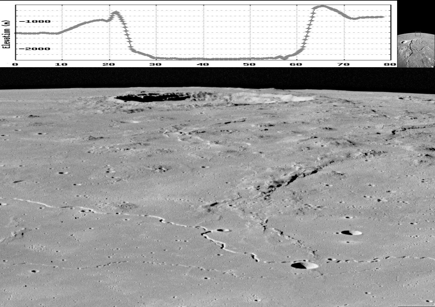
Apollo image AP15-M2611 from ASU Apollo Browse Gallery with 6 X vertical exaggeration cross-section from ASU's
QuickMap Path tool
The LRO QuickMap altimetry tool provides quantitative data on topography, and looking at oblique images gives a feel for it.
This image is a small piece near the limb of an Apollo Metric Camera photograph taken when the Apollo 15 Command Module
was over the Aristarchus Plateau. The small image at upper right shows the perspective, looking across the northeast corner
of the Marius Hills to Marius itself. The most interesting features of the foreground are two sinuous rilles that differ in width, depth
and degree of sinuosity. The more conspicuous is the Marius Rille and the smaller one is less well known, but its tight curves
bring to mind a description of a tightly meandering river on Earth: A river that doesn't know what to do with itself. My real interest
is in the profiles of Marius. Looking at both the Apollo image and the topo cross-section we can see two parts of the rim deposits.
On the left is a gentle rise in elevation of 500 m over a horizontal distance of about 10 km. And then right near the rim the slope
changes abruptly, with a rise of ~200 m in less than 2 km. The rim on the right (west) side has only the gently sloping fallback
deposits. I don't know what formed the steep segment of the rim. Rim elevations have two components - fallback and uplift due
to a sort of rebounding of the remaining country rocks when the material they were continuous with was instantly excavated and
removed. Is this narrow, steep section the rebound component? Finally, we should look carefully along the limbs of all obliques
Apollo images (and Kaguya's, too) for more profile views of craters and mountains.
Chuck Wood
Related Links
Rükl plate 18
COMMENTS?
Register, and click on the Discussion tab at the top of the page.
You can support LPOD when you buy any book from Amazon thru LPOD!
Contributions to http://www2.lpod.org/ are licensed under a Creative Commons Attribution No-Derivative-Works Non-Commercial 3.0 License. 


