Difference between revisions of "March 31, 2004"
| Line 72: | Line 72: | ||
---- | ---- | ||
===COMMENTS?=== | ===COMMENTS?=== | ||
| − | + | Register, and click on the <b>Discussion</b> tab at the top of the page. | |
Revision as of 15:19, 11 January 2015
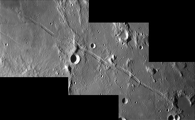
Great Graben!
Image Credit: Frederic Mallmann |
|
Great Graben! A graben is a linear block of land that has subsided between two parallel faults. On the Moon, such graben are usually called rilles - not the ["../02/LPOD-2004-02-29.htm" sinuous] kind (which are lava channels), but the straight or arcuate ones. The graben best placed for easy study is the Ariadaeus Rille, just east of the Moon's center of face. This remarkable image taken with the Ludiver 24" telescope shows great details of the rilles and its surroundings. The area west of here was shown on the Feb 25 ["../02/LPOD-2004-02-25.htm" LPOD]. The Ariadaeus graben is about 220 km long, 4.5 km wide and about 500 m deep. Presumably, it formed about 3.6 billion years ago, as did most lunar graben. Lunar graben have two origins - arcuate ones, such as those east of ["../01/LPOD-2004-01-26.htm" Humorum] form due to bending and fracturing of the lunar crust when basins centers, heavy with lava, subside. Linear graben form due to the extension exerted by intrusion of linear dikes. As a dike rises it wedges the near surface rocks apart, creating space for the graben to drop into. Sometimes the dike reaches the surface producing small cones and ash deposits. For Ariadaeus, the main evidence of nearby volcanism is a steep-sided, crater-topped dome near the rille's east end. Possible dark halo craters near the west end may not be volcanic features but small impacts that excavated dark mare material. Near the center of the Ariadaeus Rille is an offset which could be caused by a fault that shifted the east end of the rille northwards. However, the surrounding terrain shows no sign of movement, so an alternative explanation is that the dike simply died out, but a nearby parallel one continued in the same direction. This is frequently observed in terrestrial dike swarms. Finally, note the differences in the junction of subsidiary rilles at each end of the main rille. At the east end, the floors of the two rille segments appear to be level. At the west end, the main rille is younger than the other rille and cuts it off. Move your mouse over the image above to see an annotated one. Technical Details: Related Links: Tomorrow's LPOD: What Part of the Moon is This? |
|
Author & Editor: Technical Consultant: A service of: |
COMMENTS?
Register, and click on the Discussion tab at the top of the page.


