Difference between revisions of "May 6, 2011"
| Line 1: | Line 1: | ||
__NOTOC__ | __NOTOC__ | ||
=Beyond Frigoris= | =Beyond Frigoris= | ||
| − | |||
<!-- ws:start:WikiTextHeadingRule:0:<h1> --> | <!-- ws:start:WikiTextHeadingRule:0:<h1> --> | ||
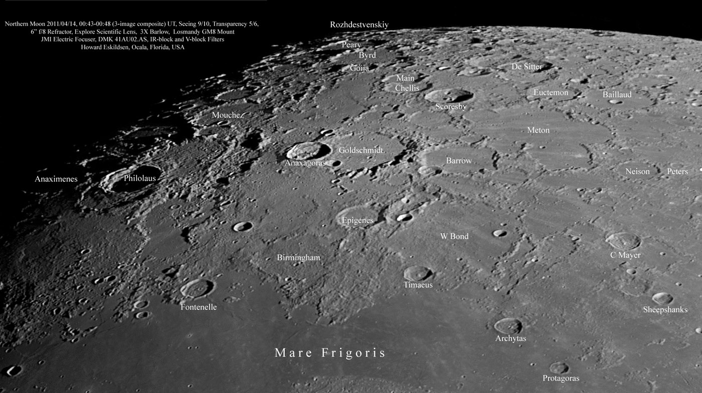
<!-- ws:start:WikiTextLocalImageRule:6:<img src="/file/view/LPOD-May6-11.jpg/226022126/LPOD-May6-11.jpg" alt="" title="" /> -->[[File:LPOD-May6-11.jpg|LPOD-May6-11.jpg]]<!-- ws:end:WikiTextLocalImageRule:6 --><br /> | <!-- ws:start:WikiTextLocalImageRule:6:<img src="/file/view/LPOD-May6-11.jpg/226022126/LPOD-May6-11.jpg" alt="" title="" /> -->[[File:LPOD-May6-11.jpg|LPOD-May6-11.jpg]]<!-- ws:end:WikiTextLocalImageRule:6 --><br /> | ||
| − | <em>image by [mailto:howardeskildsen@msn.com Howard Eskildsen]</em><br /> | + | <em>image by [mailto:howardeskildsen@msn.com" rel="nofollow Howard Eskildsen]</em><br /> |
<br /> | <br /> | ||
Do you not get lost but can't always remember the names of features near the north pole? <br /> | Do you not get lost but can't always remember the names of features near the north pole? <br /> | ||
| Line 17: | Line 16: | ||
destroyed the common walls but not the perimeter ones?<br /> | destroyed the common walls but not the perimeter ones?<br /> | ||
<br /> | <br /> | ||
| − | <em>[mailto:tychocrater@yahoo.com Chuck Wood]</em><br /> | + | <em>[mailto:tychocrater@yahoo.com" rel="nofollow Chuck Wood]</em><br /> |
<br /> | <br /> | ||
<strong>Related Links</strong><br /> | <strong>Related Links</strong><br /> | ||
Revision as of 21:15, 4 January 2015
Beyond Frigoris

image by " rel="nofollow Howard Eskildsen
Do you not get lost but can't always remember the names of features near the north pole?
If so, this LPOD will be a convenient image map to keep handy. The freshest distinctive
crater in this area is Anaxagoras, bright with rays once away from the terminator. Howard's
image nicely shows the broad swath of terrain where all the craters have shallow and
rather flat floors. The boundary to the west seems quite sharp, running from Byrd to Birm-
ingham, but the east edge is more jagged running roughly from Baillaund to W. Bond. This
is an area where ejecta from the formation of the Imbrium Basin filled in existing craters.
Meton is an interesting example, for apparently it was originally three or four separate craters
whose common walls were destroyed, creating a large and irregularly walled plain. What
destroyed the common walls but not the perimeter ones?
" rel="nofollow Chuck Wood
Related Links
Rükl plate 4


