Difference between revisions of "October 21, 2009"
| Line 1: | Line 1: | ||
__NOTOC__ | __NOTOC__ | ||
=Not the Moon= | =Not the Moon= | ||
| − | |||
<!-- ws:start:WikiTextHeadingRule:0:<h1> --> | <!-- ws:start:WikiTextHeadingRule:0:<h1> --> | ||
<!-- ws:start:WikiTextLocalImageRule:6:<img src="/file/view/LPOD-Oct21-09.jpg/96563938/LPOD-Oct21-09.jpg" alt="" title="" /> -->[[File:LPOD-Oct21-09.jpg|LPOD-Oct21-09.jpg]]<!-- ws:end:WikiTextLocalImageRule:6 --><br /> | <!-- ws:start:WikiTextLocalImageRule:6:<img src="/file/view/LPOD-Oct21-09.jpg/96563938/LPOD-Oct21-09.jpg" alt="" title="" /> -->[[File:LPOD-Oct21-09.jpg|LPOD-Oct21-09.jpg]]<!-- ws:end:WikiTextLocalImageRule:6 --><br /> | ||
| − | <em>image from [http://earthobservatory.nasa.gov/IOTD/view.php?id=40806&src=eoa-iotd NASA Earth Observatory]</em><br /> | + | <em>image from [http://earthobservatory.nasa.gov/IOTD/view.php?id=40806&src=eoa-iotd" rel="nofollow NASA Earth Observatory]</em><br /> |
<br /> | <br /> | ||
| − | Back in the late 1990s I directed <em>[http://volcano.oregonstate.edu/ VolcanoWorld]</em>, a NASA-funded website about volcanoes on Earth, and a little about those on other [http://volcano.oregonstate.edu/volcanoes/planet_volcano/index.html planets and moons]. Within three years VW was pulling in 4 million visitors/yr and was one of the largest science sites on the web (by comparison LPOD attracts about 1/10 that number, but has no funding nor staff). When I saw this image last night I knew it was too glorious to not use for LPOD. Marion Island is about 19 km wide and 1200 m above sea level, but the volcano rises 5 km above its base on the Southern Indian Ocean sea floor. The entire mountain is a basaltic shield volcano - like those of the Hawaiian Islands - and explosions creating the ruddy-hued cinder cones may have been powered by the interaction of rising magma with seawater. The Moon has a number of shield volcanoes - the domes - but they typically have lower slopes than terrestrial shields. The Moon typically doesn't have cinder cones (volcanic dark halo craters like those in Alphonsus and Atlas are gravity-modified equivalents), but the [http://lpod.wikispaces.com/November+24%2C+2008 Marius Hills] have three times as many cones as Marion Island. If you check the full res [http://earthobservatory.nasa.gov/images/imagerecords/40000/40806/princeedwardis_ali_2009125_lrg.jpg version] of the image you see a few lava channels, what we call sinuous rilles on the Moon.<br /> | + | Back in the late 1990s I directed <em>[http://volcano.oregonstate.edu/" rel="nofollow VolcanoWorld]</em>, a NASA-funded website about volcanoes on Earth, and a little about those on other [http://volcano.oregonstate.edu/volcanoes/planet_volcano/index.html" rel="nofollow planets and moons]. Within three years VW was pulling in 4 million visitors/yr and was one of the largest science sites on the web (by comparison LPOD attracts about 1/10 that number, but has no funding nor staff). When I saw this image last night I knew it was too glorious to not use for LPOD. Marion Island is about 19 km wide and 1200 m above sea level, but the volcano rises 5 km above its base on the Southern Indian Ocean sea floor. The entire mountain is a basaltic shield volcano - like those of the Hawaiian Islands - and explosions creating the ruddy-hued cinder cones may have been powered by the interaction of rising magma with seawater. The Moon has a number of shield volcanoes - the domes - but they typically have lower slopes than terrestrial shields. The Moon typically doesn't have cinder cones (volcanic dark halo craters like those in Alphonsus and Atlas are gravity-modified equivalents), but the [http://lpod.wikispaces.com/November+24%2C+2008 Marius Hills] have three times as many cones as Marion Island. If you check the full res [http://earthobservatory.nasa.gov/images/imagerecords/40000/40806/princeedwardis_ali_2009125_lrg.jpg" rel="nofollow version] of the image you see a few lava channels, what we call sinuous rilles on the Moon.<br /> |
<br /> | <br /> | ||
| − | <em>[mailto:tychocrater@yahoo.com Chuck Wood]</em><br /> | + | <em>[mailto:tychocrater@yahoo.com" rel="nofollow Chuck Wood]</em><br /> |
<br /> | <br /> | ||
<strong>Technical Details</strong><br /> | <strong>Technical Details</strong><br /> | ||
| Line 14: | Line 13: | ||
<br /> | <br /> | ||
<strong>Related Links</strong><br /> | <strong>Related Links</strong><br /> | ||
| − | Check this wide angle [http://earthobservatory.nasa.gov/images/imagerecords/40000/40806/princeedwardis_ali_2009125_lrg.jpg view] showing amazing cloud free zones as the topographic highs of Marion Island and Prince Edward Island block the clouds.<br /> | + | Check this wide angle [http://earthobservatory.nasa.gov/images/imagerecords/40000/40806/princeedwardis_ali_2009125_lrg.jpg" rel="nofollow view] showing amazing cloud free zones as the topographic highs of Marion Island and Prince Edward Island block the clouds.<br /> |
<br /> | <br /> | ||
<hr /> | <hr /> | ||
Revision as of 18:14, 4 January 2015
Not the Moon

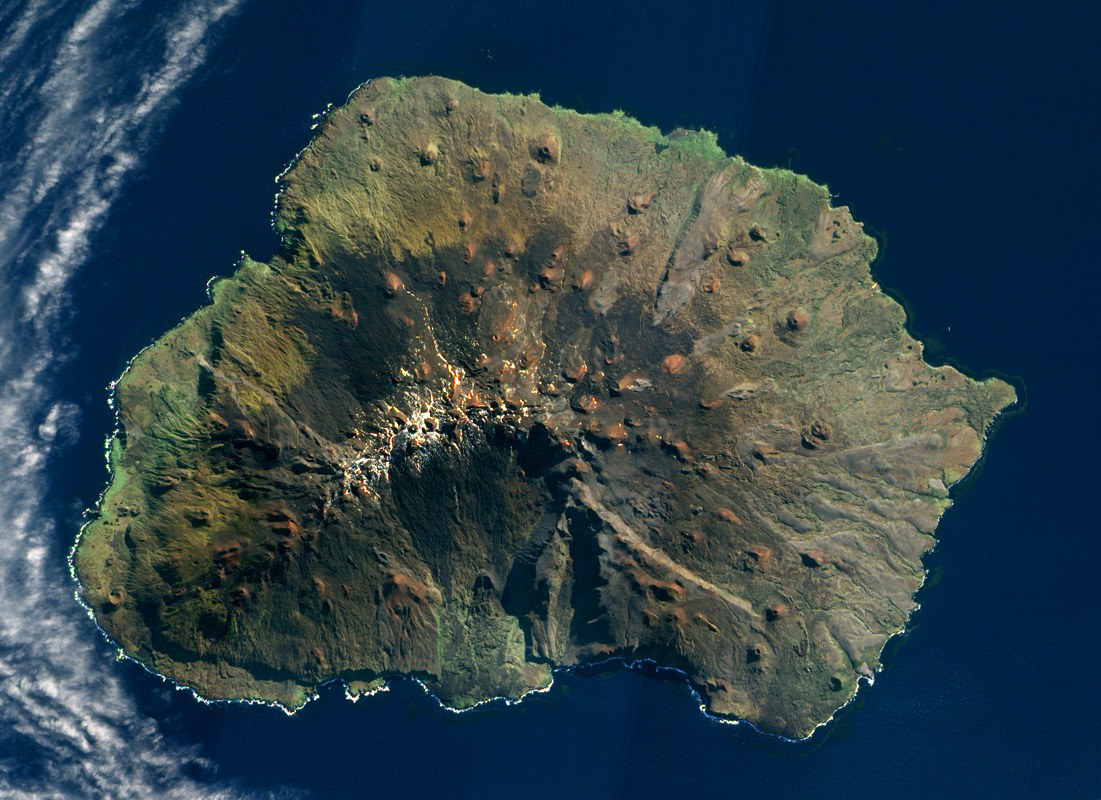
image from " rel="nofollow NASA Earth Observatory
Back in the late 1990s I directed " rel="nofollow VolcanoWorld, a NASA-funded website about volcanoes on Earth, and a little about those on other " rel="nofollow planets and moons. Within three years VW was pulling in 4 million visitors/yr and was one of the largest science sites on the web (by comparison LPOD attracts about 1/10 that number, but has no funding nor staff). When I saw this image last night I knew it was too glorious to not use for LPOD. Marion Island is about 19 km wide and 1200 m above sea level, but the volcano rises 5 km above its base on the Southern Indian Ocean sea floor. The entire mountain is a basaltic shield volcano - like those of the Hawaiian Islands - and explosions creating the ruddy-hued cinder cones may have been powered by the interaction of rising magma with seawater. The Moon has a number of shield volcanoes - the domes - but they typically have lower slopes than terrestrial shields. The Moon typically doesn't have cinder cones (volcanic dark halo craters like those in Alphonsus and Atlas are gravity-modified equivalents), but the Marius Hills have three times as many cones as Marion Island. If you check the full res " rel="nofollow version of the image you see a few lava channels, what we call sinuous rilles on the Moon.
" rel="nofollow Chuck Wood
Technical Details
May 5, 2009. EO-1 satellite, Advanced Land Imager (ALI).
Related Links
Check this wide angle " rel="nofollow view showing amazing cloud free zones as the topographic highs of Marion Island and Prince Edward Island block the clouds.


