Difference between revisions of "October 22, 2006"

From LPOD
Jump to: navigation, search
(Created page with "__NOTOC__ =Rings Around a Piddle= <div class="post" id="post-659"> <div class="storycontent"> <p>File:LPODCyrillusRabbiLeviMosaic071506.jpg|LPODCyrillusRabbiLeviMos...")
 
Line 1: Line 1:
 
__NOTOC__
 
__NOTOC__
 
=Rings Around a Piddle=
 
=Rings Around a Piddle=
 +
<div class="post" id="post-659">
  
+
<div class="storycontent">
<div class="post" id="post-659">
+
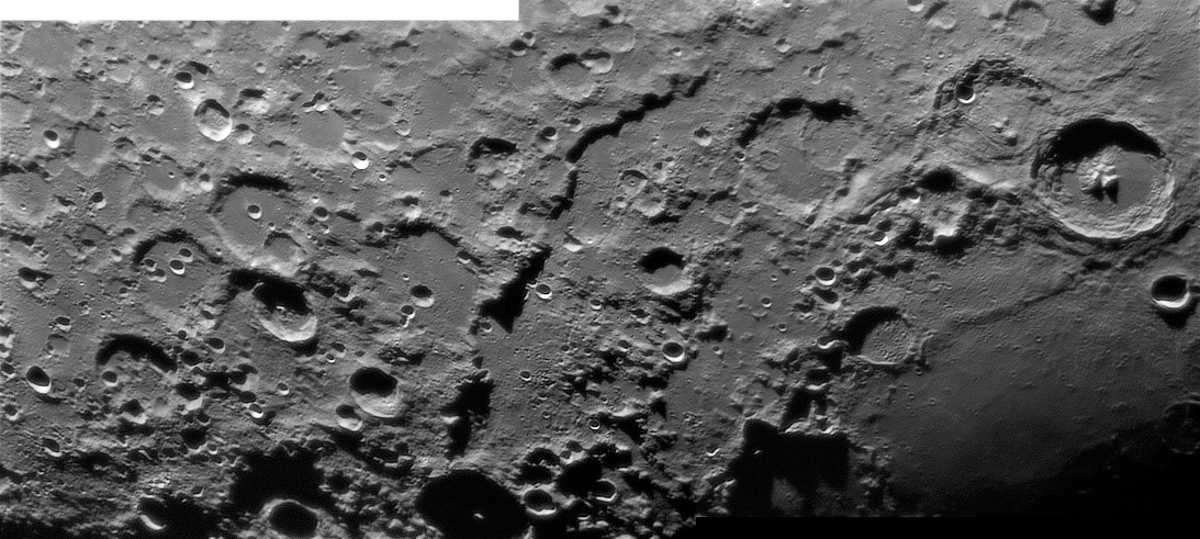
<p>[[File:LPODCyrillusRabbiLeviMosaic071506.jpg|LPODCyrillusRabbiLeviMosaic071506.jpg]]<br />
 
<div class="storycontent">
 
<p>[[File:LPODCyrillusRabbiLeviMosaic071506.jpg|LPODCyrillusRabbiLeviMosaic071506.jpg]]<br />
 
 
<em>image by [mailto:bob_p@earthlink.net Bob Pilz], north to the right</em></p>
 
<em>image by [mailto:bob_p@earthlink.net Bob Pilz], north to the right</em></p>
 
<p>The Altai Scarp is the Apennines of the Nectaris Basin. That means that the Altai is the main basin rim, but unlike the Imbrium rim it does not gradually decline in elevation away from the basin. An old topo [http://www.lpi.usra.edu/resources/mapcatalog/LAC/lac96/ map] shows that there is a slight lip. The quarter circle of the Altai Mountains defines an impact basin 860 km in diameter, and three other rings interior to this one are mapped. A battered 400 km wide Pyrenees ring (named because those hills define it to the east) passes from Fracastorius to Beaumont to Cyrillus. This ring is the boundary for most of the Nectaris lavas and for the positive gravity anomaly or mascon within the basin. A lot of impact craters pepper this ring, suggesting that it is older than the material to the east (of course, the mare is younger) and west (hmm). Between the Altai and Pyrenees rings is a broad, flattish elevated area that marks a 620 km ring that is cut by Catharina and Santbech. The broadness of this ring is reminiscent of inner Rook ring of the Orientale basin on the western limb. A partial inner ring, suggested by mare ridges such as the one from Theophilus to Beaumont, is about 240 km in diameter. The moat areas between the Altai and Catharina-Santbech rings, and the Catharina-Santbeck and the Pyrenees rings are lower, smoother and less heavily cratered. They are younger than the basin rings and probably are volcanics erupted onto the inter-ring depressions that have been lightened by rays and other crater ejecta. Supporting evidence for this interpretation is the occurrence of one of the Moon&#8217;s few non-mare (supposedly) domes northwest of Piccolomini - do you see it?</p>
 
<p>The Altai Scarp is the Apennines of the Nectaris Basin. That means that the Altai is the main basin rim, but unlike the Imbrium rim it does not gradually decline in elevation away from the basin. An old topo [http://www.lpi.usra.edu/resources/mapcatalog/LAC/lac96/ map] shows that there is a slight lip. The quarter circle of the Altai Mountains defines an impact basin 860 km in diameter, and three other rings interior to this one are mapped. A battered 400 km wide Pyrenees ring (named because those hills define it to the east) passes from Fracastorius to Beaumont to Cyrillus. This ring is the boundary for most of the Nectaris lavas and for the positive gravity anomaly or mascon within the basin. A lot of impact craters pepper this ring, suggesting that it is older than the material to the east (of course, the mare is younger) and west (hmm). Between the Altai and Pyrenees rings is a broad, flattish elevated area that marks a 620 km ring that is cut by Catharina and Santbech. The broadness of this ring is reminiscent of inner Rook ring of the Orientale basin on the western limb. A partial inner ring, suggested by mare ridges such as the one from Theophilus to Beaumont, is about 240 km in diameter. The moat areas between the Altai and Catharina-Santbech rings, and the Catharina-Santbeck and the Pyrenees rings are lower, smoother and less heavily cratered. They are younger than the basin rings and probably are volcanics erupted onto the inter-ring depressions that have been lightened by rays and other crater ejecta. Supporting evidence for this interpretation is the occurrence of one of the Moon&#8217;s few non-mare (supposedly) domes northwest of Piccolomini - do you see it?</p>
Line 17: Line 15:
 
[http://www.pbase.com/bob_p/image/ Bob&#8217;s website]<br />
 
[http://www.pbase.com/bob_p/image/ Bob&#8217;s website]<br />
 
[http://www.lpod.org/?m=20060517 A sunrise view]</p>
 
[http://www.lpod.org/?m=20060517 A sunrise view]</p>
</div>
+
</div>


----
 
----
 
===COMMENTS?===  
 
===COMMENTS?===  
 
Click on this icon [[image:PostIcon.jpg]] at the upper right to post a comment.
 
Click on this icon [[image:PostIcon.jpg]] at the upper right to post a comment.

Revision as of 17:44, 4 January 2015

Rings Around a Piddle

LPODCyrillusRabbiLeviMosaic071506.jpg
image by Bob Pilz, north to the right

The Altai Scarp is the Apennines of the Nectaris Basin. That means that the Altai is the main basin rim, but unlike the Imbrium rim it does not gradually decline in elevation away from the basin. An old topo map shows that there is a slight lip. The quarter circle of the Altai Mountains defines an impact basin 860 km in diameter, and three other rings interior to this one are mapped. A battered 400 km wide Pyrenees ring (named because those hills define it to the east) passes from Fracastorius to Beaumont to Cyrillus. This ring is the boundary for most of the Nectaris lavas and for the positive gravity anomaly or mascon within the basin. A lot of impact craters pepper this ring, suggesting that it is older than the material to the east (of course, the mare is younger) and west (hmm). Between the Altai and Pyrenees rings is a broad, flattish elevated area that marks a 620 km ring that is cut by Catharina and Santbech. The broadness of this ring is reminiscent of inner Rook ring of the Orientale basin on the western limb. A partial inner ring, suggested by mare ridges such as the one from Theophilus to Beaumont, is about 240 km in diameter. The moat areas between the Altai and Catharina-Santbech rings, and the Catharina-Santbeck and the Pyrenees rings are lower, smoother and less heavily cratered. They are younger than the basin rings and probably are volcanics erupted onto the inter-ring depressions that have been lightened by rays and other crater ejecta. Supporting evidence for this interpretation is the occurrence of one of the Moon’s few non-mare (supposedly) domes northwest of Piccolomini - do you see it?

Chuck Wood

Technical Details:
July 15, 2006, ~07:48 - 08:01UT. 150mm f/5 Newtonian reflector + Televue 3x Barlow + DMK 21BF04 B/W camera + ‘Blue’ IR-block filter; 15 fps, 1/27 sec, 600/6000 frames stacked. Processed in Registax, ImagesPlus, PS CS.

Related Links:
Rükl chart 57
Paul Spudis (1993) The Geology of Multi-Ring Impact Basins. Cambridge University Press.
Bob’s website
A sunrise view


COMMENTS?

Click on this icon File:PostIcon.jpg at the upper right to post a comment.