Difference between revisions of "March 25, 2012"
| Line 2: | Line 2: | ||
=Nw Imbrium Tour= | =Nw Imbrium Tour= | ||
| − | + | <!-- ws:start:WikiTextHeadingRule:0:<h1> --> | |
| − | |||
<table class="wiki_table"> | <table class="wiki_table"> | ||
| − | + | <tr> | |
| − | + | <td><!-- ws:start:WikiTextLocalImageRule:14:<img src="http://lpod.wikispaces.com/file/view/LPOD-Mar25-12.jpg/314268646/LPOD-Mar25-12.jpg" alt="" title="" /> -->[[File:LPOD-Mar25-12.jpg|LPOD-Mar25-12.jpg]]<!-- ws:end:WikiTextLocalImageRule:14 --><br /> | |
<em>image by [mailto:jocelyn.serot@wanadoo.fr Jocelyn Sérot], France</em><br /> | <em>image by [mailto:jocelyn.serot@wanadoo.fr Jocelyn Sérot], France</em><br /> | ||
</td> | </td> | ||
| − | + | <td><!-- ws:start:WikiTextLocalImageRule:15:<img src="http://lpod.wikispaces.com/file/view/LPOD-Mar25b-12.jpg/314268742/LPOD-Mar25b-12.jpg" alt="" title="" /> -->[[File:LPOD-Mar25b-12.jpg|LPOD-Mar25b-12.jpg]]<!-- ws:end:WikiTextLocalImageRule:15 --><br /> | |
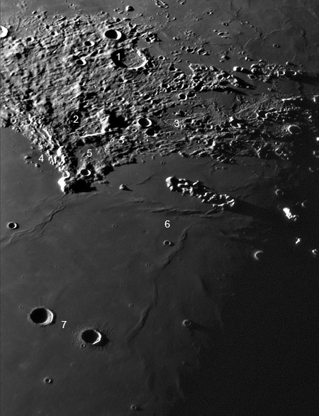
Images of compact regions - an eyepiece full at moderate to high power - often reveal numerous related landforms. See if you can determine the process that ties all of these - except for one - together. Item 1 is the 37 km wide, 1.5 km deep La Condamine, one of the few floor-fractured craters associated - by proximity - with Mare Frigoris. Telescopic views hint at the inner ring of mountains, and LRO orbital images reveal a nearly complete circle of rilles and fractures that cut the mountains. Maupertius (#2) has been strongly modified by ejecta from the Sinus Iridum crater and perhaps from Imbrium. Its western rim was overrun by ejecta, which also appears as ridges across its shallowed floor. The nearby Maupertius Rille (#3) is one of 3-5 that cut the mountainous ejecta that extends from Plato westward. Using the LRO Path tool I measured the rille to be ~50 km long and to descend 400 m as it winds from north to south. The LRO Quick-Map also shows another similar rille just to the east but the two do not appear to join. This rille is 30 km long, dropping 500 m in elevation. A third nearby, 9 km long rille extends to the north, suggesting that this was a significant lava source area. <br /> | Images of compact regions - an eyepiece full at moderate to high power - often reveal numerous related landforms. See if you can determine the process that ties all of these - except for one - together. Item 1 is the 37 km wide, 1.5 km deep La Condamine, one of the few floor-fractured craters associated - by proximity - with Mare Frigoris. Telescopic views hint at the inner ring of mountains, and LRO orbital images reveal a nearly complete circle of rilles and fractures that cut the mountains. Maupertius (#2) has been strongly modified by ejecta from the Sinus Iridum crater and perhaps from Imbrium. Its western rim was overrun by ejecta, which also appears as ridges across its shallowed floor. The nearby Maupertius Rille (#3) is one of 3-5 that cut the mountainous ejecta that extends from Plato westward. Using the LRO Path tool I measured the rille to be ~50 km long and to descend 400 m as it winds from north to south. The LRO Quick-Map also shows another similar rille just to the east but the two do not appear to join. This rille is 30 km long, dropping 500 m in elevation. A third nearby, 9 km long rille extends to the north, suggesting that this was a significant lava source area. <br /> | ||
<br /> | <br /> | ||
At #4 there are two or three domes/swells that have been documented by the Geologic Lunar Research group. I note another domelike feature just above the number 5. It is not easy to measure but appears to be about 7 km wide and 300 m high. The #6 is placed near where two mare ridges converge and it is meant to remind that the tectonic reason that particular mare ridges formed is still often unknown. We do know that some mare ridges mark buried crater rims and basin inner rings, but these don't. To the west of the #6 is a small dimple that we have seen [http://lpod.wikispaces.com/January+27%2C+2011 before] - it may be a small impact crater just barely draped by lava flows. Finally #7 is between two similar sized craters. Le Verrier, on the right, has ejecta deposits on the Imbrium surface - it formed on top of the lavas. Helicon's ejecta is covered by lava flows so it formed on a previous surface of the mare. The LRO altimeter tool provides additional evidence of this. Le Verrier's rim rises 500 m above the mare surface, but Helicon's is only 280 m high; we can estimate that lavas risen 220 m above the level Helicon formed on.<br /> | At #4 there are two or three domes/swells that have been documented by the Geologic Lunar Research group. I note another domelike feature just above the number 5. It is not easy to measure but appears to be about 7 km wide and 300 m high. The #6 is placed near where two mare ridges converge and it is meant to remind that the tectonic reason that particular mare ridges formed is still often unknown. We do know that some mare ridges mark buried crater rims and basin inner rings, but these don't. To the west of the #6 is a small dimple that we have seen [http://lpod.wikispaces.com/January+27%2C+2011 before] - it may be a small impact crater just barely draped by lava flows. Finally #7 is between two similar sized craters. Le Verrier, on the right, has ejecta deposits on the Imbrium surface - it formed on top of the lavas. Helicon's ejecta is covered by lava flows so it formed on a previous surface of the mare. The LRO altimeter tool provides additional evidence of this. Le Verrier's rim rises 500 m above the mare surface, but Helicon's is only 280 m high; we can estimate that lavas risen 220 m above the level Helicon formed on.<br /> | ||
</td> | </td> | ||
| − | + | </tr> | |
</table> | </table> | ||
| − | |||
<br /> | <br /> | ||
<em>[mailto:tychocrater@yahoo.com Chuck Wood]</em><br /> | <em>[mailto:tychocrater@yahoo.com Chuck Wood]</em><br /> | ||
| Line 27: | Line 25: | ||
<br /> | <br /> | ||
<hr /> | <hr /> | ||
| − | |||
| − | |||
| − | |||
| − | |||
| − | |||
Revision as of 23:27, 2 January 2015
Nw Imbrium Tour
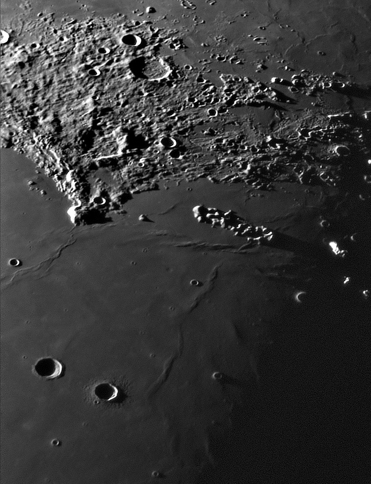
 image by Jocelyn Sérot, France |
 Images of compact regions - an eyepiece full at moderate to high power - often reveal numerous related landforms. See if you can determine the process that ties all of these - except for one - together. Item 1 is the 37 km wide, 1.5 km deep La Condamine, one of the few floor-fractured craters associated - by proximity - with Mare Frigoris. Telescopic views hint at the inner ring of mountains, and LRO orbital images reveal a nearly complete circle of rilles and fractures that cut the mountains. Maupertius (#2) has been strongly modified by ejecta from the Sinus Iridum crater and perhaps from Imbrium. Its western rim was overrun by ejecta, which also appears as ridges across its shallowed floor. The nearby Maupertius Rille (#3) is one of 3-5 that cut the mountainous ejecta that extends from Plato westward. Using the LRO Path tool I measured the rille to be ~50 km long and to descend 400 m as it winds from north to south. The LRO Quick-Map also shows another similar rille just to the east but the two do not appear to join. This rille is 30 km long, dropping 500 m in elevation. A third nearby, 9 km long rille extends to the north, suggesting that this was a significant lava source area. |
Chuck Wood
Technical Details
Sept 24, 2011, 4:35 UT. T200 Newton, Barlow 3x
Related Links
Rükl plate 11


