Difference between revisions of "March 29, 2010"
| Line 1: | Line 1: | ||
__NOTOC__ | __NOTOC__ | ||
=Lonely Mountains= | =Lonely Mountains= | ||
| − | |||
<!-- ws:start:WikiTextHeadingRule:1:<h1> --> | <!-- ws:start:WikiTextHeadingRule:1:<h1> --> | ||
<!-- ws:start:WikiTextLocalImageRule:16:<img src="/file/view/LPOD-Mar29-10.jpg/130947387/LPOD-Mar29-10.jpg" alt="" title="" /> -->[[File:LPOD-Mar29-10.jpg|LPOD-Mar29-10.jpg]]<!-- ws:end:WikiTextLocalImageRule:16 --><br /> | <!-- ws:start:WikiTextLocalImageRule:16:<img src="/file/view/LPOD-Mar29-10.jpg/130947387/LPOD-Mar29-10.jpg" alt="" title="" /> -->[[File:LPOD-Mar29-10.jpg|LPOD-Mar29-10.jpg]]<!-- ws:end:WikiTextLocalImageRule:16 --><br /> | ||
| − | <em>image by [mailto:paolo@lazzarotti-hires.com Paolo R. Lazzarotti], Massa, Italy</em><br /> | + | <em>image by [mailto:paolo@lazzarotti-hires.com" rel="nofollow Paolo R. Lazzarotti], Massa, Italy</em><br /> |
<br /> | <br /> | ||
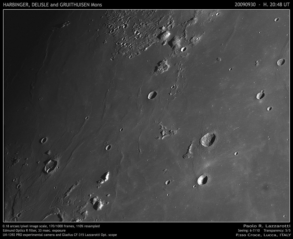
| − | Paolo calls this an area of lonely mountains, and his poetic term captures the essence of a mystery. Where is the western rim of the Imbrium impact basin? It is remarkably different from the east side, which is starkly defined by the towering [ | + | Paolo calls this an area of lonely mountains, and his poetic term captures the essence of a mystery. Where is the western rim of the Imbrium impact basin? It is remarkably different from the east side, which is starkly defined by the towering [/March+28%2C+2010 Apennine Mountains]. The Apennines are the rim of the giant basin, but the rim is drastically lower on the basin's south side (the Carpathian Mountains) and is mostly marked by ejecta on the north. But to the west the basin rim essentially doesn't exist. From this perspective the Inbrium Basin is like the Iridum crater, whose entire southern rim is missing. In the case of Iridum the crater formed on the edge of a deep basin and either its southern rim formed much lower and was covered by lavas, or it was faulted down and is covered by lavas. Did the same thing happen to Imbrium? The western curved edge of Oceanus Procellarum has been postulated to be the rim of an ancient Gargantuan or [http://the-moon.wikispaces.com/Procellarum+Basin Procellarum Basin], 3200 km in diameter. Many lunar scientists doubt the existence of this putative old basin, but even if it didn't exist the Procellarum area, before flooding by mare lavas, was low, so that perhaps the Imbrium rim on this side was also low. In this case the few lonely peaks such as [http://the-moon.wikispaces.com/Mons+Delisle Delisle Mountain] are abnormally high portions of Imbrium's western rim that poke up out of the thick pile of mare.<br /> |
<br /> | <br /> | ||
| − | <em>[mailto:tychocrater@yahoo.com Chuck Wood]</em><br /> | + | <em>[mailto:tychocrater@yahoo.com" rel="nofollow Chuck Wood]</em><br /> |
<br /> | <br /> | ||
<strong>Technical Details</strong><br /> | <strong>Technical Details</strong><br /> | ||
| Line 15: | Line 14: | ||
<strong>Related Links</strong><br /> | <strong>Related Links</strong><br /> | ||
Rükl plate [http://the-moon.wikispaces.com/R%C3%BCkl+19 19]<br /> | Rükl plate [http://the-moon.wikispaces.com/R%C3%BCkl+19 19]<br /> | ||
| − | Paolo's [http://www.lazzarotti-hires.com/2010/03/montagne-isolate.html website]<br /> | + | Paolo's [http://www.lazzarotti-hires.com/2010/03/montagne-isolate.html" rel="nofollow website]<br /> |
<br /> | <br /> | ||
<hr /> | <hr /> | ||
| − | <div>You can support LPOD when you buy any book from Amazon thru [http://www.lpod.org/?page_id=591 LPOD!]<br /> | + | <div>You can support LPOD when you buy any book from Amazon thru [http://www.lpod.org/?page_id=591" rel="nofollow LPOD!]<br /> |
</div> | </div> | ||
| − | |||
---- | ---- | ||
===COMMENTS?=== | ===COMMENTS?=== | ||
Click on this icon [[image:PostIcon.jpg]] at the upper right to post a comment. | Click on this icon [[image:PostIcon.jpg]] at the upper right to post a comment. | ||
Revision as of 18:21, 4 January 2015
Lonely Mountains

image by " rel="nofollow Paolo R. Lazzarotti, Massa, Italy
Paolo calls this an area of lonely mountains, and his poetic term captures the essence of a mystery. Where is the western rim of the Imbrium impact basin? It is remarkably different from the east side, which is starkly defined by the towering [/March+28%2C+2010 Apennine Mountains]. The Apennines are the rim of the giant basin, but the rim is drastically lower on the basin's south side (the Carpathian Mountains) and is mostly marked by ejecta on the north. But to the west the basin rim essentially doesn't exist. From this perspective the Inbrium Basin is like the Iridum crater, whose entire southern rim is missing. In the case of Iridum the crater formed on the edge of a deep basin and either its southern rim formed much lower and was covered by lavas, or it was faulted down and is covered by lavas. Did the same thing happen to Imbrium? The western curved edge of Oceanus Procellarum has been postulated to be the rim of an ancient Gargantuan or Procellarum Basin, 3200 km in diameter. Many lunar scientists doubt the existence of this putative old basin, but even if it didn't exist the Procellarum area, before flooding by mare lavas, was low, so that perhaps the Imbrium rim on this side was also low. In this case the few lonely peaks such as Delisle Mountain are abnormally high portions of Imbrium's western rim that poke up out of the thick pile of mare.
" rel="nofollow Chuck Wood
Technical Details
See top and bottom of image
Related Links
Rükl plate 19
Paolo's " rel="nofollow website
COMMENTS?
Click on this icon File:PostIcon.jpg at the upper right to post a comment.


