Difference between revisions of "August 18, 2006"

From LPOD
Jump to: navigation, search
(Created page with "__NOTOC__ =A Nearly New Rille= <div class="post" id="post-500"> <div class="storycontent"> <p>lambert-Wirths-LPOD.jpg<br /> <em>image...")
 
Line 1: Line 1:
 
__NOTOC__
 
__NOTOC__
 
=A Nearly New Rille=
 
=A Nearly New Rille=
 +
<div class="post" id="post-500">
  
+
<div class="storycontent">
<div class="post" id="post-500">
+
<p>[[File:Lambert-Wirths-LPOD.jpg|lambert-Wirths-LPOD.jpg]]<br />
 
<div class="storycontent">
 
<p>[[File:Lambert-Wirths-LPOD.jpg|lambert-Wirths-LPOD.jpg]]<br />
 
 
<em>image by [mailto:mwirths@superaje.com Mike Wirths]</em></p>
 
<em>image by [mailto:mwirths@superaje.com Mike Wirths]</em></p>
 
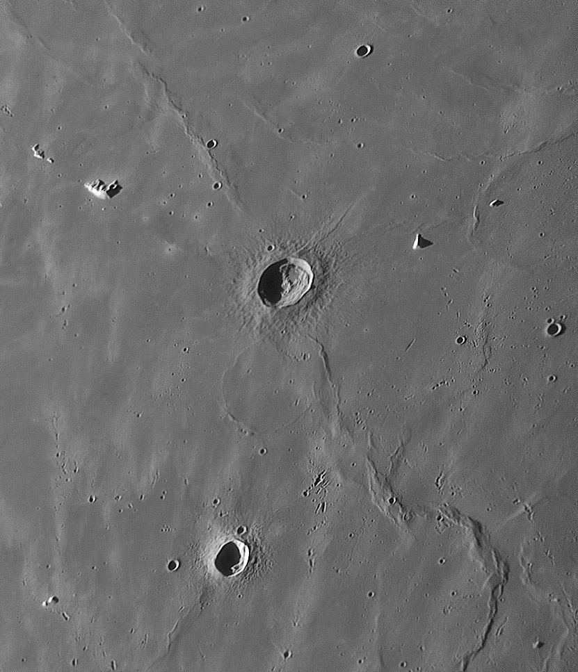
<p>When a magnificent image comes in to LPOD there are usually many well defined features to discuss. For example, Mike&#8217;s new image of the Lambert to [http://www.lpod.org/?m=20060302 Pytheas] area in southern Mare Imbrium shows those craters and their ejecta patterns superposed on the mare, and clusters of secondary craters at the heads of Copernicus rays. But I want to focus on the faint rille east of Pytheas. I didn&#8217;t know this rille existed; its not shown in Rükl&#8217;s <i>Atlas of the Moon</i>, but is visible on the Lunar Orbiter IV image, if you know the rille exists. It is well shown on the Apollo 17 Metric Camera [http://www.lpi.usra.edu/resources/apollo/frame/?AS17-M-2285 images,] but this may be the first time it has been imaged from Earth. This Pytheas I rille (I just named it) is a slightly sinuous rille starting in the south and winding northward until it hits the tip of a mare ridge. The Metric Camera view shows that the rille cuts through the ridge and continues northward another 20-30 km; the northward extension is also visible on Mike&#8217;s image. This faint rille and similar ones that show up where ever there are very high resolution mare images with low lighting illustrate how mare lavas were emplaced. Lava erupts onto the surface and flows rapidly downhill, zigging and zagging around small topographic obstacles. Levees form along the margins of the flow, constraining it within a channel that we call a rille. Probably rilles occurred widely across the mare but have been eroded by the steady rain of small random impacts, or in this area by the splat of secondary clusters.</p>
 
<p>When a magnificent image comes in to LPOD there are usually many well defined features to discuss. For example, Mike&#8217;s new image of the Lambert to [http://www.lpod.org/?m=20060302 Pytheas] area in southern Mare Imbrium shows those craters and their ejecta patterns superposed on the mare, and clusters of secondary craters at the heads of Copernicus rays. But I want to focus on the faint rille east of Pytheas. I didn&#8217;t know this rille existed; its not shown in Rükl&#8217;s <i>Atlas of the Moon</i>, but is visible on the Lunar Orbiter IV image, if you know the rille exists. It is well shown on the Apollo 17 Metric Camera [http://www.lpi.usra.edu/resources/apollo/frame/?AS17-M-2285 images,] but this may be the first time it has been imaged from Earth. This Pytheas I rille (I just named it) is a slightly sinuous rille starting in the south and winding northward until it hits the tip of a mare ridge. The Metric Camera view shows that the rille cuts through the ridge and continues northward another 20-30 km; the northward extension is also visible on Mike&#8217;s image. This faint rille and similar ones that show up where ever there are very high resolution mare images with low lighting illustrate how mare lavas were emplaced. Lava erupts onto the surface and flows rapidly downhill, zigging and zagging around small topographic obstacles. Levees form along the margins of the flow, constraining it within a channel that we call a rille. Probably rilles occurred widely across the mare but have been eroded by the steady rain of small random impacts, or in this area by the splat of secondary clusters.</p>
Line 16: Line 14:
 
[http://www.lpi.usra.edu/resources/lunar_orbiter/images/img/iv_121_h3.jpg Lunar Orbiter IV view]</p>
 
[http://www.lpi.usra.edu/resources/lunar_orbiter/images/img/iv_121_h3.jpg Lunar Orbiter IV view]</p>
 
<p align="center"><em>You can support LPOD when you buy ANY book from Amazon thru </em><em>[http://www.lpod.org/?page_id=102  LPOD!]</em></p>
 
<p align="center"><em>You can support LPOD when you buy ANY book from Amazon thru </em><em>[http://www.lpod.org/?page_id=102  LPOD!]</em></p>
</div>
+
</div>


----
 
----
 
===COMMENTS?===  
 
===COMMENTS?===  
 
Click on this icon [[image:PostIcon.jpg]] at the upper right to post a comment.
 
Click on this icon [[image:PostIcon.jpg]] at the upper right to post a comment.

Revision as of 17:41, 4 January 2015

A Nearly New Rille

lambert-Wirths-LPOD.jpg
image by Mike Wirths

When a magnificent image comes in to LPOD there are usually many well defined features to discuss. For example, Mike’s new image of the Lambert to Pytheas area in southern Mare Imbrium shows those craters and their ejecta patterns superposed on the mare, and clusters of secondary craters at the heads of Copernicus rays. But I want to focus on the faint rille east of Pytheas. I didn’t know this rille existed; its not shown in Rükl’s Atlas of the Moon, but is visible on the Lunar Orbiter IV image, if you know the rille exists. It is well shown on the Apollo 17 Metric Camera images, but this may be the first time it has been imaged from Earth. This Pytheas I rille (I just named it) is a slightly sinuous rille starting in the south and winding northward until it hits the tip of a mare ridge. The Metric Camera view shows that the rille cuts through the ridge and continues northward another 20-30 km; the northward extension is also visible on Mike’s image. This faint rille and similar ones that show up where ever there are very high resolution mare images with low lighting illustrate how mare lavas were emplaced. Lava erupts onto the surface and flows rapidly downhill, zigging and zagging around small topographic obstacles. Levees form along the margins of the flow, constraining it within a channel that we call a rille. Probably rilles occurred widely across the mare but have been eroded by the steady rain of small random impacts, or in this area by the splat of secondary clusters.

Chuck Wood

Technical Details:
17 August 2006. 18″ Starmaster + camera Lumenera Infinity 2-2 + 2.5X Powermate barlow + red filter; Registax 3 MAP processing (18 points). CAW stretched this beyond the tonal smoothness of Mike’s original to better show the rille.

Related Links:
Rükl charts 20
Lunar Orbiter IV view

You can support LPOD when you buy ANY book from Amazon thru LPOD!


COMMENTS?

Click on this icon File:PostIcon.jpg at the upper right to post a comment.