Difference between revisions of "July 4, 2008"
| Line 6: | Line 6: | ||
images from [http://www.lpi.usra.edu/meetings/nlsc2008/pdf/2060.pdf B.L. Cooper et al.] and [mailto:jeromegrenier@free.fr Jérôme Grenier] (center)<br /> | images from [http://www.lpi.usra.edu/meetings/nlsc2008/pdf/2060.pdf B.L. Cooper et al.] and [mailto:jeromegrenier@free.fr Jérôme Grenier] (center)<br /> | ||
<br /> | <br /> | ||
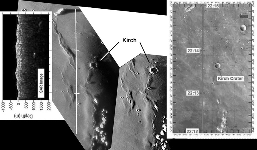
| − | The Kaguya spacecraft carries an array of powerful sensors that have the capability of transforming our knowledge of the Moon. One more snippet of data recently appeared in a contribution to the upcoming first NASA Lunar Science Institute [http://www.lpi.usra.edu/meetings/nlsc2008/ Lunar Science Conference] - that's a mouthful! B.L. Cooper and colleagues presented an [http://www.lpi.usra.edu/meetings/nlsc2008/pdf/2060.pdf analysis] of a couple hundred kilometer long strip of Lunar Radar Sounder (LRS) data for a piece of Mare Imbrium just west of the crater Kirch. LRS beams pulses of energy into the lunar surface, mapping out buried structures down as deep as a few kilometers. The strip analyzed (left) doesn't show anything very definitive. The composite image that I assembled above hints why. The published report included the radar cross-section (left image) and a Clementine image showing the ground track (right). I have inserted in the middle Jérôme Grenier's two low Sun images from a previous [ | + | The Kaguya spacecraft carries an array of powerful sensors that have the capability of transforming our knowledge of the Moon. One more snippet of data recently appeared in a contribution to the upcoming first NASA Lunar Science Institute [http://www.lpi.usra.edu/meetings/nlsc2008/ Lunar Science Conference] - that's a mouthful! B.L. Cooper and colleagues presented an [http://www.lpi.usra.edu/meetings/nlsc2008/pdf/2060.pdf analysis] of a couple hundred kilometer long strip of Lunar Radar Sounder (LRS) data for a piece of Mare Imbrium just west of the crater Kirch. LRS beams pulses of energy into the lunar surface, mapping out buried structures down as deep as a few kilometers. The strip analyzed (left) doesn't show anything very definitive. The composite image that I assembled above hints why. The published report included the radar cross-section (left image) and a Clementine image showing the ground track (right). I have inserted in the middle Jérôme Grenier's two low Sun images from a previous [[February_26,_2006|LPOD]]. By bad luck this particular LRS path just missed the mare ridges as well as Kirch. I don't know how broad the radar pulses are but they didn't seem to have interacted with the mare ridge just west of the upper tick mark (22:14). Sooner or later LRS will cross mare ridges and presumably show layers of lava that are off-set by the low angle faults - it will be very interesting to see how deep the faults go and how much off-set occurs. I hope Kaguya is successful at mapping the entire Moon with the radar sounder! And I hope the analyst teams consider the value of low-Sun amateur imaging in interpreting spacecraft data. <br /> |
<br /> | <br /> | ||
<em>[mailto:tychocrater@yahoo.com Chuck Wood]</em><br /> | <em>[mailto:tychocrater@yahoo.com Chuck Wood]</em><br /> | ||
Latest revision as of 21:19, 22 March 2015
X-Raying Imbrium

images from B.L. Cooper et al. and Jérôme Grenier (center)
The Kaguya spacecraft carries an array of powerful sensors that have the capability of transforming our knowledge of the Moon. One more snippet of data recently appeared in a contribution to the upcoming first NASA Lunar Science Institute Lunar Science Conference - that's a mouthful! B.L. Cooper and colleagues presented an analysis of a couple hundred kilometer long strip of Lunar Radar Sounder (LRS) data for a piece of Mare Imbrium just west of the crater Kirch. LRS beams pulses of energy into the lunar surface, mapping out buried structures down as deep as a few kilometers. The strip analyzed (left) doesn't show anything very definitive. The composite image that I assembled above hints why. The published report included the radar cross-section (left image) and a Clementine image showing the ground track (right). I have inserted in the middle Jérôme Grenier's two low Sun images from a previous LPOD. By bad luck this particular LRS path just missed the mare ridges as well as Kirch. I don't know how broad the radar pulses are but they didn't seem to have interacted with the mare ridge just west of the upper tick mark (22:14). Sooner or later LRS will cross mare ridges and presumably show layers of lava that are off-set by the low angle faults - it will be very interesting to see how deep the faults go and how much off-set occurs. I hope Kaguya is successful at mapping the entire Moon with the radar sounder! And I hope the analyst teams consider the value of low-Sun amateur imaging in interpreting spacecraft data.
Chuck Wood
Technical Details
The left image shows a cross-section of the surface topography and the bright zones are reflections from buried surfaces. The bright spot in the middle of the image at a depth of about 1 km could be the buried expression of the nearby mare ridge.
Related Links
Rükl chart 12
Jérôme’s Website
Yesterday's LPOD: Worlds in Evolution
Tomorrow's LPOD: Red, White & Blue Moon
COMMENTS?
Register, Log in, and join in the comments.


