Difference between revisions of "October 21, 2006"

From LPOD
Jump to: navigation, search
Line 8: Line 8:
 
<p>Tall peaks, named the Leibnitz Mountains by Schröter, are visible near the lunar south pole, but it was difficult for the International Astronomical Union nomenclature committee to identify them and the name was erased from modern maps. But the peaks are there and the largest ones were accurately depicted in a famous map by Ewen Whitaker in 1954. I decided to use the Clementine mosaic of the south polar region, along with terrestrial radar images of the pole to look for shadow-casting peaks that are not just crater rims. I was amazed to find that there are many isolated peaks, marked in red. The white letter M and number from 1 to 5 indicate my best guess of the peaks M1 to M5 labeled on Whitaker&#8217;s chart. Some of the peaks in this area are considered to be parts of the rim of the South Pole Aitken basin - the US [http://astrogeology.usgs.gov/Projects/PlanetaryMapping/DIGGEOL/moon/1162/lsmap.pdf Geological Survey] mapped a ring passing through Demonax, near Newton and near the south rim of Bailly. Some peaks shown here (90°E, 78°S, and 30°-45°W, 78°S) lie on that rim arc, but many more are interior to it, near where the rim is shown in another [http://www.cmf.nrl.navy.mil/clementine/water/moon_ice.JPG depiction]. It seems that a new study of these polar mountains using Clementine and radar images would shed light on the South Pole-Aitken basin.</p>
 
<p>Tall peaks, named the Leibnitz Mountains by Schröter, are visible near the lunar south pole, but it was difficult for the International Astronomical Union nomenclature committee to identify them and the name was erased from modern maps. But the peaks are there and the largest ones were accurately depicted in a famous map by Ewen Whitaker in 1954. I decided to use the Clementine mosaic of the south polar region, along with terrestrial radar images of the pole to look for shadow-casting peaks that are not just crater rims. I was amazed to find that there are many isolated peaks, marked in red. The white letter M and number from 1 to 5 indicate my best guess of the peaks M1 to M5 labeled on Whitaker&#8217;s chart. Some of the peaks in this area are considered to be parts of the rim of the South Pole Aitken basin - the US [http://astrogeology.usgs.gov/Projects/PlanetaryMapping/DIGGEOL/moon/1162/lsmap.pdf Geological Survey] mapped a ring passing through Demonax, near Newton and near the south rim of Bailly. Some peaks shown here (90°E, 78°S, and 30°-45°W, 78°S) lie on that rim arc, but many more are interior to it, near where the rim is shown in another [http://www.cmf.nrl.navy.mil/clementine/water/moon_ice.JPG depiction]. It seems that a new study of these polar mountains using Clementine and radar images would shed light on the South Pole-Aitken basin.</p>
 
<p align="right"><em>Chuck Wood</em></p>
 
<p align="right"><em>Chuck Wood</em></p>
<p><strong>Related Links:</strong><br />
 
Rükl plate 73<br />
 
[http://www.psrd.hawaii.edu/July98/spa.html South Pole-Aitkin basin]<br />
 
[[December_29,_2004|A terrestrial view]]<br />
 
<strong><br />
 
<em>Now you can support LPOD when you buy ANY book from Amazon thru [http://www.lpod.org/?page_id=102  LPOD!] More than a dozen books have been bought so far - Thanks!</em></strong></p>
 
 
<p><b>Yesterday's LPOD:</b> [[October 20, 2006|A Gash and a River]] </p>
 
<p><b>Yesterday's LPOD:</b> [[October 20, 2006|A Gash and a River]] </p>
 
<p><b>Tomorrow's LPOD:</b> [[October 22, 2006|Rings Around a Piddle]] </p>
 
<p><b>Tomorrow's LPOD:</b> [[October 22, 2006|Rings Around a Piddle]] </p>
 +
<p><strong>Related Links:</strong><br />
 +
<!-- Removed reference to store page -->
 
</div>
 
</div>
 
----
 
----

Revision as of 15:06, 1 February 2015

Mountains Near the South Pole

LPOD-S-Pole-Clem-Mts.jpg
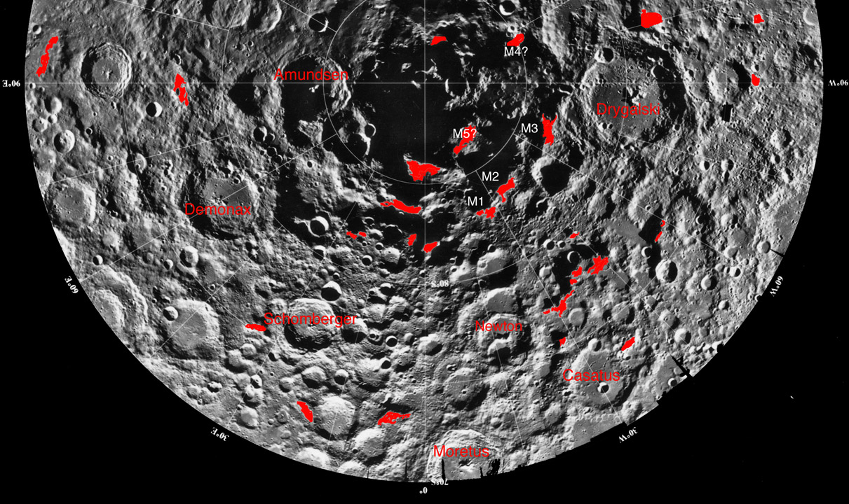
Clementine mosaic from USGS and mountains mapped by Chuck Wood; south up

Tall peaks, named the Leibnitz Mountains by Schröter, are visible near the lunar south pole, but it was difficult for the International Astronomical Union nomenclature committee to identify them and the name was erased from modern maps. But the peaks are there and the largest ones were accurately depicted in a famous map by Ewen Whitaker in 1954. I decided to use the Clementine mosaic of the south polar region, along with terrestrial radar images of the pole to look for shadow-casting peaks that are not just crater rims. I was amazed to find that there are many isolated peaks, marked in red. The white letter M and number from 1 to 5 indicate my best guess of the peaks M1 to M5 labeled on Whitaker’s chart. Some of the peaks in this area are considered to be parts of the rim of the South Pole Aitken basin - the US Geological Survey mapped a ring passing through Demonax, near Newton and near the south rim of Bailly. Some peaks shown here (90°E, 78°S, and 30°-45°W, 78°S) lie on that rim arc, but many more are interior to it, near where the rim is shown in another depiction. It seems that a new study of these polar mountains using Clementine and radar images would shed light on the South Pole-Aitken basin.

Chuck Wood

Yesterday's LPOD: A Gash and a River

Tomorrow's LPOD: Rings Around a Piddle

Related Links:


COMMENTS?

Register, and click on the Discussion tab at the top of the page.


Contributions to http://www2.lpod.org/ are licensed under a Creative Commons Attribution No-Derivative-Works Non-Commercial 3.0 License. by-nc-nd_3.0_80x15.png