Difference between revisions of "May 24, 2005"
| Line 3: | Line 3: | ||
<table width="85%" border="0" align="center" cellpadding="6" cellspacing="2"> | <table width="85%" border="0" align="center" cellpadding="6" cellspacing="2"> | ||
<tr> | <tr> | ||
| − | |||
</tr> | </tr> | ||
</table> | </table> | ||
| Line 24: | Line 23: | ||
<p align="center"><b>Grand Central Station</b></p> | <p align="center"><b>Grand Central Station</b></p> | ||
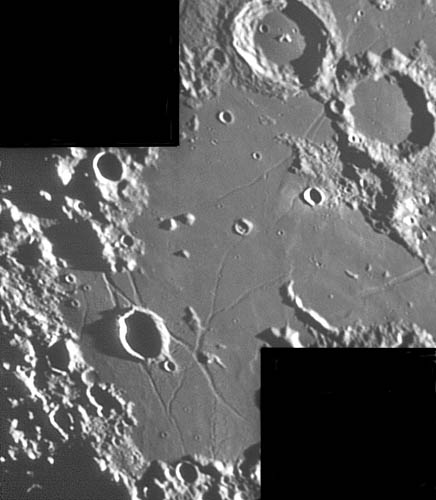
<p align="left">Palus Epidemiarum is a patch of mare occupying the southern armpit of Humorum and Nubium. This is a highly concentrated area of rilles that have little obvious relation to nearby basins. K.C.s magnificent image shows how most of these rilles intersect near Ramsden - which I liken to the old Grand Central Railway Station in New York City where all the train tracks for the eastern seaboard came together. The Clementine altimetry map demonstrates that Palus Epidemiarum slopes downward in elevation nearly 2 km from the SW to the NE. But the rilles dont appear to be related to this slope. Two of the rilles deserve attention. South of Ramsden there is a delicate feature that appears to be a crater chain (<i>cc</i> in mouseover). But this does not appear to be a secondary crater chain for there is no obvious parent crater. A strange wide rille or more likely a pair of rilles (<i>pr</i>) crosses a small patch of mare just W of Mercator. Finally, notice the high NE rim of Marth. I believe that concentric craters like Marth are impact craters that have somehow been modified to create the inner rim. But the high NE rim is difficult to explain as an impact feature - what is it?</p> | <p align="left">Palus Epidemiarum is a patch of mare occupying the southern armpit of Humorum and Nubium. This is a highly concentrated area of rilles that have little obvious relation to nearby basins. K.C.s magnificent image shows how most of these rilles intersect near Ramsden - which I liken to the old Grand Central Railway Station in New York City where all the train tracks for the eastern seaboard came together. The Clementine altimetry map demonstrates that Palus Epidemiarum slopes downward in elevation nearly 2 km from the SW to the NE. But the rilles dont appear to be related to this slope. Two of the rilles deserve attention. South of Ramsden there is a delicate feature that appears to be a crater chain (<i>cc</i> in mouseover). But this does not appear to be a secondary crater chain for there is no obvious parent crater. A strange wide rille or more likely a pair of rilles (<i>pr</i>) crosses a small patch of mare just W of Mercator. Finally, notice the high NE rim of Marth. I believe that concentric craters like Marth are impact craters that have somehow been modified to create the inner rim. But the high NE rim is difficult to explain as an impact feature - what is it?</p> | ||
| − | <blockquote><p align="right">— [mailto:tychocrater@yahoo.com Chuck Wood]</blockquote> | + | <blockquote> |
| − | <p align="left" | + | <p align="right">— [mailto:tychocrater@yahoo.com Chuck Wood]</blockquote> |
| + | <p align="left"><b>Technical Details:</b><br> | ||
19 April 2005. 10" f/6 Newtonian + 5X barlow + Philips Toucam Pro</p> | 19 April 2005. 10" f/6 Newtonian + 5X barlow + Philips Toucam Pro</p> | ||
<p><b>Related Links:</b><br> | <p><b>Related Links:</b><br> | ||
Revision as of 17:22, 17 January 2015
Grand Central Station
Image Credit: K.C. Pau
|
|
Grand Central Station Palus Epidemiarum is a patch of mare occupying the southern armpit of Humorum and Nubium. This is a highly concentrated area of rilles that have little obvious relation to nearby basins. K.C.s magnificent image shows how most of these rilles intersect near Ramsden - which I liken to the old Grand Central Railway Station in New York City where all the train tracks for the eastern seaboard came together. The Clementine altimetry map demonstrates that Palus Epidemiarum slopes downward in elevation nearly 2 km from the SW to the NE. But the rilles dont appear to be related to this slope. Two of the rilles deserve attention. South of Ramsden there is a delicate feature that appears to be a crater chain (cc in mouseover). But this does not appear to be a secondary crater chain for there is no obvious parent crater. A strange wide rille or more likely a pair of rilles (pr) crosses a small patch of mare just W of Mercator. Finally, notice the high NE rim of Marth. I believe that concentric craters like Marth are impact craters that have somehow been modified to create the inner rim. But the high NE rim is difficult to explain as an impact feature - what is it? Technical Details: Related Links: Tomorrow's LPOD: An IR Strip Across a Kipuka |
|
Author & Editor: Technical Consultant: Contact Translator: A service of: |
COMMENTS?
Register, and click on the Discussion tab at the top of the page.


