Difference between revisions of "November 18, 2007"

From LPOD
Jump to: navigation, search
(Created page with "__NOTOC__ =Re-Map-Ing the Moon= <div class="post" id="post-1525"> <div class="storycontent"> <p>MAP-Explorer-LPOD.jpg<br /> <em>image f...")
 
Line 1: Line 1:
 
__NOTOC__
 
__NOTOC__
 
=Re-Map-Ing the Moon=
 
=Re-Map-Ing the Moon=
 +
<div class="post" id="post-1525">
  
+
<div class="storycontent">
<div class="post" id="post-1525">
+
<p>[[File:MAP-Explorer-LPOD.jpg|MAP-Explorer-LPOD.jpg]]<br />
 
<div class="storycontent">
 
<p>[[File:MAP-Explorer-LPOD.jpg|MAP-Explorer-LPOD.jpg]]<br />
 
 
<em>image from [http://www.mapaplanet.org/explorer-bin/explorer.cgi?map=Moon&#038;layers=moon_lo&#038;west=-180&#038;south=-90&#038;east=180&#038;north=90&#038;center=0&#038;defaultcenter=on&#038;grid=none&#038;stretch=auto&#038;projection=SIMP&#038;advoption=NO&#038;info=NO&#038;resolution=2 Map-A-Planet Explorer]</em></p>
 
<em>image from [http://www.mapaplanet.org/explorer-bin/explorer.cgi?map=Moon&#038;layers=moon_lo&#038;west=-180&#038;south=-90&#038;east=180&#038;north=90&#038;center=0&#038;defaultcenter=on&#038;grid=none&#038;stretch=auto&#038;projection=SIMP&#038;advoption=NO&#038;info=NO&#038;resolution=2 Map-A-Planet Explorer]</em></p>
 
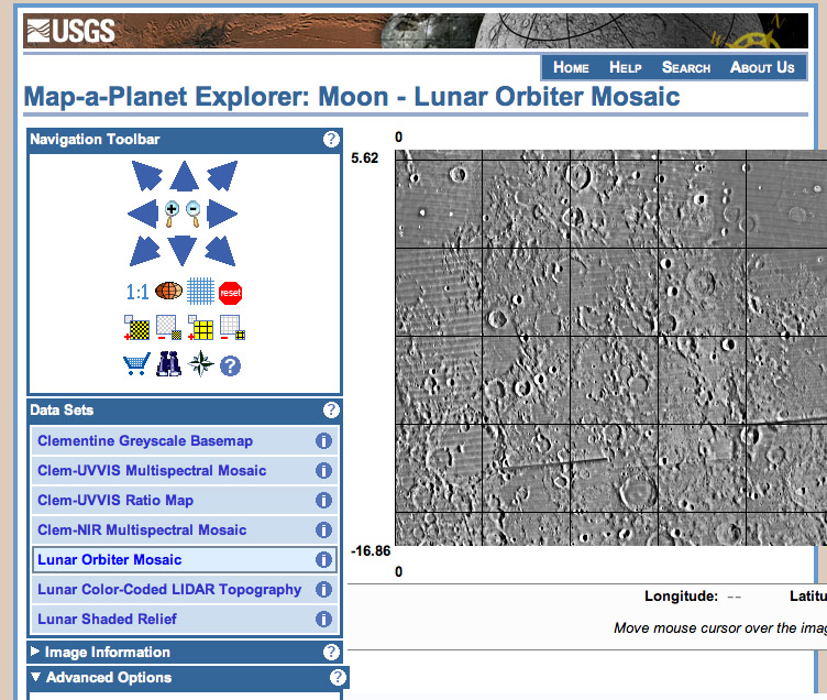
<p>I use [http://pdsmaps.wr.usgs.gov/PDS/public/explorer/html/moonpick.htm Map-A-Planet] nearly every day. This US Geologic Survey website is the easiest way to access the Clementine images, giving either black and white or false color views of anyplace on the Moon.  Now there is a new interface for MAP and more importantly, a long awaited new data set. Map-A-Planet [http://www.mapaplanet.org/explorer/moon.html Explorer] now includes the USGS Lunar Orbiter IV mosaic. The Survey has mosaicked all the separate LO image strips into a huge nearside image, although for some reason, here it only covers 45° N to S; Orbiter&#8217;s poor imagery also limits its eastern coverage to 45°E. The LO mosaic unfortunately is rather bland (low contrast) until magnification reaches 1 km/pixel. But all the strips have been tied to the lunar control network so that you can read off the coordinates of any feature of interest. Of course, greedy users will wish for a tool that allows measurements of distances between points, or even determination of depths from shadow measurements; Jim Mosher&#8217;s [http://inet.uni2.dk/~d120588/henrik/jim_ltvt.html LTVT] permits this, but not as an online tool. The new MAP interface removes one of the unpleasant aspects of the &#8220;classic&#8221; MAP - now you can incrementally zoom from a wide view to a closeup one, which makes it much easier to make sure you get where you want to be. MAP Explorer has other features of value, and it works not just for the Moon but for all the [http://www.mapaplanet.org/ other] moons and planets with global datasets. This is a nice model for how image data from SMART-1, Kaguya and other new lunar probes can be made available to users everywhere. Let&#8217;s hope.</p>
 
<p>I use [http://pdsmaps.wr.usgs.gov/PDS/public/explorer/html/moonpick.htm Map-A-Planet] nearly every day. This US Geologic Survey website is the easiest way to access the Clementine images, giving either black and white or false color views of anyplace on the Moon.  Now there is a new interface for MAP and more importantly, a long awaited new data set. Map-A-Planet [http://www.mapaplanet.org/explorer/moon.html Explorer] now includes the USGS Lunar Orbiter IV mosaic. The Survey has mosaicked all the separate LO image strips into a huge nearside image, although for some reason, here it only covers 45° N to S; Orbiter&#8217;s poor imagery also limits its eastern coverage to 45°E. The LO mosaic unfortunately is rather bland (low contrast) until magnification reaches 1 km/pixel. But all the strips have been tied to the lunar control network so that you can read off the coordinates of any feature of interest. Of course, greedy users will wish for a tool that allows measurements of distances between points, or even determination of depths from shadow measurements; Jim Mosher&#8217;s [http://inet.uni2.dk/~d120588/henrik/jim_ltvt.html LTVT] permits this, but not as an online tool. The new MAP interface removes one of the unpleasant aspects of the &#8220;classic&#8221; MAP - now you can incrementally zoom from a wide view to a closeup one, which makes it much easier to make sure you get where you want to be. MAP Explorer has other features of value, and it works not just for the Moon but for all the [http://www.mapaplanet.org/ other] moons and planets with global datasets. This is a nice model for how image data from SMART-1, Kaguya and other new lunar probes can be made available to users everywhere. Let&#8217;s hope.</p>
 
<p>[mailto:tychocrater@yahoo.com Chuck Wood]</p>
 
<p>[mailto:tychocrater@yahoo.com Chuck Wood]</p>
 
<p><em>Now you can support LPOD when you buy any book from Amazon thru [[LPOD]]</em></p>
 
<p><em>Now you can support LPOD when you buy any book from Amazon thru [[LPOD]]</em></p>
</div>
+
</div>


----
 
----
 
===COMMENTS?===  
 
===COMMENTS?===  
 
Click on this icon [[image:PostIcon.jpg]] at the upper right to post a comment.
 
Click on this icon [[image:PostIcon.jpg]] at the upper right to post a comment.

Revision as of 18:00, 4 January 2015

Re-Map-Ing the Moon

MAP-Explorer-LPOD.jpg
image from Map-A-Planet Explorer

I use Map-A-Planet nearly every day. This US Geologic Survey website is the easiest way to access the Clementine images, giving either black and white or false color views of anyplace on the Moon. Now there is a new interface for MAP and more importantly, a long awaited new data set. Map-A-Planet Explorer now includes the USGS Lunar Orbiter IV mosaic. The Survey has mosaicked all the separate LO image strips into a huge nearside image, although for some reason, here it only covers 45° N to S; Orbiter’s poor imagery also limits its eastern coverage to 45°E. The LO mosaic unfortunately is rather bland (low contrast) until magnification reaches 1 km/pixel. But all the strips have been tied to the lunar control network so that you can read off the coordinates of any feature of interest. Of course, greedy users will wish for a tool that allows measurements of distances between points, or even determination of depths from shadow measurements; Jim Mosher’s LTVT permits this, but not as an online tool. The new MAP interface removes one of the unpleasant aspects of the “classic” MAP - now you can incrementally zoom from a wide view to a closeup one, which makes it much easier to make sure you get where you want to be. MAP Explorer has other features of value, and it works not just for the Moon but for all the other moons and planets with global datasets. This is a nice model for how image data from SMART-1, Kaguya and other new lunar probes can be made available to users everywhere. Let’s hope.

Chuck Wood

Now you can support LPOD when you buy any book from Amazon thru LPOD


COMMENTS?

Click on this icon File:PostIcon.jpg at the upper right to post a comment.