Difference between revisions of "June 20, 2007"

From LPOD
Jump to: navigation, search
(Created page with "__NOTOC__ =A Newer New Map= <div class="post" id="post-1195"> <div class="storycontent"> <p>LAC90-LPOD.jpg<br /> <em>map modified from[http://...")
 
Line 1: Line 1:
 
__NOTOC__
 
__NOTOC__
 
=A Newer New Map=
 
=A Newer New Map=
 +
<div class="post" id="post-1195">
  
+
<div class="storycontent">
<div class="post" id="post-1195">
+
<p>[[File:LAC90-LPOD.jpg|LAC90-LPOD.jpg]]<br />
 
<div class="storycontent">
 
<p>[[File:LAC90-LPOD.jpg|LAC90-LPOD.jpg]]<br />
 
 
<em>map modified from[http://planetarynames.wr.usgs.gov/dAtlas.html  USGS Digital Atlas of the Moon] by Chuck Wood</em> </p>
 
<em>map modified from[http://planetarynames.wr.usgs.gov/dAtlas.html  USGS Digital Atlas of the Moon] by Chuck Wood</em> </p>
 
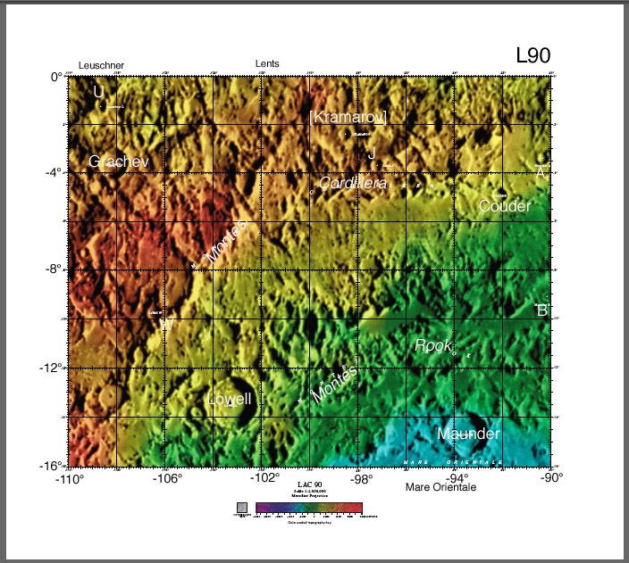
<p>Lunar nomenclature has been a mess, on and off, for 350 years. Since the early 1900s there have been multiple efforts to collate and standardize nomenclature. But there are still areas of confusion in limb regions, poor nomenclature decisions in the 1970s caused chaos, and many farside names were given based on limited and poor images. Now the USGS is making a herculean effort to create a new standardized (and as correct as possible) IAU nomenclatural atlas of the Moon in a digital format that can be updated as new names are given. So far, much of the farside of the Moon has been mapped and is now online at the US Geological Survey Astrogeology [http://planetarynames.wr.usgs.gov/dAtlas.html website]. Here is one of the charts, showing the northwest area of the Orientale Basin. Unfortunately, the type on the original map is so small that it can only be read when the map is enlarged to a 30&#8243; by 27&#8243; size. That means that the entire chart is not legible either on a computer screen (of normal size) or when printed out on a 8.5&#8243; by 11&#8243; piece of paper. I have shown above how larger type sizes could make the charts legible at normal screen and paper sizes. I don&#8217;t have proper fonts to make type visible against dark and light backgrounds but this example demonstrates that a legible map could be made. The use of the USGS shaded relief map (with topo color overlay) also creates problems because it does not accurately depict the lunar surface and especially the visibility of different craters. And the color makes black &#038; white prints hard to read. But there is no good and homogeneous base map or image map of the Moon. Finally, there are two new names on this map, compared to the same area mapped in the <em>Clementine Atlas of the Moon</em> by Bussey and Spudis. The crater Maunder Z is now Couder, and Lens K is now changed to Kramarov (and Lens is correctly spelled: Lentz). Neither of these craters is large enough to deserve a name (rather than a letter) and they violate good nomenclature practice. Kramarov is placed  between Lentz and Lentz J, and Couder is between Maunder and Maunder A. These problems would have been eliminated if the name Couder had been given to Maunder A, and if Kramarov was given to Lentz K. Although it is slightly outdated (and has a number of spelling [http://www.lpod.org/cwm/DataStuff/clem-corrections.htm errors]) the <em>Clementine Atlas</em> is still the most legible atlas to consult for nomenclature. And of course, the Virtual Moon Atlas and LTVT provide additional online alternatives. </p>
 
<p>Lunar nomenclature has been a mess, on and off, for 350 years. Since the early 1900s there have been multiple efforts to collate and standardize nomenclature. But there are still areas of confusion in limb regions, poor nomenclature decisions in the 1970s caused chaos, and many farside names were given based on limited and poor images. Now the USGS is making a herculean effort to create a new standardized (and as correct as possible) IAU nomenclatural atlas of the Moon in a digital format that can be updated as new names are given. So far, much of the farside of the Moon has been mapped and is now online at the US Geological Survey Astrogeology [http://planetarynames.wr.usgs.gov/dAtlas.html website]. Here is one of the charts, showing the northwest area of the Orientale Basin. Unfortunately, the type on the original map is so small that it can only be read when the map is enlarged to a 30&#8243; by 27&#8243; size. That means that the entire chart is not legible either on a computer screen (of normal size) or when printed out on a 8.5&#8243; by 11&#8243; piece of paper. I have shown above how larger type sizes could make the charts legible at normal screen and paper sizes. I don&#8217;t have proper fonts to make type visible against dark and light backgrounds but this example demonstrates that a legible map could be made. The use of the USGS shaded relief map (with topo color overlay) also creates problems because it does not accurately depict the lunar surface and especially the visibility of different craters. And the color makes black &#038; white prints hard to read. But there is no good and homogeneous base map or image map of the Moon. Finally, there are two new names on this map, compared to the same area mapped in the <em>Clementine Atlas of the Moon</em> by Bussey and Spudis. The crater Maunder Z is now Couder, and Lens K is now changed to Kramarov (and Lens is correctly spelled: Lentz). Neither of these craters is large enough to deserve a name (rather than a letter) and they violate good nomenclature practice. Kramarov is placed  between Lentz and Lentz J, and Couder is between Maunder and Maunder A. These problems would have been eliminated if the name Couder had been given to Maunder A, and if Kramarov was given to Lentz K. Although it is slightly outdated (and has a number of spelling [http://www.lpod.org/cwm/DataStuff/clem-corrections.htm errors]) the <em>Clementine Atlas</em> is still the most legible atlas to consult for nomenclature. And of course, the Virtual Moon Atlas and LTVT provide additional online alternatives. </p>
Line 14: Line 12:
 
<p align="center"><strong><br />
 
<p align="center"><strong><br />
 
<em>You can now buy any book from Amazon thru [[LPOD]]</em></strong></p>
 
<em>You can now buy any book from Amazon thru [[LPOD]]</em></strong></p>
</div>
+
</div>


----
 
----
 
===COMMENTS?===  
 
===COMMENTS?===  
 
Click on this icon [[image:PostIcon.jpg]] at the upper right to post a comment.
 
Click on this icon [[image:PostIcon.jpg]] at the upper right to post a comment.

Revision as of 17:54, 4 January 2015

A Newer New Map

LAC90-LPOD.jpg
map modified fromUSGS Digital Atlas of the Moon by Chuck Wood

Lunar nomenclature has been a mess, on and off, for 350 years. Since the early 1900s there have been multiple efforts to collate and standardize nomenclature. But there are still areas of confusion in limb regions, poor nomenclature decisions in the 1970s caused chaos, and many farside names were given based on limited and poor images. Now the USGS is making a herculean effort to create a new standardized (and as correct as possible) IAU nomenclatural atlas of the Moon in a digital format that can be updated as new names are given. So far, much of the farside of the Moon has been mapped and is now online at the US Geological Survey Astrogeology website. Here is one of the charts, showing the northwest area of the Orientale Basin. Unfortunately, the type on the original map is so small that it can only be read when the map is enlarged to a 30″ by 27″ size. That means that the entire chart is not legible either on a computer screen (of normal size) or when printed out on a 8.5″ by 11″ piece of paper. I have shown above how larger type sizes could make the charts legible at normal screen and paper sizes. I don’t have proper fonts to make type visible against dark and light backgrounds but this example demonstrates that a legible map could be made. The use of the USGS shaded relief map (with topo color overlay) also creates problems because it does not accurately depict the lunar surface and especially the visibility of different craters. And the color makes black & white prints hard to read. But there is no good and homogeneous base map or image map of the Moon. Finally, there are two new names on this map, compared to the same area mapped in the Clementine Atlas of the Moon by Bussey and Spudis. The crater Maunder Z is now Couder, and Lens K is now changed to Kramarov (and Lens is correctly spelled: Lentz). Neither of these craters is large enough to deserve a name (rather than a letter) and they violate good nomenclature practice. Kramarov is placed between Lentz and Lentz J, and Couder is between Maunder and Maunder A. These problems would have been eliminated if the name Couder had been given to Maunder A, and if Kramarov was given to Lentz K. Although it is slightly outdated (and has a number of spelling errors) the Clementine Atlas is still the most legible atlas to consult for nomenclature. And of course, the Virtual Moon Atlas and LTVT provide additional online alternatives.

Chuck Wood

Technical Details:
The tiny white dots on the map above are the original letters on the chart. Following nomenclature practice since Beer and Madler, the letter of a designated crater is placed in line between it and its named crater.


You can now buy any book from Amazon thru LPOD


COMMENTS?

Click on this icon File:PostIcon.jpg at the upper right to post a comment.