Difference between revisions of "April 10, 2011"
| Line 3: | Line 3: | ||
<!-- ws:start:WikiTextHeadingRule:0:<h1> --> | <!-- ws:start:WikiTextHeadingRule:0:<h1> --> | ||
<!-- ws:start:WikiTextLocalImageRule:6:<img src="/file/view/LPOD-Apr10-11.jpg/218768680/LPOD-Apr10-11.jpg" alt="" title="" /> -->[[File:LPOD-Apr10-11.jpg|LPOD-Apr10-11.jpg]]<!-- ws:end:WikiTextLocalImageRule:6 --><br /> | <!-- ws:start:WikiTextLocalImageRule:6:<img src="/file/view/LPOD-Apr10-11.jpg/218768680/LPOD-Apr10-11.jpg" alt="" title="" /> -->[[File:LPOD-Apr10-11.jpg|LPOD-Apr10-11.jpg]]<!-- ws:end:WikiTextLocalImageRule:6 --><br /> | ||
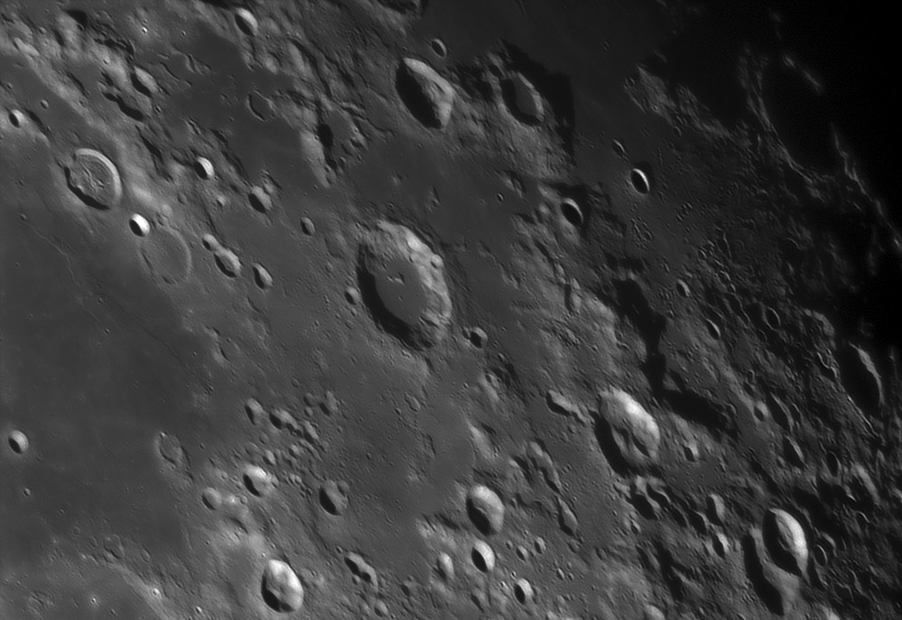
| − | <em>image by [mailto:bob_p@earthlink.net | + | <em>image by [mailto:bob_p@earthlink.net Bob Pilz]</em><br /> |
<br /> | <br /> | ||
| − | Do you see three basin rings here? Look closer. And step back for a more synoptic [http://www.lpod.org/?m=20061210 | + | Do you see three basin rings here? Look closer. And step back for a more synoptic [http://www.lpod.org/?m=20061210 view].Like most basins the expression of Nectaris' different rings varies around the basin. The magnificent 860 km diameter Altai Scarp main ring appears on this east side of Nectaris as a range of low mountains seen between [http://the-moon.wikispaces.com/file/detail/Rukl_59_satellites.jpg Borda and flat-floored Biot B]. The next smaller ring - that passes through Catharina on the west side - is barely visible as scattered hills north and south of Santbach. This part of the innermost mountainous ring actually has a name - the Pyrenees Mountains at upper left - and bounds Mare Nectaris, There is a fourth basin ring, but it is marked by mare ridges rather than mountains. It is about 240 km wide, with a piece being just visible in the mare near upper left and another piece [http://the-moon.wikispaces.com/LPOD+Feb+4%2C+2008 stretching] from Theophilus to Fracastorius. In fact, if this ridge ring is the boundary of an inner area of collapse to a lower level (as at Crisium) it might explain what happened to the missing northern arc of Fracastorius' rim.<br /> |
<br /> | <br /> | ||
| − | <em>[mailto:tychocrater@yahoo.com | + | <em>[mailto:tychocrater@yahoo.com Chuck Wood]</em><br /> |
<br /> | <br /> | ||
<strong>Technical Details</strong><br /> | <strong>Technical Details</strong><br /> | ||
Revision as of 16:33, 11 January 2015
Sweet Rings

image by Bob Pilz
Do you see three basin rings here? Look closer. And step back for a more synoptic view.Like most basins the expression of Nectaris' different rings varies around the basin. The magnificent 860 km diameter Altai Scarp main ring appears on this east side of Nectaris as a range of low mountains seen between Borda and flat-floored Biot B. The next smaller ring - that passes through Catharina on the west side - is barely visible as scattered hills north and south of Santbach. This part of the innermost mountainous ring actually has a name - the Pyrenees Mountains at upper left - and bounds Mare Nectaris, There is a fourth basin ring, but it is marked by mare ridges rather than mountains. It is about 240 km wide, with a piece being just visible in the mare near upper left and another piece stretching from Theophilus to Fracastorius. In fact, if this ridge ring is the boundary of an inner area of collapse to a lower level (as at Crisium) it might explain what happened to the missing northern arc of Fracastorius' rim.
Chuck Wood
Technical Details
UD: 2008/08/19, UT: ~07:45. 200mm f/6 Newtonian, Televue 3X Barlow, DMK 31 camera, Green Filter; 15 fps, Exposure 1/38sec, 400/9000 frames. Reprocessed by Registax V6, PS CS4, FocusMagic. Taken from Lat: 35 degrees 36 minutes N, Long: 82 degrees 33 minutes W, Elev: ~850m
Related Links
Rükl plate 59


