Difference between revisions of "November 15, 2009"
| Line 3: | Line 3: | ||
<!-- ws:start:WikiTextHeadingRule:1:<h1> --> | <!-- ws:start:WikiTextHeadingRule:1:<h1> --> | ||
<!-- ws:start:WikiTextLocalImageRule:16:<img src="/file/view/LPOD-Nov15-09.jpg/102686843/LPOD-Nov15-09.jpg" alt="" title="" /> -->[[File:LPOD-Nov15-09.jpg|LPOD-Nov15-09.jpg]]<!-- ws:end:WikiTextLocalImageRule:16 --><br /> | <!-- ws:start:WikiTextLocalImageRule:16:<img src="/file/view/LPOD-Nov15-09.jpg/102686843/LPOD-Nov15-09.jpg" alt="" title="" /> -->[[File:LPOD-Nov15-09.jpg|LPOD-Nov15-09.jpg]]<!-- ws:end:WikiTextLocalImageRule:16 --><br /> | ||
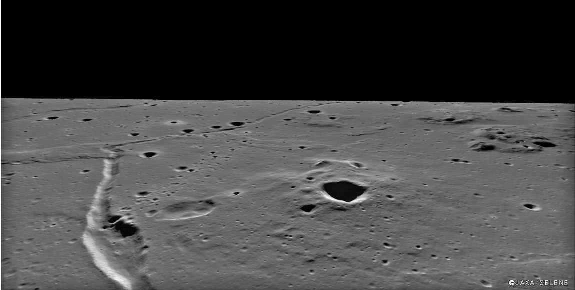
| − | <em>image from [http://wms.selene.jaxa.jp/selene_viewer/jpn/observation_mission/tc/tc_046.html | + | <em>image from [http://wms.selene.jaxa.jp/selene_viewer/jpn/observation_mission/tc/tc_046.html JAXA-Kaguya Image Gallery]</em><br /> |
<br /> | <br /> | ||
| − | Looking like a superb Chesley Bonestell painting, this oblique view of [http://www.lpod.org/coppermine/albums/userpics/Marius_Hills_IV-157-H2.jpg | + | Looking like a superb Chesley Bonestell painting, this oblique view of [http://www.lpod.org/coppermine/albums/userpics/Marius_Hills_IV-157-H2.jpg Marius Hills rilles] is a perspective view constructed from real data. Using Terrain Camera stereo images, Kaguya scientists created a digital terrain map, and then an image was draped over it, allowing computer views from any angle. At left front is a <em>Cobra Head-like</em> depression that was the source vent for a barely sinuous rille that deposited the flat-lying lavas that surround the older rough domes such as the one at front right. Between the rille vent and dome is an odd gentle-sloped depression with a central hill, conceivably an impact crater overflown by lavas, but more likely a volcanic collapse crater. The shadow-filled crater near the summit of the dome appears to be an impact crater, as are most of the shadow-filled craters in the scene. At left center the rille bends sharply where it intersects a mare ridge. From this view it is possible that the ridge formed after the rille, but high resolution Orbiter V [http://www.lpi.usra.edu/resources/lunarorbiter/frame/?5214 images] suggests that the rille cuts the ridge. But it is hard to understand how a rille - which always flows downhill - could cut through the higher ridge, so I suppose that the ridge has uplifted the rille. I almost believe that, but I bet that the ridge was there first and it somehow diverted the flowing lava and its rille. What do you think?<br /> |
<br /> | <br /> | ||
| − | <em>[mailto:tychocrater@yahoo.com | + | <em>[mailto:tychocrater@yahoo.com Chuck Wood]</em><br /> |
<br /> | <br /> | ||
<strong>Related Links</strong><br /> | <strong>Related Links</strong><br /> | ||
Rükl plate [http://the-moon.wikispaces.com/R%C3%BCkl+29 29]<br /> | Rükl plate [http://the-moon.wikispaces.com/R%C3%BCkl+29 29]<br /> | ||
| − | One of the [http://wms.selene.jaxa.jp/selene_viewer/jpn/observation_mission/tc/046/tc_046_4.jpg | + | One of the [http://wms.selene.jaxa.jp/selene_viewer/jpn/observation_mission/tc/046/tc_046_4.jpg vertical view] Kaguya images that the stereo map was made from.<br /> |
<br /> | <br /> | ||
<hr /> | <hr /> | ||
| − | <div>You can support LPOD when you buy any book from Amazon thru [http://www.lpod.org/?page_id=591 | + | <div>You can support LPOD when you buy any book from Amazon thru [http://www.lpod.org/?page_id=591 LPOD!]<br /> |
</div> | </div> | ||
---- | ---- | ||
===COMMENTS?=== | ===COMMENTS?=== | ||
| − | + | Register, and click on the <b>Discussion</b> tab at the top of the page. | |
Revision as of 18:05, 17 January 2015
Hills, Troughs And a Collapse

image from JAXA-Kaguya Image Gallery
Looking like a superb Chesley Bonestell painting, this oblique view of Marius Hills rilles is a perspective view constructed from real data. Using Terrain Camera stereo images, Kaguya scientists created a digital terrain map, and then an image was draped over it, allowing computer views from any angle. At left front is a Cobra Head-like depression that was the source vent for a barely sinuous rille that deposited the flat-lying lavas that surround the older rough domes such as the one at front right. Between the rille vent and dome is an odd gentle-sloped depression with a central hill, conceivably an impact crater overflown by lavas, but more likely a volcanic collapse crater. The shadow-filled crater near the summit of the dome appears to be an impact crater, as are most of the shadow-filled craters in the scene. At left center the rille bends sharply where it intersects a mare ridge. From this view it is possible that the ridge formed after the rille, but high resolution Orbiter V images suggests that the rille cuts the ridge. But it is hard to understand how a rille - which always flows downhill - could cut through the higher ridge, so I suppose that the ridge has uplifted the rille. I almost believe that, but I bet that the ridge was there first and it somehow diverted the flowing lava and its rille. What do you think?
Chuck Wood
Related Links
Rükl plate 29
One of the vertical view Kaguya images that the stereo map was made from.
COMMENTS?
Register, and click on the Discussion tab at the top of the page.


